

Silas Lang
-
Posts
696 -
Joined
-
Last visited
Content Type
Profiles
Blogs
Forums
American Weather
Media Demo
Store
Gallery
Posts posted by Silas Lang
-
-
1 hour ago, Holston_River_Rambler said:
So de we think much of this will hold together?
Looks like High Knob is at least going to get a couple of inches tonight.
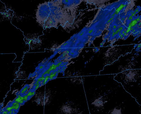
HRRR tries to kill it off, but I don't think that will happen. Now it may not make it to teh ground, but I think the radar returns will hold together:
Notice (Tri Cities folks) that there is also some weird 181 or 26 or whatever it is now band that shows up. It literally looks like it starts as some lift over the Eastman Bubble and then follows someone to JC. I'll be asleep, but will be interested to see if that verifies on radar overnight. maybe it is the ultra rare Bays Mountain point leeside low?
JiC index may be in its COD, but it is still in the good phases 8/1 and we also we have the all important No One Cares Anymore (NOCA) index going for this to overperform tonight. Level of public and even weenie interest in any given event are like the SOI. We've dropped to -31.23 for this event.
I appreciate this post. And LOL at the last part. On the NOCA, yeah, not feeling too interested in winter for the foreseeable future due how things have been trending. I do like that about this forum; not a whole lot of cliff diving. We all just tend to quietly walk away.
Anyway could feel the front blowing in today as it got cooler. Sitting at 40 here now.
-
 1
1
-
-
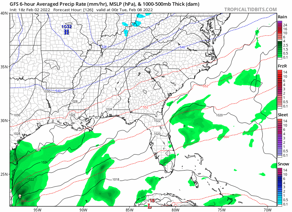
Looks like we are trending towards mostly cloudy in regards to the weekend system. Snow chances went poof on most models today.
-
 3
3
-
-
4 minutes ago, Holston_River_Rambler said:
I don't know that we had a storm thread for it (maybe I missed it) but the obs for this start on page 12:
I will take that analogue in a heartbeat. Looks like a wide spread 2 to 4 inch event in East TN according to the thread.
-
1
-
-
4 minutes ago, Carvers Gap said:
This is a super similar set-up to how middle and west TN have scored...just displace the primary east of the Apps(instead of the eastern valley and secondary to the coast(instead of western NC). The really headache is accounting for two mountain ranges(the Plateau and Apps) being under the western precip shield instead of just the Plateau. The 12z set-up could be a combo of orographic lift and downsloping, one replacing the other depending on location. Fun times. LOL.
Ah okay, that makes it easier to visualize as I feel like we have seen that set-up dozens of times the past few years here in the east. lol
Do you know of any historical events that gave us snow here in the east similar to this storm?
-
Good to at least see some snow on the CMC.
15 minutes ago, Carvers Gap said:Super complex setup which makes me wary. Basically, the GFS pops a lee side low(western NC) as the front passes. That happens often(just fain). The front running energy along the coast interacts, and the lee side energy transfers to the coast. This is like a Miller B, but east of the mountains. Those setups do occasionally happen - ceiling is high and bust potential is massive.
Thanks for the clarification. It almost looks like the CMC wants to make that low the main low and doesn't transfer until well north. I can see how this set up throws off the models. They don't know where to place the low which creates a high bust scenario. Plus you factor in all this energy flying around...yikes.
I will say, I am feeling more confident we will see snow Sunday. How much remains to be seen.
-
1
-
-
8 minutes ago, Carvers Gap said:
The GFS was flirting (and has been) with an inland runner. It could still settle on the coastal which is likely just a weak clipper, but if it goes to the inland runner solution...that would be optimal. The RGEM is likely amped at this range, but that look would be a forum-wide snow if extrapolated...and totals bias corrected to zero for Kingsport and Chattanooga of course.
Just curious, could that other LP you mentioned earlier on the other side of the mountains be a faint signal for an inland runner?
Don't want to get greedy, but if we are getting close to a big dog event...I would like it. We do have the fact that John is going to be in Chattanooga to increase our luck

-
3
-
 2
2
-
-
12z top and 6z bottom
.thumb.png.cb1aff5a8e9a9f915e807d757d5da067.png)
-
6
-
-
Just now, Carvers Gap said:
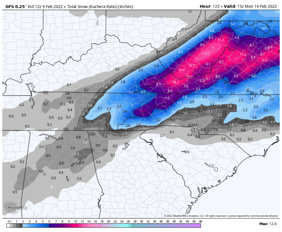
The 12z GFS is a great run. 9" for JC and half a foot for Sullivan. The 12z RGEM(at range and noted) looks like it was ready to rock with a vigorous system. Of note, double barrel systems are trick as @#$ to forecast.
Yeah the RGEM was looking to form a low in the gulf as well. Curious to see what the Euro does.
-
1
-
-
12z GFS looks pretty similar to 6z.
-
2
-
-
13 minutes ago, Carvers Gap said:
It may be that we see a double barrel low with one in the coast and one on the lee of the Apps...reference LC.
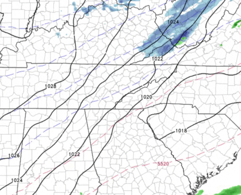
Would we see that looking at the surface? At hour 99 on the GFS you can see some lower pressure climbing up into nw south Carolina for a few hours before the low pops out in the Atlantic. That feature was not present on the 0z.
-
27 minutes ago, Carvers Gap said:
I know I sound like a broken record but, it is not uncommon for systems to gain strength(on modeling) during February. Also, I still don't believe modeling has a good handle on this system Sunday, even at this range. I don't think it will be anything huge, but it is very possible snow will be in the air along(just north and south) of the northern border of TN. And broken record alert again...low probability(increasing) along with a high upside.
Yeah it looks like that snow is mostly coming from the northern energy and the front. The low pressure is still actually pretty far east.
The good news is temps look pretty good and it occurs at night for middle and eastern areas. Even if it stays a lighter event, there shouldn't be a whole lot of wasted precipitation which is always a win.
-
1
-
-
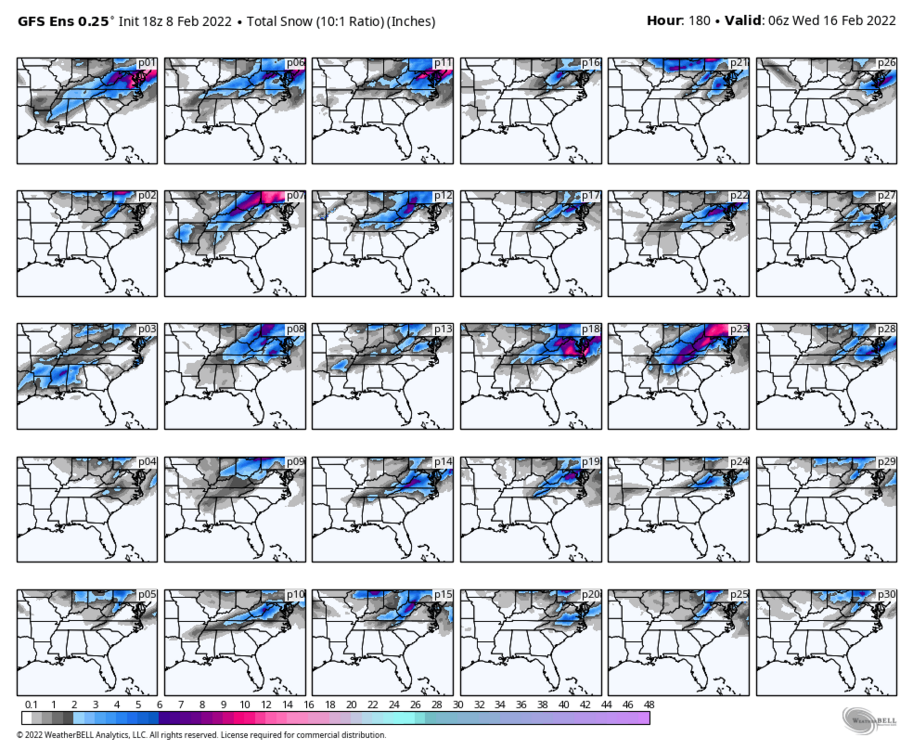
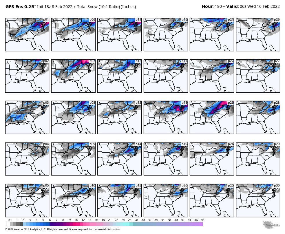
The 18z Euro ensembles are bit more all or nothing. 8 or 9 moderate hits with a lot of blanks and several flizzard and dusting level events. No real big dogs.
-
2
-
-
Honestly, not too bad for snow next weekend. Not too many total blanks, a lot of lighter events, a few moderate, and one big dog. I don't know about a big dog, but I think odds of seeing some snow on Sunday are pretty good, especially north of 40. Just the fact that for some reason climo likes this time of year (Valentine's day) makes me feel a bit more bullish on the odds.
-
2
-
-
50 minutes ago, Holston_River_Rambler said:
The basic idea of the 0z GFS is still there at 6z, just a tad further SE.
Yup. I think that is the first time it has appeared two runs in a row. Hopefully it continues with the 12z today. Would like to see it on the Euro as well.
-
1
-
-
2 minutes ago, John1122 said:
Those last two runs of the Euro/GFS are what winter storm dreams are made of across the Valley region.
Indeed. Temps are below freezing during the event and stay that way for days afterwards. Lows in the single digits and teens at night. Perfect winter storm for the area.
-
5
-
-
Nuts to see something so similar on the GFS and Euro. Seems they have been at odds frequently this year. Let's see if we can't get some ensemble support as well.
-
1
-
-
-
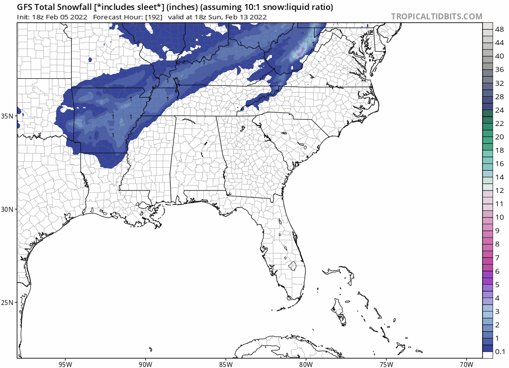
18z GFS has the storm next weekend as well. Pops a weak low into central AL to north GA and keeps it just to the other side of the mountains. Snow maps not too different from Euro.
-
Definitely some black ice in town tonight. My deck is slick at 30 degrees and the roads look wet.
-
3
-
-
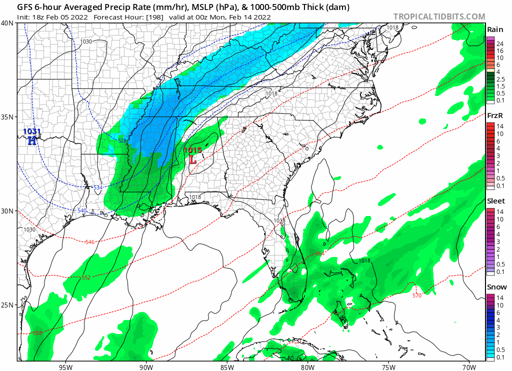
Yeah the Monday/Tuesday window has been trending NW. Good to see the Euro moving towards it as well as the GFS. Saw this gif posted in the southeast thread showing the trend on the GFS:
-
2
-
-
7 minutes ago, John1122 said:
There was a big winter storm Valentines Day 2016. It was ice/sleet in lower elevations and a front end snow thump along the Plateau and NE areas.
Thanks, I stand corrected. I don't know how I missed it looking through the threads. Well climo does seem to favor that period for some reason. Hope we get some action this go round.
-
1
-
-
6 minutes ago, Vol Man said:
I believe it was Valentine's Day in 1987 that Kingsport got about a 7-8 inch snow. Started late afternoon, if I remember correctly. We live in Colonial Heights at the time, and had quite a time getting home from work in a Honda Prelude.
In the other thread it was brought up that TYS and TRI had their best January snowfall since 2014 and 2016. I looked up the following Februarys and it looks like 2014 had the storm that clobbered the valley around Valentine's day in 2014. Nothing big in 2016. Anyway, hopefully this year we can get lucky around that time once again.
-
1
-
-
With the highest totals since 2014 for TYS and 2016 for TRI, what was the February like in the valley for those years? I seem to remember 2014 having a couple of decent snows, but my memory is foggy.
-
16 hours ago, John1122 said:
From MRX for January.
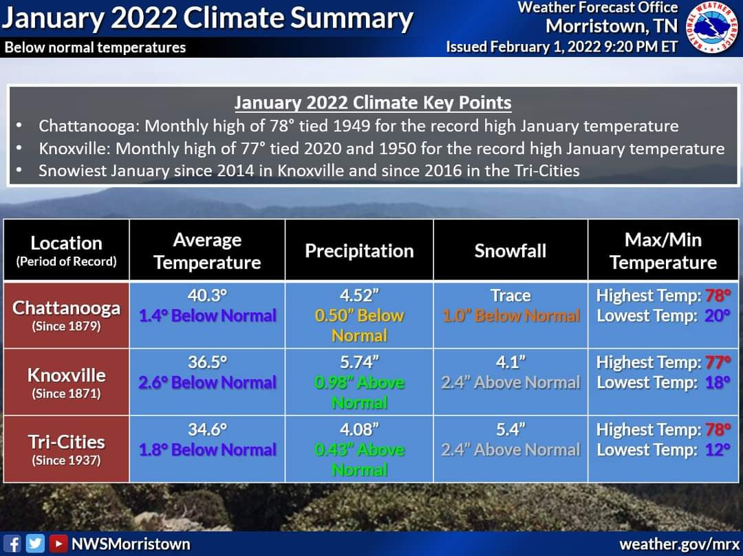
Nashville had 9.5 per OHX, Jamestown 13, Allardt 20.1. Couldn't find Crossville data. I ended up with 19.8 inches in January. Sad that 4 inches is the most snow in Knoxville in January since 2014. Also wild to set all time monthly record highs, not get remotely close to any record lows, but still finish BN for the month temp wise.
Pretty odd for Knox to have that much considering they measured two storms at .20 inches. I have measured 4.5, but it was a bit more evenly distributed between systems.
-
1
-

.png.3855427ecdf0f0b692c6a0d224b23d32.png)
Winter 2021/2022 February Thread
in Tennessee Valley
Posted
Same. Mountains and some upper Plateau areas can score later, but it typically ends up as a cold rain here. Not really interested in that. If it is going to rain, then I at least want it warmer.