

Silas Lang
-
Posts
696 -
Joined
-
Last visited
Content Type
Profiles
Blogs
Forums
American Weather
Media Demo
Store
Gallery
Posts posted by Silas Lang
-
-
I like where we are at with the pending NW trend. Is there any reason this would stay suppressed?
-
 1
1
-
-
1 minute ago, Blue Ridge said:
Nice little reverse jinx. Good looking out, MRX!
I do find it peculiar to drop the WWA in areas that have already seen snow. Criteria is so low, I would imagine leaving in place would be beneficial to cover potential road hazards at minimum.
Yeah roads are going to be awful with the temps. Surprised they cancelled the advisory due to poor conditions regardless of accumulation.
-
2 minutes ago, bearman said:
And as soon as they did my road turned white in west Knoxville.
Maybe it was jinxing us?! Roads are now white here. No more sleet.
Before it starting snowing hard again there was a lot of wind and a few minute burst of heavy sleet. It almost looked like rock salt falling out of the sky. Now it is dumping snow. Down to 31 as well.
-
2
-
-
Perfect time to lift the advisory. Ripping here again. Definitely a lot of sleet. But roads will be a mess.
-
1
-
-
I still think there is a chance for some action. Even the HRRR which has shown the NW trend shows the system reorienting.
-
 1
1
-
-
2 minutes ago, Holston_River_Rambler said:
North wind really starting to crank up here.
Yeah, have a had a north wind since the big snow burst an hour or so ago. Tiny flakes been falling steady here since then. Not really adding up a whole lot, but still have a solid dusting. Just hit 32 a few minutes ago after hanging at 33 for a while. Hopeful I can score at least 2 or 3 out of this event.
In Knox, a few miles north of 40 and downtown.
-
1
-
-
Temp fell 2 degrees. Down to 33 here. Got a thick dusting at the moment.
-
Just started ripping here. Beautiful. All snow.
-
3
-
-
There is definitely a warm layer. When it slows down there is more mixed frozen precipitation. Making my yard nice and crunchy. Roads going to be bad later. However, no rain like forecasted.
-
1 minute ago, PowellVolz said:
I’m right at the bottom of the MCD line

.I am just outside of it myself. Regardless starting to feel better about Knox based on the obs here.
-
1
-
-
Starting to pick up a little. All snow now! Dime flakes and starting to stick on deck and grass. Went from 36 to 35 degrees.
-
2
-
-
Getting some light snow, graupel, and sleet here north of downtown. 36 degrees.
-
1
-
-
1 hour ago, Carvers Gap said:
Well, the 12z GFS isn't going to back down not matter what! Can't decide whether to chuckle or not.
I just looked at it. I am rooting for it here! lol If nothing else, it has been consistent for sure.
Currently 35 here and cloudy.
-
Knox County has a pretty brutal cutoff on the HRRR and latest NAM. The city itself is almost the dividing line. A scenario where the northern part of the county could get 2 to 4 inches and the southern part a dusting. However, the GFS and RGEM are generous to all in the county (and the eastern valley). Really curious to see what plays out as it officially nowcasting time. Rooting for the latter for us all!

-
1
-
-
5 hours ago, John1122 said:
The QBO has progressed deeply into the negative, around -24 to -25. Our last progression this deep into the negative in January/February was 2015 when we saw brutal cold and snow/ice in February.
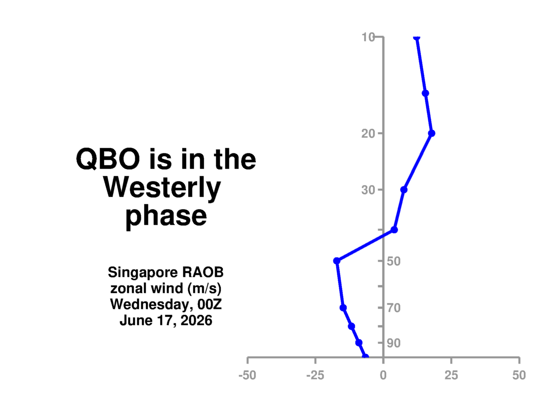
Was this the year we had multiple snow and ice storms? I seem to remember a storm (big and small) nearly every week. I wanna say this was the year that snow and ice was on the ground for what felt like the whole month of February.
-
1
-
-
Wow, pretty consistent with a lot of the members on 18z GEFS. Looking like low odds of a complete whiff. Great model agreement in general. Feeling good about this one!
-
1
-
-
That Euro snow map seems unlikely? Like just a weird look, I can not remember too many events where the valley does better than other areas.
-
According to the Mrx discussion, they are currently not buying the GFS solution. Looks like they are thinking it will play out more like the Euro/Canadian in regards to Thursday/Friday.
-
2
-
-
4 minutes ago, EastKnox said:
I'm in East Knoxville and we got about 3/4", so the map isn't terribly far off IMBY.
Nice! So seems pretty accurate. Curious what the school situation will be tomorrow.
-
25 minutes ago, John1122 said:
Last night was such an extreme situation regarding heavy rain and warm ground that any little thing was a monkey wrench. But if you got under a great band or two you racked up.
From MRX, a little broad brushed but mostly accurate imby.
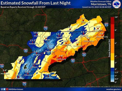
Yeah pretty accurate for me too, with an inch and a half total. Can anyone in East Knox county confirm those higher totals?!
-
1
-
-
Still have some lingering flurries here. Not adding to the totals, but makes for a nice scenic winter morning.
-
Measured an inch and a half here in Knox. Everything covered except the road. Pretty, but definitely didn't need the warning!
-
At 45 and light rain here in Knox.
-
Just curious: does the cold rain actually help with the ground temps? Seems like it would, but I don't know.
-
1
-
Jan 16-17th Boom or Bust
in Tennessee Valley
Posted
Can't say I am really that excited about this for the valley. Complex systems don't seem to work too well for us as too much can ( and usually does) goes wrong.
Looks like some warm air will find a way along with downsloping and marginal temps. I am personally not seeing it. I expect a sloppy inch here at most.