StoneColdWeatherAustin
-
Posts
136 -
Joined
-
Last visited
About StoneColdWeatherAustin

- Birthday 08/25/1975
Recent Profile Visitors
5,356 profile views


-
 It is all about perspective. If you think Brad was all over the place with the last two storms, I would love to hear what the description of the last two storm threads would be considered.
 -
Someone reach out to Tennessee and tell the people there to go outside with their vacuums and make this sucker go negative!
-
January 25/26 Jimbo Back Surgery Storm
StoneColdWeatherAustin replied to Jimbo!'s topic in Southeastern States
Everything I am reading mentions that FR has to be the predominant precip type before anything else. I assume since there is still so much up in the air right now, this is why no warnings have been issued yet. Timing is normally 12-36 hours before the precip begins. My hunch is that for most of NC, it would be Winter Storm, but it could be Ice Storm for some of the southern regions. -
January 25/26 Jimbo Back Surgery Storm
StoneColdWeatherAustin replied to Jimbo!'s topic in Southeastern States
I asked CoPilot to provide a forecast for this weekend, specifically for zip 27006. I asked it to use the latest model guidance from today. This is it's response. Seems fair. Below is a true forecaster‑style synthesis using: Global models (12Z) GFS ECMWF Canadian (CMC) Ensemble systems (12Z) LREF clusters (as directly referenced by NWS) GEFS EPS Regional / short‑range models (12Z trends where available) NAM NAM 3 km HREF (cluster signal discussed by NWS Raleigh using 12Z warm‑nose behavior) Official NWS forecast discussions using 12Z model data NWS Raleigh AFD (explicit 12Z LREF cluster interpretation) NWS Greensboro / Triad winter storm watch (timing & p‑type evolution) My Integrated Forecast (Using All Model Classes) SATURDAY — Jan 24 My Analysis of The 12Z Global + Regional Guidance All 12Z global models (GFS, ECMWF, CMC) bring deep moisture northward during the day with a strong 1035–1050 mb Arctic high wedged into NC. That wedge is seen clearly in the 12Z ensembles that NWS Raleigh noted, with all LREF clusters showing precip across the region — not a miss scenario. But the critical 12Z signal is this: 12Z LREF clusters and deterministic guidance show a warm‑nose aloft (850 mb) intruding well inland — possibly as far west as the NW Piedmont. This is the decisive factor for Advance, NC. Expected Evolution Morning: Dry but overcast. Still locked into cold CAD. Early Afternoon: Precip arrives from SW → NE. Onset likely snow, because surface temps remain mid–upper 20s. Mid–Late Afternoon: Rapid transition to sleet as warm nose strengthens. Evening: Some freezing rain possible as the warm layer deepens. My Forecast for Saturday High: 28–31°F Low: 17–20°F Snow at onset: 0.5–1.5 inches Sleet: Increasingly dominant after mid‑afternoon Freezing rain: Light glazing begins toward evening This is a sleet-forward day — not a heavy snow day — consistent with the 12Z warm-nose intrusion highlighted by NWS. SUNDAY — Jan 25 (Highest-Impact Day) Model Consensus from 12Z Runs The 12Z ECMWF remains warmer aloft than the 12Z GFS, favoring significant icing. NWS Raleigh explicitly notes: “The majority of 12Z LREF solutions indicate a warm nose making its way well inland.” This matches the track of the Miller‑B coastal redevelopment, which typically drives warm advection at 850mb over the NC Piedmont. The 12Z NAM/NAM3km tend to exaggerate CAD, but even they show warming aloft by Sunday morning. Expected Evolution Early Morning: Mainly sleet + freezing rain Late Morning–Afternoon: Freezing rain dominates as warm nose deepens (+1 to +4°C at 850 mb typical in this pattern). Evening: Precip wanes; final precip may flip back briefly to sleet or snow as column cools. My Forecast for Sunday High: 25–28°F Low: 22–24°F Freezing rain: 0.25–0.50 inches possible (locally more) Sleet: Additional 0.5–1 inch Snow: Minimal additional accumulation This aligns with NWS Greensboro’s forecast for a wintry mix including freezing rain under a winter storm watch. Impact Level: HIGH Power outages possible. Travel nearly impossible. -
January 25/26 Jimbo Back Surgery Storm
StoneColdWeatherAustin replied to Jimbo!'s topic in Southeastern States
For sure. The kicker to that is multiple globals were showing big snow for a big chunk of NC within the 72 hour window. If I remember correctly, that was Tuesday 18z, and at that time the start of the precip was roughly Friday evening or overnight at the latest. It was the 0z models a few hours later that started the real warning signs. I know it sucks for the TV people. They know all this info is shared across social media so they have to keep people in check while at the same time having no idea what the actual outcome will be until closer to 24-48 hours. -
January 25/26 Jimbo Back Surgery Storm
StoneColdWeatherAustin replied to Jimbo!'s topic in Southeastern States
I never said one model run. I said living and dying off each model run. Melting down has its own thread. I woke up this morning and read several pages of meltdowns. -
January 25/26 Jimbo Back Surgery Storm
StoneColdWeatherAustin replied to Jimbo!'s topic in Southeastern States
What I think is everyone that was posting in the wee hours of the night need to go back and read the disclaimer from Buckeye yesterday. It was some great information that will keep you in check with regards to living and dying after each model run. -
January 25/26 Jimbo Back Surgery Storm
StoneColdWeatherAustin replied to Jimbo!'s topic in Southeastern States
The words "historic", "catastrophic", "crippling", etc., have not been significant in a long time. The media uses those words like I use the bathroom. All you can do is put the information out there. -
Mid to long range discussion- 2025
StoneColdWeatherAustin replied to wncsnow's topic in Southeastern States
I cannot speak for every cold air mass this season, and would need to look at some past data, but I believe that most of them have been overdone this year. -
The HIRES NAM shows a really pronounced convective band in the gulf that appears to pull away moisture, however, the snow totals map do not seem to be affected much.
-
I would hope the school system does not try to get into the weeds of meteorology in order to make a decision on release time. Maybe that is what they do, and also the reason they make interesting decisions at times.
-
SREF Plumes currently at .46 Total QPF and 2.48 Total SNO for KGSO at 9z. Was at 2.52 and .42 at 3z.
-
Thanks. I know normally the prime placement is in the NE area funneling the air down into CAD region. I am not as familiar with seeing one sitting on the NC/GA border in a Miller A setup.
-
Can that HP placement cause any issues with bringing in warm air from the south?
-
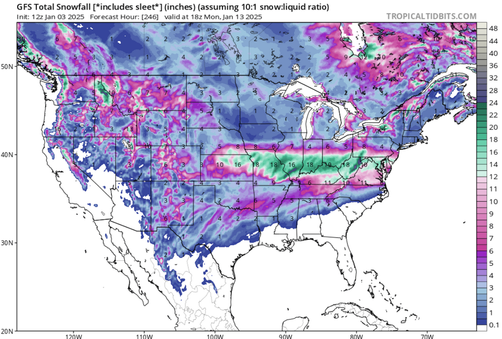
Mid to long range discussion- 2025
StoneColdWeatherAustin replied to wncsnow's topic in Southeastern States
Started at zero hour and watched this fill in through hour 246. Map was nearly blank at the beginning. Certainly a lot of this is noise, but neat to see almost the entire country covered. That would be one heck of a snow pack! I hear there is good sledding in northern Mexico this time of year...