J Paul Gordon
-
Posts
1,791 -
Joined
-
Last visited
Content Type
Profiles
Blogs
Forums
American Weather
Media Demo
Store
Gallery
Everything posted by J Paul Gordon
-
 Big flakes almost no wind. 33F/33DP still. Very pretty for November 81st (Or negative March 39).
-
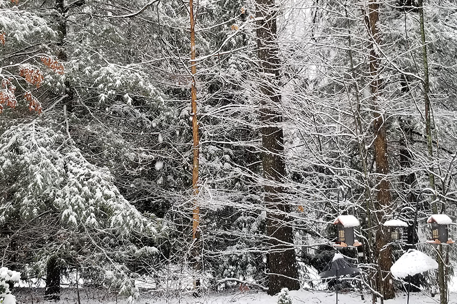
33F/33DP (just went above freezing). 2'' dense snow on the ground here and snowing steadily.
-
33F/32 DP; rain with some sleet mixed in.
-
In Clinton, MA. Maybe 2" by this time tomorrow, three if we're lucky. This is a winter when just white on the grass is a win.
-
34F, no precip here. Good luck to you guys East and SE. We've been inundated here (maybe 5" this season so far), so it's your turn to share the wealth. Seriously, hope you get a nice little hit out east tonight. Would be happy to see the ground white here in the morning. Remember Feb 2015 when we all acted like we'd been cheated if we got less than a foot? Now we're ringing the bells for 3". LOL
-
UPDATE 1/15/2023: Jan 5+ AN; Feb 0-2 AN (warm start, much colder after pattern flip, could come in colder overall if flip comes early.); March 3-5 BN (could be colder). Best chance of serious snow is, second week of Feb through end of March. Remember, this is not science, just gut feeling based on life experience. I thought we'd get killed with a mild and dry Feb. Instead we have a super mild and gray January.
-
About 2" on the grass here, maybe an inch of slop on the walk. 32F/0C. Happy Russian/Ukrainian/Serbian Orthodox Christmas Eve. Got snow on the ground for one of 'em.
-
I pick Ensemble Member 16.
-
Changing my winter "forecast" from this: Dec 3-5 AN; Jan 1-3 AN; Feb 5+AN; March 0-2 BN to this: Dec 3-5 AN; Jan 2-4 AN; Feb 1-3 AN; March 0-2 BN. Figure there may be a pattern change to lower the extreme warmth I had up earlier for Feb. None of it is scientific, but I predicted November would be 4-6 AN and it verified, likewise December should verify toward the lower end (ORH at 1.9+ after the cold spell and it is uphill from here). Snowfall? Looks like it will come in on the low side, too, but thats always a crapshoot. UPDATE: Jan 5+ AN; Feb 0-2 AN (warm start, much colder after pattern flip, could come in colder overall if flip comes early.); March 3-5 BN (could be colder). Best chance of serious snow is, second week of Feb through end of March. Remember, this is not science, just gut feeling based on life experience. I thought we'd get killed with a mild and dry Feb. Instead we have a super mild and gray January.
-
Would be great if we could squeeze an inch or two (or even a coating) of snow out of it this evening, but the chances of that look remote around here.
-
Woke up in the night to some scary blasts here. I thought they were going to take my bird feeders (things weigh about ten pounds each without food so probably closer to fifteen with food). Just pouring now temp 55F/13C
-
Still holding on to my "forecast": Dec 3-5 AN; Jan 1-3 AN; Feb 5+AN; March 0-2 BN with near-normal snowfall despite the temps. The last is really a crap shoot under any circumstances. A couple of good storms in a cold spell in January & March will do it for many. Least certain about the February torch. My Farmers Almanac approach is based on bad memories from the 70's and 80's plus AGT (Anthropogenic Torching)
-
Preliminarily ... a medium impact partial Miller B, Friday
J Paul Gordon replied to Typhoon Tip's topic in New England
Down to 35 here and radar looks like the snow is literally just a couple miles to my NW. Who knows, maybe the grass will be white in the morning. -
Preliminarily ... a medium impact partial Miller B, Friday
J Paul Gordon replied to Typhoon Tip's topic in New England
The great thing about a storm like this is the variation in temp and precipitation over a few miles. Yeah, would have liked to see all snow, but it's pretty cool just looking at some of the pictures and reading the chat. Maybe its because I'm old now, but I don't get nearly so flustered about a near miss in my backyard. -
Preliminarily ... a medium impact partial Miller B, Friday
J Paul Gordon replied to Typhoon Tip's topic in New England
Meanwhile about 12 miles to your southeast Clinton Lancaster line it has been hanging at 38-40 all day with some very heavy rain. There is definitely a 190/Rte 2 line. -
Maybe change the thread title to " We're gonna need a bigger boat"?
-
Never underestimate the Grinch. lol
-
Gonna be interesting in my new location. Lower elevation further north and east of Worcester just west of 495 (Bolton exit). If it goes over Boston it seems it will go over to rain or freezing rain for a bit here if not to all rain--maybe dryslot? Even so, if that scenario pans out the ground should be white on Christmas. Goes further west, well Welcome Grinchie lol. Still so early in the game. Could be a big hit, could be another attack of impotent rage for the weenies.
-
Aside from a lot of folks wanting an epic everything...what would be so bad about having a widespread 4-6 inches a couple days before Christmas?
-
So the Anti-Grinch Storm finally arrives! Why not call it the Father Christmas Snowblitzen (probably some thundersnow in it) on the heels of a great hit to whiten up the highlands and the north country this weekend. Even the Cape may whiten up by the end of it. Well, whatever comes of it, it doesn't look like a classic Grinch event on the horizon, but it most certainly looks like a fun week ahead as the hysteria increases the closer Santa gets. Will he bring presents to cheer the snow lovers or a muddy glob in the stocking? Only time will tell.
-
Preliminarily ... a medium impact partial Miller B, Friday
J Paul Gordon replied to Typhoon Tip's topic in New England
Was surprised that anyone south of Rt 2 and East of the Berkshires ever seriously thought this would pan out to more than an inch (if we are lucky to get that much). Be nice to get a surprise, but I'm not holding my breath. It was nice to have a couple of days of fairly solid cover here. Is there more hope just before Christmas? Anyhow, happy for folks to the north and west. Not going to whine about getting left out. It's even less productive to complain about the weather than it is to mope about politics. -
I'm sticking by my winter "forecast", based on a lifetime of experience (3-5 AN Dec, +1 to -1 Jan, 5-8 AN Feb, 1-2 BN March with near normal snowfall due to a few good hits in cold spells). Who knows, the annual grinch storm may end up being a whiteout just to soften the heartache. lol
-
ORH 78; BOS 54; PVD 48; BDL 56; CLT (Clinton lol) 65 same guess for BED
-
ORH 78; BOS 54; PVD 48; BDL 56; CLT (Clinton lol) 65 same guess for BED
-
Seems like the Winter 022-023 page is pretty much defunct. I put this up in mid-November and I'm still feeling pretty good about it verifying overall. Don't ask for precise analogs; it's mostly just perception based on living here all my life and experience with torchy Novembers. Just for fun. Maybe a tad too AN for December but we'll see. Snowfall may not be so bad in between Lakes runners and big warmups. Maybe 2-4 AN December with spells in the mid to upper fifties instead of sixties. Guesses based on previous winters that start with a very warm November. Unscientific but probably more likely to pan out than the Old Farmers Almanac. Nov: 6-8 AN; Dec: 4-6 AN; Jan: 1-3 AN; Feb 5-8 AN; March 0-2 BN. In December we'll have some cold snowy outbreaks but a couple of multi-day spells of very high temps (generally low to mid-60s) will skew the month much above normal. The annual "grinch storm" is likely on the ticket. January will be closer to normal with a couple of inland runners with mild, rainy weather and maybe a coastal that will bring snow to much of the interior (and coast Boston northwards); February will be very mild and dry. Normal to below normal temps in March with significant snowfall throughout the region except for the Cape and islands.


