T. August
-
Posts
4,612 -
Joined
-
Last visited
Content Type
Profiles
Blogs
Forums
American Weather
Media Demo
Store
Gallery
Everything posted by T. August
-
Euro is great for DC-SE. 7-8” all the way to southern MD
-
Not only that, but the individual panels are eerily uniform. Almost no variation in track or strength. I wonder how useful they truly are for precipitation.
-
Partially storm related, but the 18z gfs and 12z euro are below freezing for most of the area until the end of the runs. Absolutely insane. Whatever falls will be here when we flip the calendar.
-
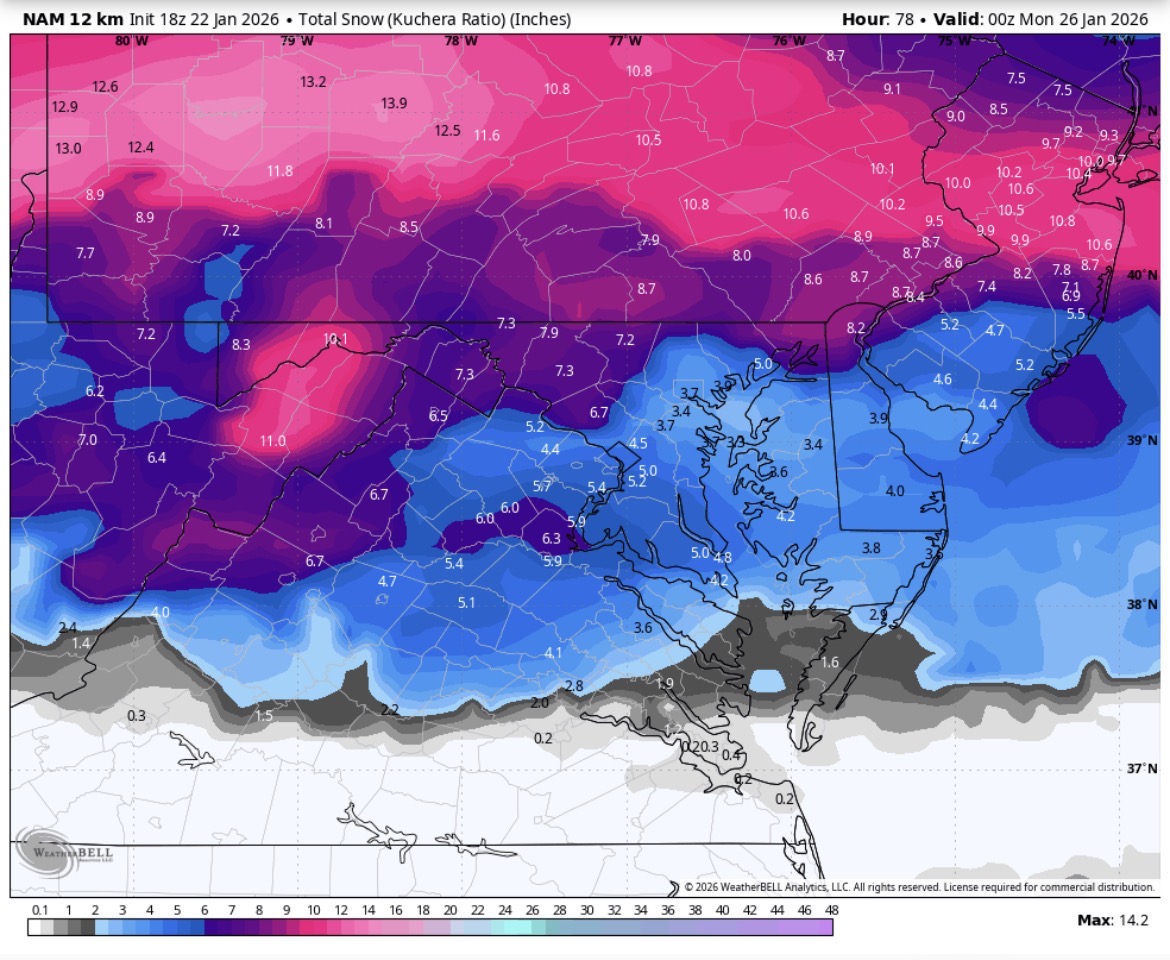
Kuchera is dastardly

-

January 24-26: Miracle or Mirage JV/Banter Thread!
T. August replied to SnowenOutThere's topic in Mid Atlantic
Nam was a disaster for sure -
I believe they lean on the NBM heavily especially 3 days out. I’m sure @high risk can correct me lol
-
January 24-26: Miracle or Mirage JV/Banter Thread!
T. August replied to SnowenOutThere's topic in Mid Atlantic
Hopefully we are converging on a result that is close to reality. As it stands I feel like 6-9” is a safe and reasonable forecast for 95. Feel like 10-14” NW. -
0z eps looks good to me. Really not too different. A bit more qpf.
-
12” in DC on the Kuchera
-
So close to all snow in dc. Just misses the pivot by 30 miles
-
It is indeed south of 18z through 90
-
It’s lowkey good. Mix line actually stops advancing for a panel.
-
January 24-26: Miracle or Mirage JV/Banter Thread!
T. August replied to SnowenOutThere's topic in Mid Atlantic
I think all of our warm layers are bare ass naked right now. We should focus on hiding them. -
Qpf. That’s why DC’s total at 10:1 is on the way to putrid.
-
January 24-26: Miracle or Mirage JV/Banter Thread!
T. August replied to SnowenOutThere's topic in Mid Atlantic
Almost disaster territory. 10:1 map was depressing. -
DC loses .6” of precip due to non snow precipitation
-
I believe it was 0z 1/22 (tonight)
-
Yeah but 12z GEFS had a lot of misses to the south.
-
Wxbell is snow through 96 at least
-
GFS starts snow in DC at 7pm Saturday
-
I was gonna say - it looks like it starts to phase before getting on shore. Wxbell is behind, but hr71 looks primed (in a good way).
-
January 24-26: Miracle or Mirage JV/Banter Thread!
T. August replied to SnowenOutThere's topic in Mid Atlantic
-
I think I gave a pretty accurate description without seeing the final maps. M/D line around 5-6”
-
In DC it’s workable but anywhere north, the warmth outraces the precip. Still waiting on final maps but I’d say north of Baltimore is 5-6” at 10:1 (which honestly they might be lower ratios).
-
Literal disaster. Dry front end then a flip to zr