
jjwxman
-
Posts
343 -
Joined
-
Last visited
Content Type
Profiles
Blogs
Forums
American Weather
Media Demo
Store
Gallery
Posts posted by jjwxman
-
-
The word "Historic" should only be used during or after an event IMO. 4/16/11 was historic.
-
 3
3
-
-
45 minutes ago, Cold Rain said:
Strongly agree with all of this.
But the 12z NAM suite just made a case for the moderate risk...
 Geez look at those backing SE Surface winds. Increased surface cape as well, slower with the system.
-
For the Carolinas: I don't think we'll see a Moderate Risk. (but what do i know
 ) There are few things that will plague this forecast. 1st. The influx of tropical moisture will likely cause a warm layer around the 700-500mb level, this will weaken the mid level lapse rates. 2nd. The whole column looks very tropical, there will likely be a lot of cloud cover so CAPE will be limited. 3rd. PW values will likely be at record territory for this time of year, and with the slow progress of the system west to east, flooding will probably be the forefront of this event from training storms. I wouldn't be surprised to see some 2-4" rain totals in some areas. 4th. If we do see some sun and decent destabilization then this could turn out to be a significant severe weather event, particular for damaging winds, the hodographs are more elongated than curved, so the tornado threat should remain isolated in nature unless we get more backing from SE surface winds. A lot to decipher over the coming days.
-
3
-
-
8 minutes ago, Solak said:
RAH: 10:50AM
Some caveats to this set-up will be: a.) low stratus deck this
morning is inhibiting heating. If this low cloud deck is slow to
dissipate, this will inhibit heating later this afternoon, resulting
in lower than expected available instability; b.) 12Z GSO sounding
depicts a rather thick layer of warm air between 850-700mb. Model
projections suggest this layer becoming cooler late this afternoon
with the approach of the mid level perturbation. If this fails to
materialize, the presence of this warm layer will inhibit convection
depth/development; c.) lack of a low level boundary to focus
convection and enhance low level shear/helicity.
That's good analysis from RAH. The sun is beginning to break through now in south Greensboro, seeing some blue sky finally.
-
40 minutes ago, olafminesaw said:
Seems awfully wedgy this morning for severe. But there's time to clear out a bit I suppose.
It want be long until the sun starts to break through.
-
Here's the 12z HRRR sounding over central NC at 20z. Storms begin to initiate shortly after this sounding at 21z. Damaging winds, and hail seem to be the main threats. Wouldn't rule out a spin up on the more discrete cells that form ahead of the main line of convection.

-
Where the heck was this in Jan and February... lol, What Beautiful set up... The 12z Euro was just a hair too warm this run.

-
1
-
-
Trying my best to not get sucked in....
-
 1
1
-
-
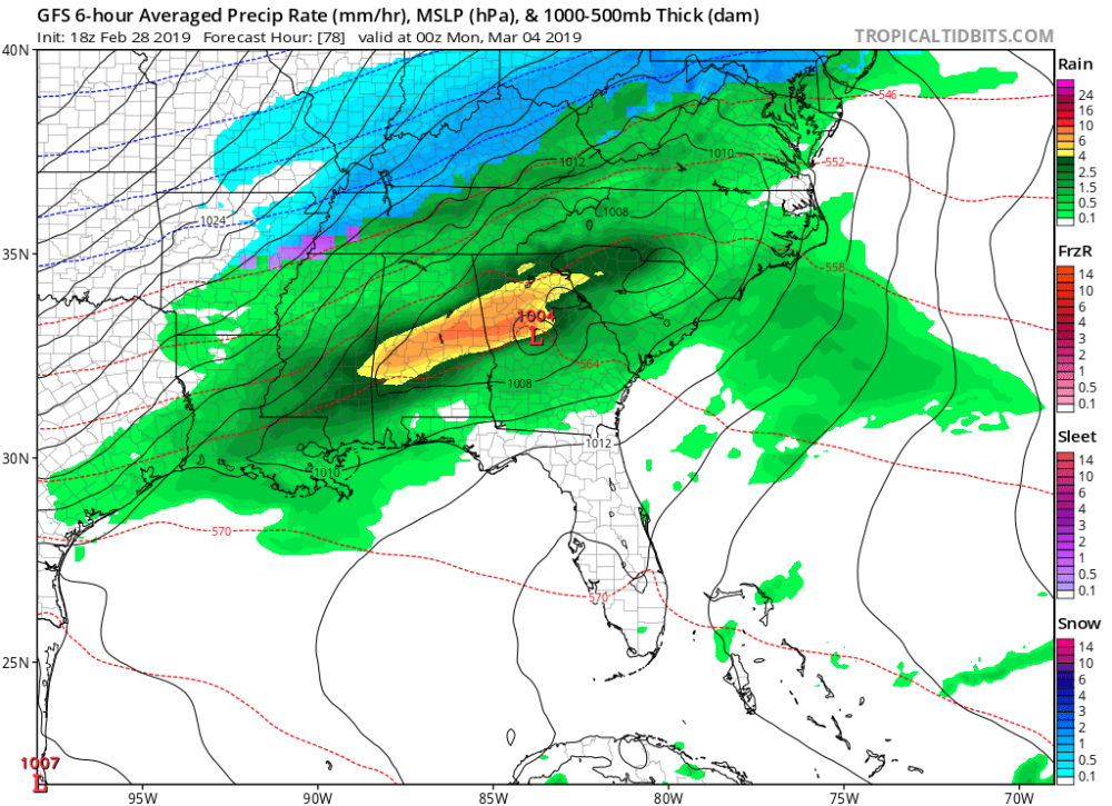
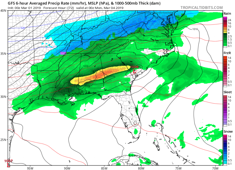
The 00z GFS has the LP considerably further south than the 18z run. Probably nothing, just intriguing to me.
-
22 minutes ago, mackerel_sky said:
You mean we are not going to get 2 blizzards next week? When did this happen? Last I heard , the Euro, GFS, and GFSv3 all had snow! Don’t tell me they were wrong???? Just like the whole winter!
Shocking isn't! Glad I held on to my big grain of salt! Ha!
-
Ha, the Euro now has temps in the mid 60's over central NC with thunderstorms Sunday evening/night. Ugh..............
-
3 minutes ago, mackerel_sky said:
I wouldn’t want to be in the bullseye 7 days out! Plenty of time for this to trend North, and be a mid Atlantic special
Exactly... we've seen this all Winter long from one model or another. In this case most of the globals show the storm system, which is encouraging, but I'm holding on to my big grain of salt for now. Lol
-
This thread is now "hot".... Must have been a nice 12z model suite! Let's finish Winter 2018- 2019 strong!
-
CAD also has big implications to the forecast in regards to severe weather in the Spring. Over the years I’ve seen the SPC really struggle with their outlooks because of an “overperforming” CAD, particularly in the Piedmont of NC.
-
1
-
-
Mostly Sleet, some flakes mixed in at times in Randleman, NC.
-
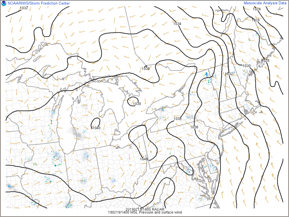
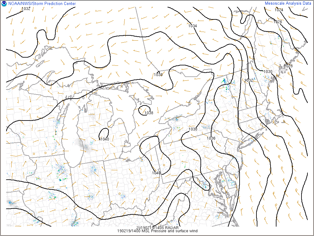
Current analysis now shows a 1040mb center of HP over OH/PA state line. Let's see what happens this afternoon in regards to temps/dewpoints.
-
1
-
-
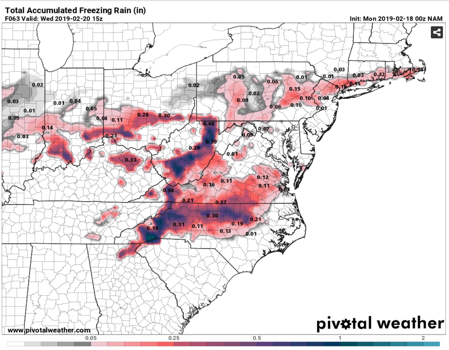
12z NAM Soundings in Greensboro and Winston at the initial thump of precip look to be a rain snow mix, if not all snow if the precip is heavy enough, and all snow west and north of Winston. Of course that changes very quickly to rain/freezing rain overnight.
-
Enjoy this eye candy while it lasts...

-
1
-
-
This will be a very minor event outside the Mountains and Foothills. A glaze of .01-.05 is possible in the Triad, but I don’t expect more than that. With very marginal temps, roads should remain wet for the NW Piedmont. This is another Mountain/Foothills ice event, like the 5th or 6th this Winter season.
-
That HP is in a great spot for a CAD special.

-
10 minutes ago, Rankin5150 said:
This far out, it is a good look. The problem is...it is the 8-10 day conundrum, which we cannot get past. Tomorrow, it will be gone again. GRRR...
Well at least it's not just the FV3 on board this time, there's actually some support from the globals. Something watch, but yea wouldn't surprise me at all to see it go poof!
-
1
-
-
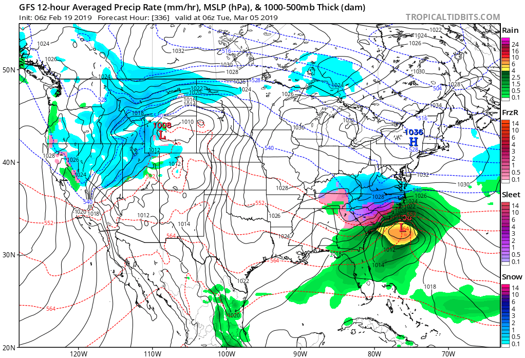
GFS-FV3 now with 4-5 consecutive runs of a significant winter storm for the CAD favored areas of NC/SC/N GA. 150 hrs out... So hard to trust this model though.

-
2
-
-
The 32 hr 12z HRRR also has no snow east of the Apps. In fact it has temps in the mid to upper 40’s on the back end of the precipitation.
-
This is a classic case of cold air chasing moisture I'm afraid... and we all know how that works out east of the Apps. If we see snow it'll be a big win, no matter the amounts.
-
3
-

General Severe Weather
in Southeastern States
Posted
Regardless, I'm not sure if I've ever seen wind speeds this high above the surface over NC. Incredible. Lots of potential, but like @downeastnc said the bust potential is high as well.