
jjwxman
-
Posts
343 -
Joined
-
Last visited
Content Type
Profiles
Blogs
Forums
American Weather
Media Demo
Store
Gallery
Posts posted by jjwxman
-
-
We’ve all seen this before, the GFS is always the first on the table, mainly because it runs 15 days, then loses it, then brings it back within the 3-4 day timeframe. But let’s forget that 12z GFS, how about that 12z CMC run?!!
 lol
lol
-
 3
3
-
-
00z Euro... Nice.


-
5
-
 1
1
-
-
2 hours ago, Waiting on snow said:
Hideous run on the FV3 also. Low goes from north MS to off the ne coast.
How does FV3 figure this will happen from that run? Lol
-
 1
1
-
-
1 minute ago, SnowNiner said:
Looking forward to getting at least one Euro op crush job to make this feel real. The ensembles looking steady has my mind confident, but I need a nice clown map from the EURO to confirm this has a shot. You would think we could get at least one here and there the way the ensembles look.
Yeah, I'm with you there.
-
1 minute ago, Solak said:
That Wednesday system could be a sneaky system. Got to watch that too.
-
12Z EPS stays on the more southern route.


-
1
-
-
"Control" yourselves! Lol. The EPS did stay on the more southern route, which is encouraging. Does anyone have the control map they can share?

-
Both GEFS and EPS were further south than their respected operational runs. Hope remains alive for now.


-
The wind has really picked up in South Greensboro now as the back end precip pivots back southeastward. Gusting to 30-40.
-
Hickory reported a wind gust of 38 mph at 12:23pm. So there is some verification of strengthening winds behind Michael, we'll see how high they go.
-
New Tornado watch coming soon to portions of central and eastern NC.

-
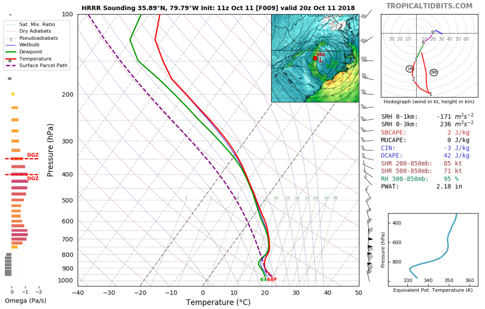
24 minutes ago, fountainguy97 said:
Yeah its hard to believe the high res. But lets check into their verification. So far the 06z HRRR run has verified in most places with its wind gusts within 5-10mph.
Something else I have noticed in the past with the HRRR is that it usually locks in rather firmly in the 8-10 hour mark. And that normally happens by way of a big trend in the 14-8 hour range.
Here is the latest 5 runs of the HRRR:

We will see what comes of this. But that is a very obvious and large trend back to some impressive wind gusts.
From what I can see, and correct me if I'm wrong, The losest 100 mb on the latest HRRR sounding goes Dry Adiabatic on the backside of Michael allowing 50+ kt wind gusts to mix to the surface.
-
TS Warnings are now up for most of NC. Heavy rain bands with lightning moving through Randleman now. (15 miles south of Greensboro)

-
1
-
-
Something to keep in mind is there will be dry air intrusion going on with the arrival of the front on the west side of Michael. That could help mix down stronger winds to the surface. The latest runs of the NAM 3km and the 12z HRRR picked up on that nicely. Also the NWS RAH mentioned that as well in their latest briefing.
-
2 minutes ago, kvegas-wx said:
Because of course he did. Hype machine in full effect. Whether it's winter with 2 foot snow storms or tropical armageddon, it makes headlines. Not saying he's wrong, but I don't see it anywhere else....yet. Not sure how he can always be "first to know" on literally all things weather.
He's basing it off of the extrapolated pressure of 915 mb... which is nowhere in the data file that I can see... Last pass was 919 mb
-
1 minute ago, WeatherHawk said:
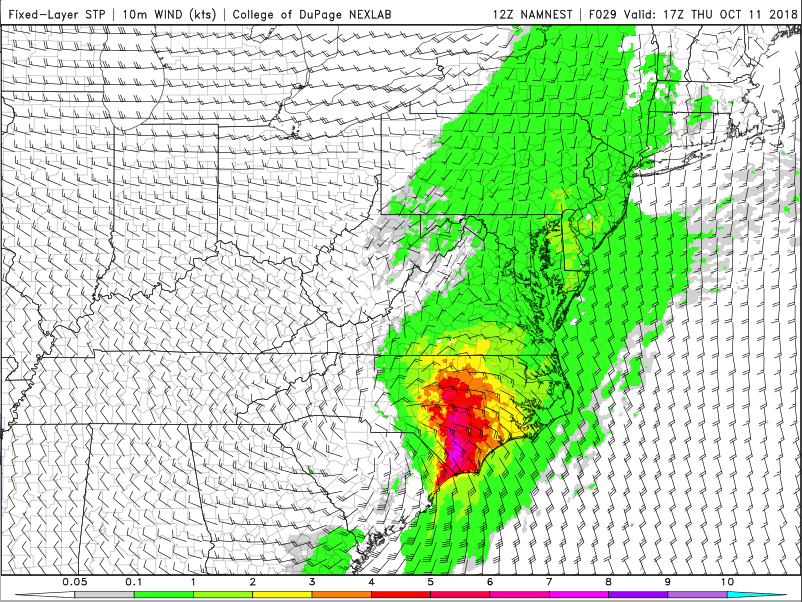
Haven't heard much talk about the threat of tornados...
STP for Thursday afternoon. Big threat IMO.
-
This is the most impressive I've seen the satellite imagery. Not good.

-
1
-
1
-
-
2 minutes ago, jrips27 said:
Agreed.
Here is new 12z Euro max gusts from 5-8AM Thursday morning. These gust maps are inflated and that has been well documented on this board. It's probably a good idea to take 15-20% off the given max value to get a realistic idea of what would actually happen if the Euro is correct. Still that paints a widespread 60mph+ area across central/southern GA
https://weather.us/model-charts/euro/georgia/gusts-3h-mph/20181011-1200z.html
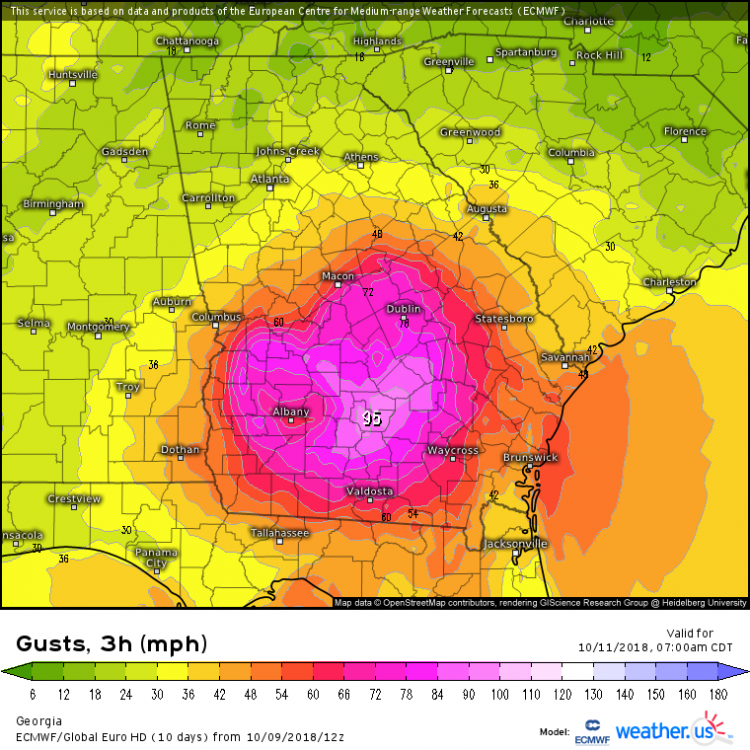
These maps were about 15-20 mph overdone in Florence. Still, 70 mph wind gusts are nothing to talk down.
-
The 12z Euro was actually a little further west and north this run compared to the 00z. But the impacts remain the same.
-
So how about this forecast for Greensboro from RAH... is this their way of telling folks not to let their guard down? Seems a little over the top to me based on the forecasts... Thoughts?
-
1
-
-
Many areas in western NC have already had a surplus of rain this year. A stalling hurricane plus strong wind gusts over this area would be terrible. Let's hope against that outcome.
-
1
-
-
That would be devastating for the OBX, ENC, and SEVA.
-
The 12z NHC track continues the shift SW. Carolinas in the sites now.
-
CWASP Percentages via the 6z NAM on Sunday afternoon.

-
1
-
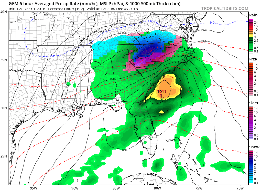
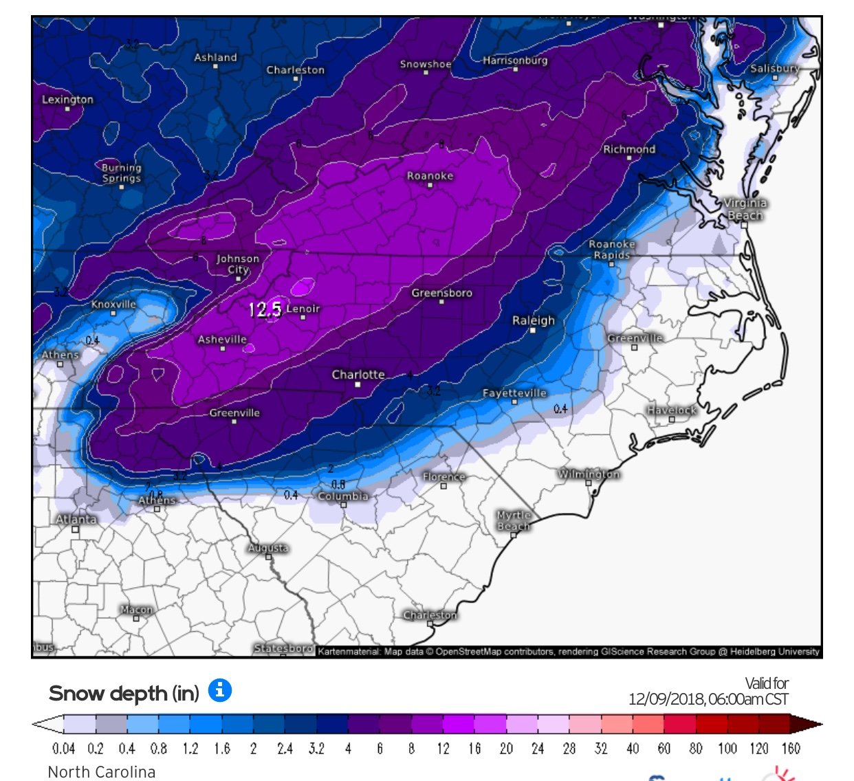


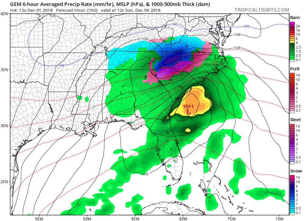
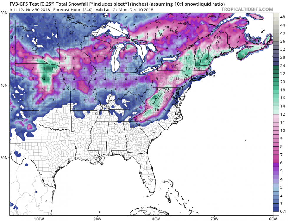
December 8-10, 2018 Winter Storm
in Southeastern States
Posted
Taken verbatim the GFS drops 6-8 over the Triad before it changes to rain... But I’m not so sure I buy the switch over to rain along and west of the I-85 Corridor. Who knows...