
jjwxman
-
Posts
343 -
Joined
-
Last visited
Content Type
Profiles
Blogs
Forums
American Weather
Media Demo
Store
Gallery
Posts posted by jjwxman
-
-
26 minutes ago, NCSNOW said:
0z Nam trending wrong direction;

That’s more like a leap in the wrong direction compared to the 18z. Ouch.

-
21 minutes ago, SteveVa said:
I'll always be skeptical about rain to snow scenarios following a cold front. In our neck of the woods we tend to run out of precip before sufficiently cold air arrives. The Arctic front a couple of days ago was supposed to be rain-snow but precip ended before we even got to 40.
Here in the NW Piedmont of NC it hardly ever works out because of downslope. There has to be a secondary trigger like a wave of LP or an upper air disturbance to wring out any left over moisture. I'm not sold yet.
-
 2
2
-
-
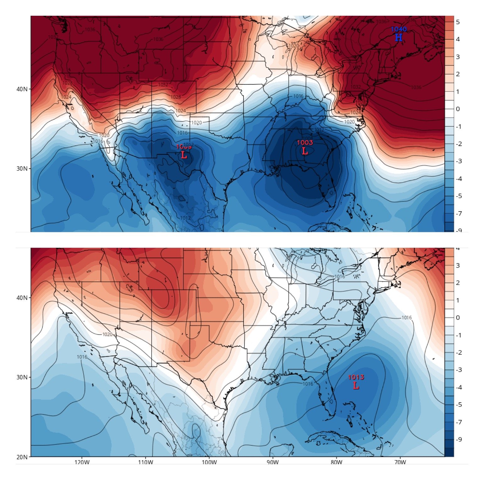
While we got a long ways to go, maybe just maybe this will turn into something. The CMC and Euro showing at least some potential in the Day 9 time frame. Would love to see the EPS have this closer to the coast. 12z Euro below:

-
24 minutes ago, mackerel_sky said:
Let’s discuss this mini ice situation Tuesday night?? Man it’s cold and dry out! NE winds still stiff! How’s the hi res models looking?
18z NAM taken verbatim, in GSO freezing rain Wednesday Morning with temps near 30, by Midnight temps could warm to near 60 degrees.... Ok, Gotta love it.
-
Great Euro run... but man I wish we were talking 5-6 days and not 9-10. But hey the CMC had this storm as well, so there's that.
-
1
-
-
Swing and a miss for the 12z GFS (old). Give it time...

-
Just now, SouthCentralWakeCo said:
18z GFS for next Thursday
That's the 12z CMC.
-
1
-
 1
1
-
-
1 minute ago, mackerel_sky said:
Think the CMC was overdone with the last frozen event a few Saturdays back! It was constantly the coldest and most robust with frozen
The RGEM was way overdone on cold and precip on the 12-13th event.
-
FWIW: 1/25/19. 12z OP GFS vs 12z GEFS.

-
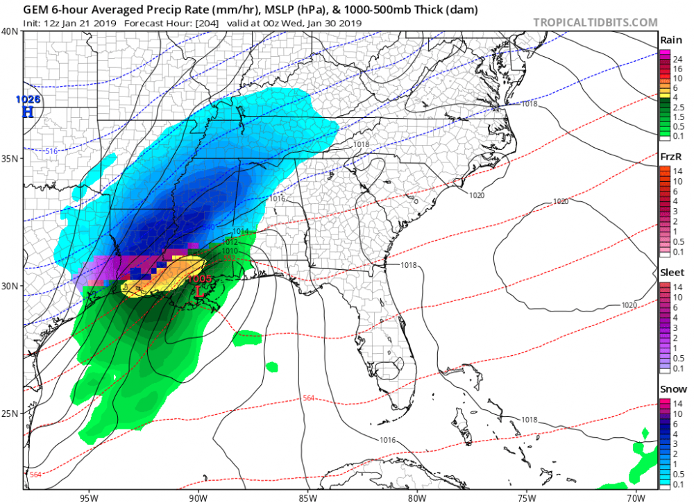
The Triad is now transitioning to freezing rain. 31 in W-S, 32 in GSO.
-
12z HRRR...


-
The morning 6z NAM products and 12z HRRR is making this more of an I-40 and north event. The 12z HRRR will make most jump ship if you are south of I-40.
-
8 minutes ago, Orangeburgwx said:
I'm already at my low... Currently 32...
Same here just south of Greensboro. 28/17
-
It’s currently 28/15 south of Greensboro in Northern Randolph County. High clouds just beginning to move in.
-
3 minutes ago, Gibby said:
Looks like totals are lower on the 18z NAM

I think they actually ticked up along and north of I-85. I wouldn't be surprised to see RAH put Davidson, Forsyth and Guilford in the Winter Storm Watch.
-
17 minutes ago, SnowDawg said:
Nowhere close to what’s forecast in upstate and N GA. Which is why this is still so hard to give any credence to.
I should have said in the Western Piedmont of NC... my bad.
-
Just now, mackerel_sky said:
GSP says that warning criteria could be reached, too much uncertainty at this point
The 12z RGEM is absolutely ridiculous on the ice. Major Ice Storm in the CAD favored areas.
-
The 12z NAM 3Km is more believable and more inline with local forecasts.

-
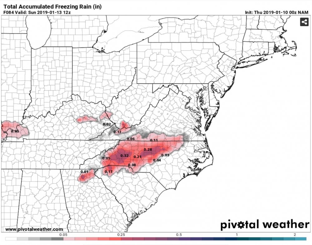
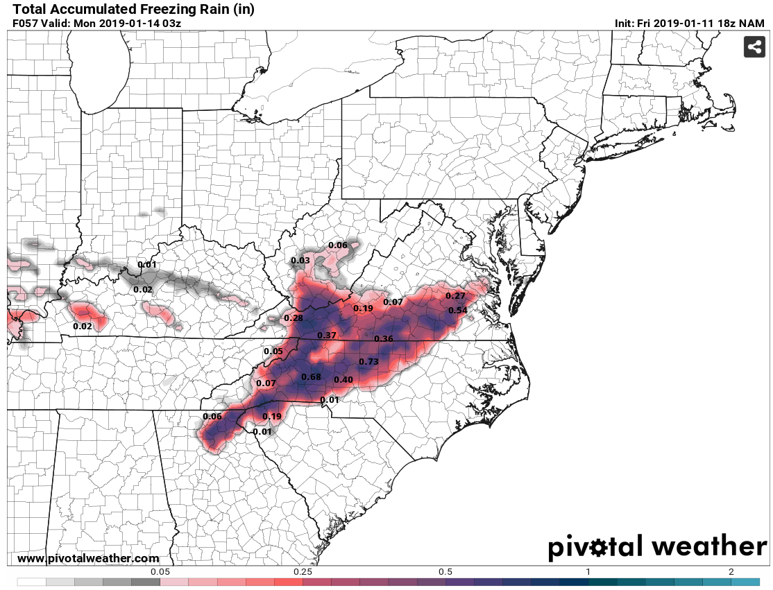
12z NAM Total Accumulated Freezing rain. I'm not aware of any WFO's or media outlooks mentioning the possibility of an Ice Storm. Just Social Media chatter at this point. Let's see what the other 12z data shows. I know the NAM does well with temp profiles, but I'm not sure about precip rates.
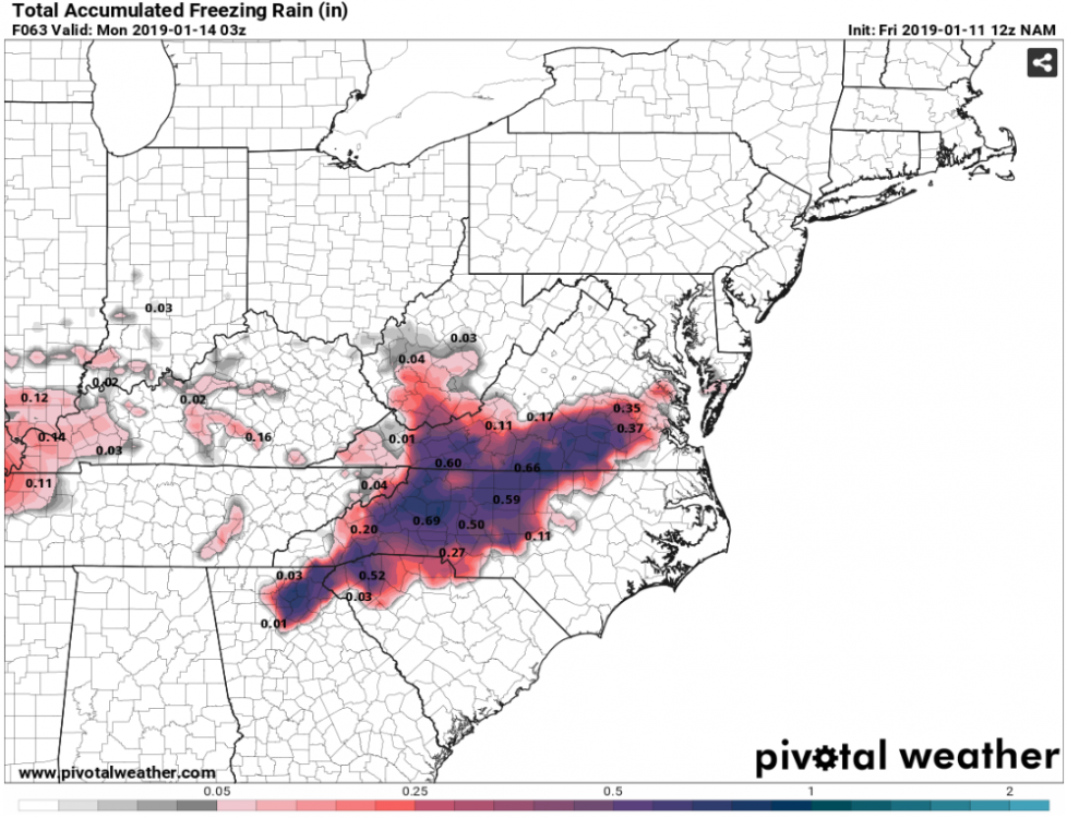
-
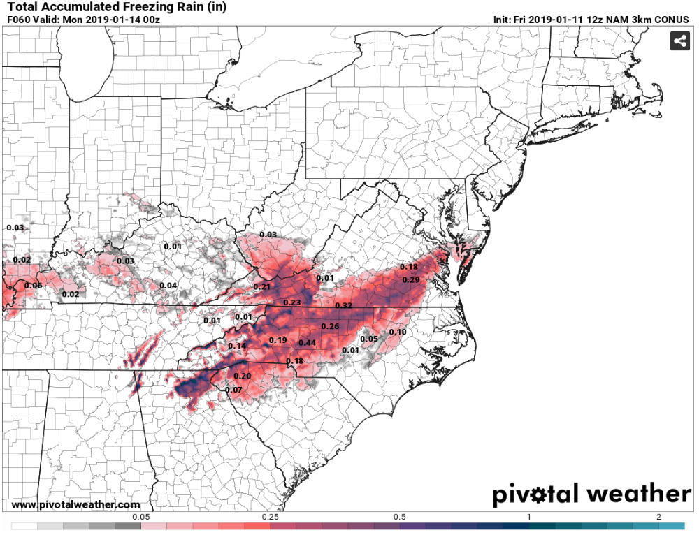
00z NAM freezing rain totals through 7am Sunday. I-40 Corridor looks to be the zone for best icing right now.
-
11 minutes ago, FallsLake said:
So the 18z ICON is a nice hit for central VA to the MA. It looks like there would still be some big ice totals in the western foothills and NW Piedmont.
Edit: It does create some backside snow (Monday) as talked about...
Yea the Icon doesn't output IP,ZR. If you look at the surface temp maps, favored CAD areas are below freezing during the event. ICON also has the secondary wave of low pressure on Monday.
-
2 minutes ago, Cheers for Western Ears said:
Is anyone concerned with what the Nam is showing? I realize it is well outside of it's range but still..
Concerned as in it looks awfully north?
-
1
-
-
Pivotal now has skew-T plots for the CMC. Classic Ice Storm over Central NC at hour 138. Just one of many outcomes still on the table.
-
Geez, I'd take 33 and rain over the apocalyptic ice storm the CMC has. Drops 1.50-1.75" qpf over the I-85 corridor which remains below freezing for the event.


Post Arctic front snow Tuesday, Jan 29
in Southeastern States
Posted
Thundersnow anyone? With those steep LR’s it’s possible! Sounding taken over the Triad.