Jump to content

MoistWx

Meteorologist
  • Posts

    89
  • Joined

  • Last visited

About MoistWx

Profile Information

  • Four Letter Airport Code For Weather Obs (Such as KDCA)
    KSLC
  • Gender
    Not Telling
  • Location:
    Utah

Recent Profile Visitors

1,818 profile views
  1. Yeah... can someone else take one for the team on this one? I can throw in some boudin and crawfish to sweeten the deal lol. Pretty sure the city just came by recently to do their "last" round of debris pickup for Laura/Delta.
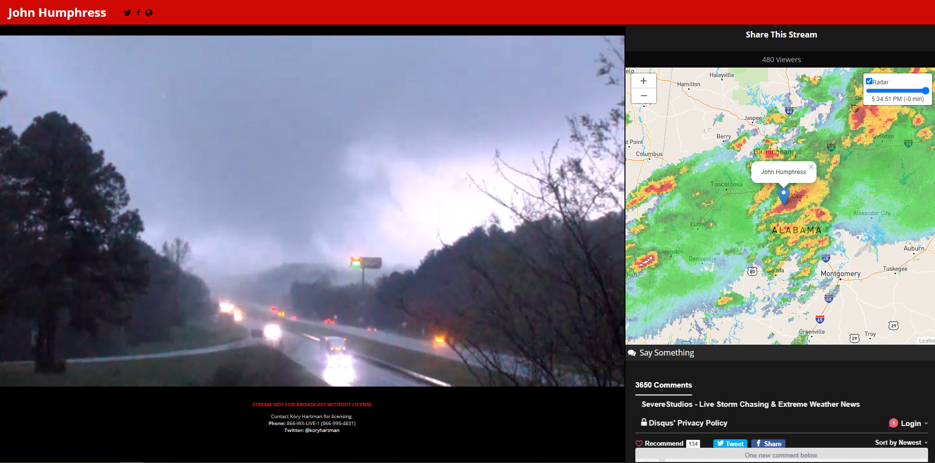
  2. Not the best SS of it, but wow. Thing is a monster.
  3. Oops... Yes, good catch. That's what I get for posting while also being in severe weenie mode
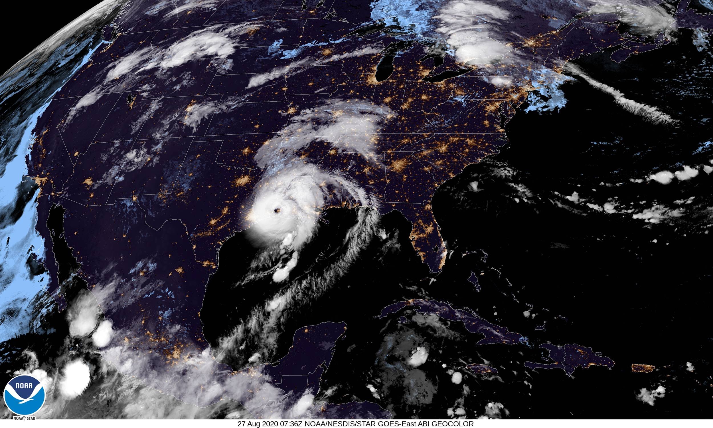
  4. According to the WMO, the names Dorian, Laura, Eta and Iota from the 2020 Atlantic Hurricane Season have been retired. The Greek alphabet will no longer be used for future hurricane seasons, and a supplemental name list will be used in its place. Interesting. https://public.wmo.int/en/media/press-release/wmo-hurricane-committee-retires-tropical-cyclone-names-and-ends-use-of-greek
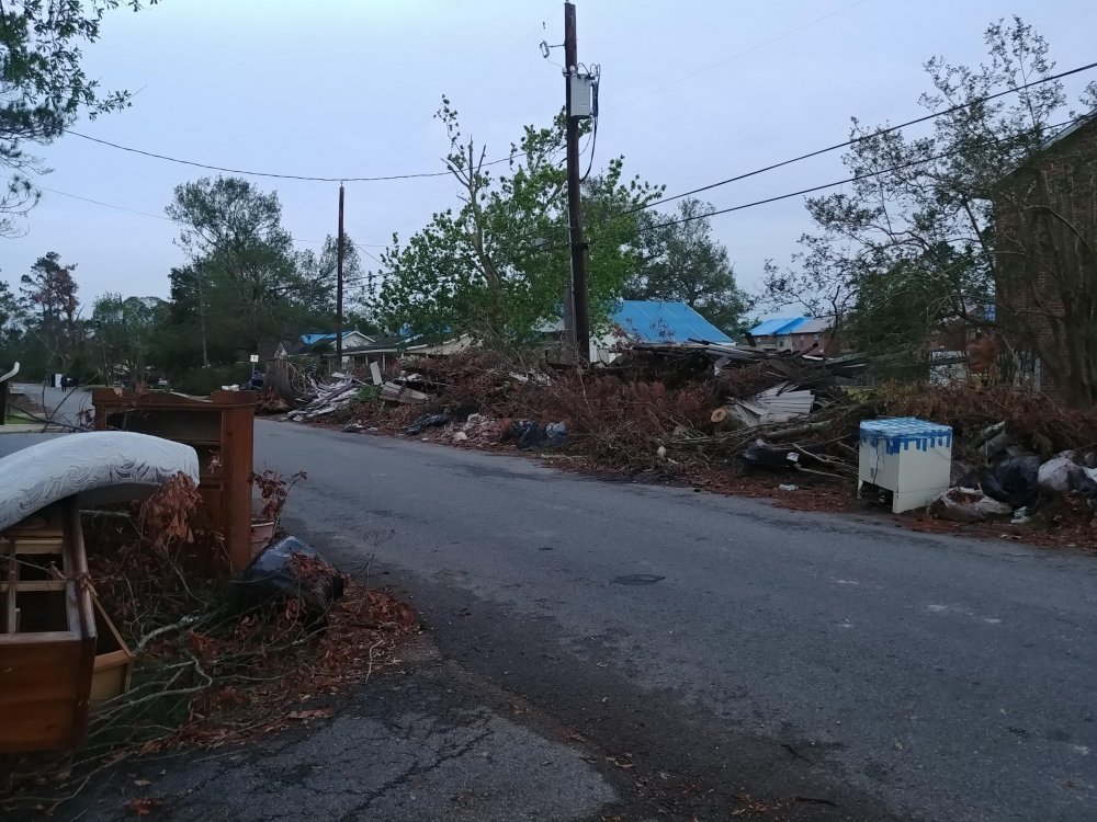
  5. For anyone wondering, this is what the majority of roads in Lake Charles look like at the moment. I assume the surrounding cities that were impacted look similar as well. Debris pick-up was starting to make progress on some of the more busy roads, but just barely. Mostly only semi-cleared on the main arteries. It was nice having north facing windows for a bit I guess? .
  6. With a large pile of debris in eyeshot of my apartment and a tarp on the roof (the normal around the city right now), yeah, can confirm I'd rather not have this one.
  7. Interesting. Wasn't really expecting to see a mid-day day 3 update come out.
  8. Last couple of HRRR runs want to push an isolated cell through Central LA overnight with the warm front retreating north. Cant think this would really cause too many problems with the overall environment... But wonder if it could leave some remnant mesoscale boundaries that could persist until initiation time tomorrow.
  9. 6 more tornadoes surveyed by LCH today too per the PNS. I believe LIX and SHV might have confirmed a few more as well. Public Information Statement National Weather Service Lake Charles LA 830 PM CDT Fri Nov 2 2018 ...NWS Damage Survey for 10/31/18 and 11/1/18 Tornado Event... .West Bundick Lake Tornado... Rating: EF-1 Estimated Peak Wind: 107 MPH Path length /Statute/: 1.5 Miles Path width /Maximum/: 280 Yards Fatalities: 0 Injuries: 0 Start date: OCT 31 2018 Start time: 940 PM CDT Start location: 10 SE DeRidder/Beauregard/LA Start Lat/Lon: 30.7193 / -93.2022 End date: OCT 31 2018 End time: 943 PM CDT End location: 9 SSE DeRidder/Beauregard/LA End_lat/lon: 30.7389 / -93.1926 Survey Summary: A tornado snapped several trees along Chester Davis Road, northeast to Lumas Road. .Southwest Sugartown Tornado... Rating: EF-1 Estimated Peak Wind: 104 MPH Path length /Statute/: 2.6 Miles Path width /Maximum/: 300 Yards Fatalities: 0 Injuries: 0 Start date: OCT 31 2018 Start time: 1143 PM CDT Start location: 6 SW Sugartown/Beauregard/LA Start Lat/Lon: 30.8151 / -93.1132 End date: OCT 31 2018 End time: 1146 PM CDT End location: 4 SSW Sugartown/Beauregard/LA End_lat/lon: 30.8140 / -93.0702 Survey Summary: A tornado started east of Rutherford Road, and moved across Vaughn Road, ending near Smyrna Road. Several trees were snapped. .Oakdale/Turkey Creek Tornado... Rating: EF-2 Estimated Peak Wind: 118 MPH Path length /Statute/: 13.3 Miles Path width /Maximum/: 900 Yards Fatalities: 0 Injuries: 0 Start date: NOV 01 2018 Start time: 1217 AM CDT Start location: 1 S Oakdale/Allen/LA Start Lat/Lon: 30.7914 / -92.6606 End date: NOV 01 2018 End time: 1233 AM CDT End location: 4 NW Turkey Creek/Evangeline/LA End_lat/lon: 30.9027 / -92.4782 Survey Summary: A strong tornado started south of Highway 10, and as it crossed the highway it snapped several power poles. The tornado then moved down Cypress Creek Road, where it snapped numerous trees and power lines. In Evangeline Parish, it moved from Cypress Creek Road to Cypress Road and Red Lick Road, before dissipating south of the Rapides Parish line. Many trees and power lines were down. .Hessmer Tornado... Rating: EF-2 Estimated Peak Wind: 122 MPH Path length /Statute/: 13.6 Miles Path width /Maximum/: 800 Yards Fatalities: 0 Injuries: 0 Start date: NOV 01 2018 Start time: 1250 AM CDT Start location: 2 SE Cheneyville/Rapides/LA Start Lat/Lon: 30.9874 / -92.2640 End date: NOV 01 2018 End time: 106 AM CDT End location: 4 NE Hessmer/Avoyelles/LA End_lat/lon: 31.0786 / -92.0629 Survey Summary: The tornado started near US Highway 71 near Cheneyville, snapping several power poles. As it moved northeast, it blew down many trees and power lines. The most significant damage was to a new home on Bordelon Road, built of steel beams and metal sheets. A large roll up door was blown in, and picked up an outside AC unit, tossing it into the garage. The steel beams were bent in three-fourths of the building. Half of the metal roof was blown off, and what remained shifted several inches. One exterior wall shifted several inches. Several other homes on Bordelon Street had part of their roofs removed. Many trees were snapped and power lines were downed. Tree damage was noted on Highway 115 south of Hessmer, and the tornado dissipated before it reached Highway 1 in Mansura. .Russells Landing Tornado... Rating: EF-1 Estimated Peak Wind: 107 MPH Path length /Statute/: 9.9 Miles Path width /Maximum/: 350 Yards Fatalities: 0 Injuries: 0 Start date: NOV 01 2018 Start time: 113 AM CDT Start location: 4 ENE Marksville/Avoyelles/LA Start Lat/Lon: 31.1468 / -91.9918 End date: NOV 01 2018 End time: 127 AM CDT End location: 14 NE Marksville/Avoyelles/LA End_lat/lon: 31.2513 / -91.8780 Survey Summary: A tornado started in remote areas east of Marksville, and moved across Lake Ophelia Wildlife Refuge, where numerous trees were blown down or snapped. At Russells Landing, many trees were blown down or snapped. One landed on an RV. The tornado dissipated northeast of that region in the wildlife refuge. EF Scale: The Enhanced Fujita Scale Classifies Tornadoes into the following categories. EF0...Weak......65 to 85 MPH EF1...Weak......86 to 110 MPH EF2...Strong....111 to 135 MPH EF3...Strong....136 to 165 MPH EF4...Violent...166 To 200 MPH EF5...Violent...>200 MPH Note: The information in this statement is preliminary and subject to change pending final review of the events and publication in NWS Storm Data. And the other: "Public Information Statement National Weather Service Lake Charles LA 241 PM CDT Fri Nov 2 2018 ...NWS Damage Survey for 11/01/18 Tornado Event... .Iowa Tornado... Rating: EF-1 Estimated Peak Wind: 90 MPH Path length /Statute/: 0.97 Miles Path width /Maximum/: 75 Yards Fatalities: 0 Injuries: 0 Start date: Nov 01 2018 Start time: 1230 AM CDT Start location: 5 SSW Iowa/Calcasieu/LA Start lat/lon: 30.1758/-93.0467 End date: Nov 01 2018 End time: 1232 AM CDT End location: 5 SSW Iowa/Calcasieu/LA End lat/lon: 30.1660/-93.0349 Survey Summary: A weak tornado formed north of Nick Martone Road and moved to the southeast. The tornado crossed Nick Martone Road where it damaged two outbuildings. The tornado then dissipated in a field south of Nick Martone Road. EF Scale: The Enhanced Fujita Scale Classifies Tornadoes into the following categories. EF0...Weak......65 to 85 MPH EF1...Weak......86 to 110 MPH EF2...Strong....111 to 135 MPH EF3...Strong....136 to 165 MPH EF4...Violent...166 To 200 MPH EF5...Violent...>200 MPH Note: The information in this statement is preliminary and subject to change pending final review of the event and publication in NWS Storm Data."
×
×
  • Create New...