

40/70 Benchmark
-
Posts
78,164 -
Joined
-
Last visited
Content Type
Profiles
Blogs
Forums
American Weather
Media Demo
Store
Gallery
Posts posted by 40/70 Benchmark
-
-
@bluewaveLooks to me like the Pac jet was up to it's old tricks again in March, as the blocking for met winter abated and the MJO, albeit largely favorable, remained weak.
-
2 minutes ago, LakePaste25 said:
I see it has some split forcing showing up with some lingering convection in the west pacific. Also appears to be more basin-wide. I agree - i think a +TNH outcome like that is probably overkill even if there’s split forcing.

Yea, I could buy some vestige of it remaining, but it's probably overdone.
-
 1
1
-
-
13 minutes ago, Stormchaserchuck1 said:
Oh no! That's the best site on the internet! Why the heck would they stop it?
Ask the White House...
-
Ironically enough, the MJO actually spend a lot of time in phase 8 the latter half of the month.
-
1
-
-
MAGA
Make Analysis Great Again.
-
 1
1
-
 5
5
-
-
Just now, LakePaste25 said:
Correct, nothing publicly available as far as I know
WTF.....going to refrain from anything that could be conceived as political discourse, but I have my opinions as to whom the ire should be directed.
-
2
-
 1
1
-
-
3 minutes ago, LakePaste25 said:
The new Conventional Observation Reanalysis that’s supposed to replace it only has the raw data available (https://nomads.ncep.noaa.gov/pub/data/nccf/com/core/) which is annoying since I haven’t found any custom built code that plots it yet
I have noticed....so we don't have means to plot H5 beyond March 17, 2026 for now?
-
Where are we going for daily H5 charts now that this site is no longer updating?
https://psl.noaa.gov/data/composites/day/
This site is fine for temps and precip.
-
 1
1
-
-
19 minutes ago, WinterWolf said:
But Anthony you actually did say winter was over a week ago or more…so this is not true. And what is that?
Probably historic charts intended as an April's Fool's homeage.
-
1
-
-
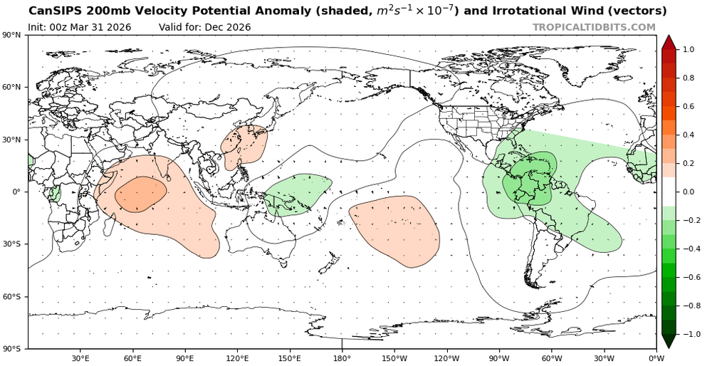
1 minute ago, mitchnick said:
New Cansips out on TropicalTidbits. Similar to last month with lots of blocking. Drier for the east coast than typical for a Niño, but it's a long range forecast.
It did well last year. I was skeptical it would end up that cold. Interesting to see how it does this year.
-
1
-
-
13 hours ago, Baroclinic Zone said:
Booty today. Nice taunt senior citizen. Mid/upper 60s.
Back in the market?
-
1
-
-
2 hours ago, CoastalWx said:
Torch is back baby. Nice warm morning.
By the turn of the decade your metamorphous to torchtiger will be complete.
-
1
-
 1
1
-
-
25 minutes ago, dendrite said:
Still snow piles here

Last of my neighbor's snow-blow pile will go today. I melted out Sunday.
-
13 minutes ago, CoastalWx said:
Man I would ship my family into space to be back at this time 29 years ago.
@MasswxLoves to hear it!
-
2
-
-
12 minutes ago, Damage In Tolland said:
Pushing near 70 with dews
Stay dewy
-
13 minutes ago, weatherwiz said:
Anyone have any stats on how well those extended range snowfall maps verified from like 10+ days ago?
News to me....I checked out after my last blog on like March 9th. I'll do a March wrap up tomorrow and then seasonal wrap up in May...then we're onto 2026-2027.
-
1
-
-
14 minutes ago, Damage In Tolland said:
What a furnace today . Love it
Yea, I figured it would be COC for CT...up here was a lost cause from the get-go.
-
46.4
-
4 hours ago, PhiEaglesfan712 said:
A moderate el nino would be nice for a change. We haven't had a true one since 2002-03. Closest we had was 2006-07 (but that stalled at 0.9 on the ONI and RONI) and 2009-10 (but that went over 1.5).
Moderate el ninos seem to be the sweet spot for good winters in the Eastern US. The only one that didn't really pan out was 1994-95, but that was due to a -PDO, and even then, we got one good month of winter weather (February).
I would def. prefer moderate where you are in the mid atl, but up here, I'd prefer weak.
-
1 hour ago, GaWx said:
Are you talking RONI peak?
Which PDO are you referring to, the monthly NOAA or the WCS graphed dailies, which average ~1 higher?
RONI, since ONI is obsolete.
I use this for PDO:
-
1
-
-
I forecasted 2015 to pull that off, Chuck, and it was a failure aside from getting the blizzard right....but I hope we do it one day. I know we've come close.
-
5 minutes ago, Stormchaserchuck1 said:
In the eastern regions. Even so, our snowstorm composite in the Mid Atlantic is a GOA low which is the much favored El Nino pattern, even in Strong. That means we are a -NAO away from a great possibly historic Winter, with a super amped STJ. I don't agree with your logic about going with a higher number changes the players positionings.
We've been through that....higher end events are going to leak east. You keep imagining this uber-strong, western biased unicorn...have at it.
Yes, strong events are favorable for rouge blizzards, agreed. I called the 2016 event down to the week on a seasonal level. I am talking about temps and NE overall snowfall...only one that was decent for NE snowfall was 1982, which had somewhat of a -WPO.
-
I do not expect it be like 2023-2024.
-
Just now, Stormchaserchuck1 said:
Let's see.. it will be interesting to see if it goes with El Nino and pulls a 2014-2016, or if it continues to meander near neutral despite strong ENSO forcing like 23-24.
I could see it perhaps hanging near neutral like 2004 or 2009....23-24 remained strongly negative.
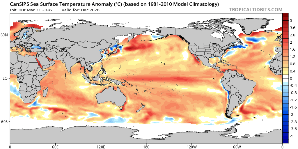
2026-2027 El Nino
in Weather Forecasting and Discussion
Posted
What does it look like in the ENSO region?