calculus1
-
Posts
5,285 -
Joined
-
Last visited
About calculus1

Recent Profile Visitors


-
Forecast few points look fantastic for the next several days, not getting out of the 50s.
-
Oh, that sucks, @BooneWX . So sorry. We wanted the rain, and when it finally came, it came in buckets. I have almost 3 inches in the same time period, but it’s slacked off here. No damage, yet, that I can tell.
-
Same here. 2.4 inches in one hour!
-
That line finally reached us here in Hickory. It’s all yellows and reds. Heavy stuff!
-
It’s remained west of us all day, but some more storms look to be popping on trajectories that may get us again. Regardless, you remain the winner amongst us foothills folk.
-
Same here. It feels different outside compared to the wedge experience we had over the weekend. While not particularly hot, it is decidedly warmer and the humidity is more noticeable. I think pop-up storms are likely this afternoon.
-
1.82 inches so far for me. Not bad, but I thought I would have had a bit more. McDowell County seems to have been the jackpot area in the foothills. @wncsnow. your totals are rocking!
-
I have accumulated 0.59 inch of rainfall since it began yesterday.
-
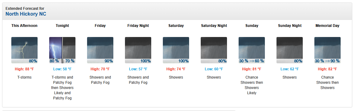
Haven't seen a forecast like this in a long time. Let's hope it materializes...
-
-
This is such a hilarious point-and-click forecast: A 70% chance of rain! [emoji16] Between 2-3 PM. [emoji2955] Less than a tenth of an inch. [emoji95]
-
Yes, the low humidity has been fantastic for the lawn. No brown patch or fungus issues with temps and humidity like this.
-
This has been a huge bust IMBY. Before this last round I had only had 0.31 inch of rainfall storm total. That’s a far cry from the inch-plus in the forecast. Ouch.
-
0.46 for me this morning. Nice!
-
Heavy rain on 321 between Lincolnton and Hickory. Driving back from a day of disc golf with my son in the Charlotte area. It’s been a while since I have seen such heavy rain as this. .