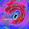
WXeastern Posted November 10, 2012 Share Posted November 10, 2012 Here is the Wxeastern 2012/13 winter outlook..If you have any questions about my reasoning for any aspect just ask and I will gladly answer 2012-13 Winter Outlook Winter weather patterns over the eastern united states depend on several Atmospheric oscillations and Oceanic oscillations. Oceanic oscillation values depend on sea surface temperatures. Atmospheric Oscillation values depend on pressure/height patterns at various levels of the atmosphere. Certain weather patterns usually teleconnect to these oscillations and I have based most aspects of this outlook off of several different oscillations which I will discuss here. *Longterm Oscillations/SST's* -The PDO decadal cycle- The PDO (Pacific Decadal Oscillation) is described as warm or cool surface waters in the Pacific Ocean 20 degrees and north. During a warm or positive phase the west Pacific becomes cool. Eastern parts of the Pacific become warm during a cool or negative phase.. and vice versa. I put most of the weight of this outlook on the current decadal cycle of the PDO. The snowy winters of 09/10 10/11 were products of this relatively new and cold decadal cycle of the PDO.. just like all the snowy winters of the 50's 60's and 70's were part of the last negative/cold decadal cycle of the PDO. It is my belief that the decadal cycle of the PDO is a bigger driver of climate than ENSO is! This value argues strongly in favor of a colder and snowier than normal winter in the southern tier of the nation. Posistive and Negative phases of the PDO -ENSO- ENSO is another Oscillation that is used to get an idea of a future weather pattern. When you here someone mention La Nina or El Nino they are talking about ENSO (El Nino Southern Oscillation). Im expecting a borderline Neutral to weak El nino ENSO episode this winter. This particular value will also argue for a colder and snowier than normal southern tier of the nation. There are other longer range oscillations that IMO are less important to weather patterns over North America..but we wont talk about those here. El Nino and La Nina *Local Shorterm Oscillations* Some of these "local" Oscillations are much harder to predict than say ENSO.. or the PDO because they change much more quickly. Although..sometimes there are signals that correlate these local Oscillations to a particular value. Thats how they become useful in long range forecasting. I label them with the word "Local" because I consider them local in respect to the longwave weather pattern over North America. -EPO- The East Pacific Oscillation or EPO is the western most Oscillation in the set of local Oscillations.The EPO's value depends on values of high and low pressure and/or heights in the Northern Pacific. A positive EPO is a warm signal in the eastern united states during winter.. and a Negative EPO is a cold signal during winter. Recent SST data and wx pattern trends over the northern Pacific are suggestive of a more negative EPO this winter! Positive phase of the EPO -PNA- The PNA (Pacific North American pattern) is a weather pattern with two distinct phases denoted by positive and negative which relates to the atmospheric pattern over the Northern Pacific Ocean and sections of western North America. The PNA is often influnenced directly by the EPO and a majority of the time is a direct opposite value of the EPO. The same atmospheric and oceanic data signals that say the EPO will be mostly negative this winter.. are the same signals that say the PNA will be mostly positive this winter. A positive phase of the PNA is a cold signal here in the eastern US. Positive Phase of the PNA -NAO/AO- Perhaps the most important (During winter) of all these indices that we have discussed.. is the North Atlantic Oscillation and its twin Brother/sister.. the Arctic Oscillation. The reason the NAO is the most important is because its value directly effects our weather pattern here in the eastern US during winter. This is because the NAO is the most local of all the local oscillations that affect our weather during boreal winter. A negative value almost always equals a colder pattern during the winter season. This is due to the high latitude blocking that the negative phase produces. Predicting NAO/AO values outside of two weeks has proven to be extremely difficult.. but again there are correlations that for the most part can usually give one a good idea of the mean winter value. Several different signal's/correlations argue that the NAO/AO will be mostly negative this winter. SST data in the North Atlantic/Summer to winter NAO correlation data/and IMO.. the most important correlation is the October AO to winter AO correlation. All these signals argue that NAO/AO should be mostly on the negative side this winter. However.. if this value for some unexpected reason ends up being mostly positive this winter.. it will trump this and any other cold outlook in the eastern united states. Positive and Negative phases of the NAO --The October AO Correlation-- This October has had an AO value that averages moderately negative! Winter seasons since 1950 with an October AO value of at least -1.00 look like the image below when averaged out tempwise. This correlation STRONGLY argues for a colder than normal winter in the eastern US! Temp departure from normal for winter seasons with an October AO value of at least -1.00 *Winter Analogs* Another method used to forecast in the long range is past weather data of a certain year and season. Most of the analogs are based on the decadal cycle of the PDO...some are based on ENSO and some are based on weather patterns this summer and fall. This coming winter the majority of the analogs are of the colder variety! The analogs that are based on ENSO are ones that take the DJF ONI data only into account. Here is a list of the analogs used in this outlook 1952/53 2009/10 1976/77 2006/07 1987/88 Here is an average of composite temp anomalies for the said winters. -Recent weather Pattern Over North America- If one has been paying attention to the current weather pattern that person could easily see a cold season pattern setting up with the split in the jetstream. Polar/Subtropical. This pattern also favors a colder southern tier of the nation. I can easily see how several powerful Nor'easter type systems (One of them is already currently in the works) are produced from what I expect to be some major phasing of the polar and subtropical jetstream's this year. Having all of this and when I average all these ingredients together I come up with the graphics below which is the last section of my winter outlook. Thanks for reading. Temps Snow Highlights Link to comment Share on other sites More sharing options...
FLO Posted November 10, 2012 Share Posted November 10, 2012 Bring on winter. Link to comment Share on other sites More sharing options...
Lookout Posted November 10, 2012 Share Posted November 10, 2012 Bring on winter. Please don't make posts like this. It adds nothing. We are getting a lot of reports of late about stuff like this and it's getting tiring. A crackdown everywhere is going to be in order if it doesn't stop. Comments like this should be relegated to the banter thread folks...that is the reason we have it. Link to comment Share on other sites More sharing options...
calculus1 Posted November 10, 2012 Share Posted November 10, 2012 -The PDO decadal cycle- The PDO (Pacific Decadal Oscillation) is described as warm or cool surface waters in the Pacific Ocean 20 degrees and north. During a warm or positive phase the west Pacific becomes cool. Eastern parts of the Pacific become warm during a cool or negative phase.. and vice versa. I put most of the weight of this outlook on the current decadal cycle of the PDO. The snowy winters of 09/10 10/11 were products of this relatively new and cold decadal cycle of the PDO.. just like all the snowy winters of the 50's 60's and 70's were part of the last negative/cold decadal cycle of the PDO. It is my belief that the decadal cycle of the PDO is a bigger driver of climate than ENSO is! This value argues strongly in favor of a colder and snowier than normal winter in the southern tier of the nation. I normally see long-term forecasts based largely off the ENSO state. Could you give a little more explanation concerning why you feel the PDO should receive greater weight in these types of forecasts? I'm not saying that you are wrong at all, I'm just curious as to your reasoning behind this position. Thanks. Link to comment Share on other sites More sharing options...
WXeastern Posted November 10, 2012 Author Share Posted November 10, 2012 I normally see long-term forecasts based largely off the ENSO state. Could you give a little more explanation concerning why you feel the PDO should receive greater weight in these types of forecasts? I'm not saying that you are wrong at all, I'm just curious as to your reasoning behind this position. Thanks. This aspect is actually pretty simple to explain. I dont have time right now to pull up all the cold and snow data from the last actual negative decadal cycle of the PDO (1950's - 1970's) but if you're the least bit familar with all the cold and snow across the SE and Mid Atlantic during these decades (especially the 1960's and 1970's) it would be easy for one to see that particular decadal cycle was the root driver of the climate during that timeframe! We have already began to see the effects of this newer cold decadal cycle of the PDO ala the winters of 2009/10 2010/11. In contrast.. the positive decadal cycle of the 80's to roughly the year 2000 was alot less cold and snowy when compared to the 60's and 70's. I can go into more detail later on this evening/tonight when I get back home to my laptop. Link to comment Share on other sites More sharing options...
mackerel_sky Posted November 10, 2012 Share Posted November 10, 2012 Good write up.but if I recall,we had some good cold and snowy winters into the middle 80s,and some alltime record lows for Greenvlle,and Charlotte areas during the time you said the warm cycle began? This aspect is actually pretty simple to explain. I dont have time right now to pull up all the cold and snow data from the last actual negative decadal cycle of the PDO (1950's - 1970's) but if you're the least bit familar with all the cold and snow across the SE and Mid Atlantic during these decades (especially the 1960's and 1970's) it would be easy for one to see that particular decadal cycle was the root driver of the climate during that timeframe! We have already began to see the effects of this newer cold decadal cycle of the PDO ala the winters of 2009/10 2010/11. In contrast.. the positive decadal cycle of the 80's to roughly the year 2000 was alot less cold and snowy when compared to the 60's and 70's. I can go into more detail later on this evening/tonight when I get back home to my laptop. Link to comment Share on other sites More sharing options...
WXeastern Posted November 10, 2012 Author Share Posted November 10, 2012 Good write up.but if I recall,we had some good cold and snowy winters into the middle 80s,and some alltime record lows for Greenvlle,and Charlotte areas during the time you said the warm cycle began? Thanks..during the last warm decadal cycle I know 1985 featured many all time record lows in the month of January in many different states when the polar vortex set up shop at extremely low latitudes compared to normal! But when I said The positive decadal cycle of the 80's to roughly the year 2000 was alot less cold and snowy when compared to the 60's and 70's. Im speaking in general and overall terms of cold and snow!! There will always be extreme cold and warm spells in every decade due to anomalous synoptic patterns no matter which decadal cycle of the PDO one is currently in. Last summer was a perfect example of a very anomalous warm pattern due to strong and intense warm core ridging! Not sure one could trace the anomalous summer ridging of 2012 to any one oscillation. I hope that helped answer your question(s)? Link to comment Share on other sites More sharing options...
GaWx Posted November 11, 2012 Share Posted November 11, 2012 Nice writeup. My comments are as follows: 1) The Nino is as you know is in great danger of not coming back. Although some neutral positive winters have been quite interesting (1935-6 was amazing in Atlanta in terms of cold, rainfall, and wintry precip.), the chances of a really good winter are not as high with neutral positive vs. weak Nino based on history. 2) Based on my research, -PDO REGIMES (such as we're in) have resulted in more than half of the coldest ATL winters. However, the coldest winters usually had a flip to positive for DJF averaged within the -PDO regime. That makes sense since there is a partial correlation between a +PDO and a +PNA/-EPO. We can still get cold with a -PDO in DJF (examples: 1962-3, 1963-4, and 1968-9), but the average winter has clearly been colder with a DJF averaged +PDO (examples: 1935-6, 1939-40 1969-70, 1976-7, 1977-8, and 2009-10). So, if we could get a flip to positive this winter, things would be looking pretty good in terms of cold assuming we get a -NAO. Unfortunately, the recent impressive PDO rise from Sep. 10th to late Oct. has been falling back a bit based on daily SST anom. maps. This will need to reverse before winter to have any chance for a +PDO then. Link to comment Share on other sites More sharing options...
WXeastern Posted November 12, 2012 Author Share Posted November 12, 2012 Thanks Larry and I agree with ur analysis!! Link to comment Share on other sites More sharing options...

Recommended Posts
Archived
This topic is now archived and is closed to further replies.