

RyanDe680
-
Posts
1,419 -
Joined
-
Last visited
Content Type
Profiles
Blogs
Forums
American Weather
Media Demo
Store
Gallery
Posts posted by RyanDe680
-
-
2 minutes ago, Chicago Storm said:
next time know what you're talking about first, before trying to claim an lol victory. see above.
That’s why I shut up. I ain’t bright enough with this stuff to post predictions or what ifs. I’ll leave that to the people who understand this better than I.
now if you want to know how to allocate your 401k, I got you.
-
 2
2
-
 2
2
-
-
Plumes tick up 0z 1/28
-
1
-
-
16 minutes ago, nwohweather said:
This is the problem with most of this thread. It’s been obvious for days that this thing was going to shear apart as it traveled east & with each day the models continued to show a weaker storm once the low pressure center moved into the Ohio Valley. Combine that with mixing issues as the column saturates & questions over the amount of ice aloft always led me to doubt snowfall totals that were shown on the models.
This was always going to be a 4-8” storm in the main swath for IL/IN/MI. I am a little let down at how bad this has trended for the Toledo area, 2-4” is disappointing to say the least. KS/MO/IA look to be in for a heck of a Plains event though

-
1
-
2
-
-
14 minutes ago, Chicago Storm said:
12z NAM

.Wow what a cutoff in IA
-
Plumes for ORD solidly ticked up to 8.5 mean
-
(anxiously awaits part three)

-
Just now, Cary67 said:
I'm sure they will but imo still time to take in more model data that's been sampled and fine tune amts for initial advisories. While still giving public 24-36 hrs notice.
That coupled with the fact that the weather balloons were a bust earlier today
-
Just now, ILSNOW said:
They should go Winter Storm Watch chicago north and west for 6-10 inches.
With a WWA further south
-
28 minutes ago, Baum said:
I ride whatever model shows the most for my back yard. Always have.
^ this
-
1
-
-
But GFS extends more in upper IN, lower MI and NW OH.
-
As time has gone on, MI and IN have really lost out on this as it’s sheared out. IA the clear winner here
-
1
-
 1
1
-
-
39 minutes ago, RCNYILWX said:
So have been taking a closer look at BUFKIT soundings and Cobb output from PSU and starting to think the initial burst late afternoon into evening will have higher ratios than you'd think given the surface temps.
Attached below is the 18z NAM BUFKIT sounding for ORD valid 03z Tuesday. GFS is similar but faster, implying heavy snow as early as 22z Monday.
The white line to the left of the T/Td trace is omega and yellow line on the temp trace is the DGZ. We look for good alignment of strongest lift with the DGZ to feel confident about higher snowfall rates. In the case of this sounding, the omega is strong at greater than -20 ubar/sec and very well aligned with the DGZ. Another factor is the very steep mid upper lapse rates above 550 mb at near or over 8C/km, which is another favorable element for heavy convective snow rates.
As mentioned above, the GFS is faster with this signature seen on NAM sounding and even a hair stronger omega between -25 and -30 ubar/sec.
Given all these favorable factors, I think the Cobb ratio should be given consideration, because the Cobb takes into account favorable lift through DGZ. Output for 18z NAM and GFS is 13-15:1 for several hours after onset of initial burst of snow.
I'm not sure I'd yet go 15:1 ratios, but I think these soundings and Cobb output make a good case to go with around climo (~12:1) and certainly no lower than 10:1 SLR late Monday afternoon through Monday evening.
Edit: And forgot to add, the DGZ itself is pretty deep at about 3kft, which certainly doesn't hurt.

Thanks Rick for this.
-
1
-
-
Some concerns have come up with regard to vaccine effectiveness on the mutations. Unfortunately, there isn't enough evidence to support either outcome.
Initially it was said that the European strain was more contagious but not more deadly, now we are hearing that may not be the case. Again, not enough evidence to support either as it is hard to know how long this has persisted.
-
14 minutes ago, mimillman said:
I don’t think we need to go there please. Horse has been long since dead
6 minutes ago, mimillman said:I find it hard to believe this can go further north with the block honestly.
but is it?
-
where's the guy that said northern counties were screwed? lol
-
1
-
-
33 minutes ago, Hoosier said:
Not sure I understand the wording of your question, and not sure which GHD storm you are referencing, but the GHD 2011 surface low bottomed out under 1000 mb as it appears this one will do. Big difference is that GHD had a 1050+ mb surface high that only gradually weakened, leading to a very impressive pressure gradient. GHD 2015 was also under 1000 mb, but had a weaker surface high.
Yeah I was referring to the original... that's what I was looking for thanks...there's no real gradient here to work with like that storm did and all there is to contend with is NAO block
Be interesting to overlay this storm track with that one when all is said and done.
-
Just now, Baum said:
my professional take is I hope that vibrant pink color gets all the way to my back yard.
Being that you're about 10-15 miles to my west, I second that.
-
1
-
1
-
-
Out of curious, how much deeper was the GHD pressure this far out?
-
Just now, A-L-E-K said:
Unless the wheels fall off, best euro performance here in a while, excellent r2r consistency
unfortunately this is very true. it's been crap for a while.
-
consensus has really trended in the right direction.
Euro and ukie had all the goods early on.
-
1
-
-
Just now, ILSNOW said:
Many thanks.
-
2 minutes ago, wegoweather said:
Plumes trending up to 7.5 at ORD.
I spent 20 minutes looking for that - can you post the link from weather.gov?
-
10 minutes ago, Paulie21 said:
Not sure if this was mentioned but...
"All six weather balloon launch sites along the West Coast and northwest Mexico did not report data this morning, for various reasons. Thus, the major system that is going to affect the Midwest and Great Lakes on Sunday night into Tuesday has limited data for forecasters and models to work with.
Ugh. Use all morning and afternoon models with even more caution."
From Gilbert Sebenste

Should let SpaceX handle that too
-
3
-
-
31 minutes ago, Hoosier said:
Last 3 runs of the NAM ending at 12z Tuesday. Context matters.
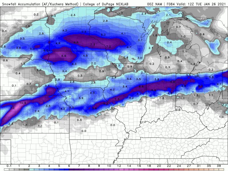
I like when you do this - puts perspective. I dont know how you overlay those images, but keep doing it. I think it helps everyone with perspective and to think twice before commenting... wink wink. thanks for doing this
Coronavirus
in Lakes/Ohio Valley
Posted
First time IL reporting below 4% positivity rate since October 2020 on 90k tests.