

NorthArlington101
-
Posts
10,984 -
Joined
-
Last visited
Content Type
Profiles
Blogs
Forums
American Weather
Media Demo
Store
Gallery
Posts posted by NorthArlington101
-
-
Pretty remarkable how things turned bad within minutes of this thread being opened (right before yesterday’s 12z Euro).
I think it was last year where we deleted/locked the Storm thread and things improved. Wouldn’t hurt.-
 1
1
-
-
Just now, Ji said:
So frustrating
enjoy the sleet bomb

-
1 minute ago, jaydreb said:
GFS even slower.
maybe by an hour? looks practically identical on the head-to-head WxBell maps.


Stunningly similar IMO.
-
10 minutes ago, yoda said:
Plus seems a bit slower... almost looks like no one is getting frozen this run besides the usual far N and W
Careful... TTT doesn't show ice/sleet for the ICON.
Check surface temps. Looks like ice verbatim to me. Shows all ice for CHO actually... heh
-
 2
2
-
-
Nice axis of precip

Might have to drive back up to Arlington
-

EPS not all that enthused about the day 9/10 storm.
-
24 minutes ago, mappy said:
beats lol
you mean beets
")
see, it's those chicken sandwiches. Destroying my brain.
-
EPS are a step backwards on snowfall.
12Z:

06Z:

-
 1
1
-
-
1 minute ago, mappy said:
wait, seriously? you hear Popeye and you think chicken?
seriously! I know the cartoon character but I've never actually watched the show. I would've struggled to get to spinach. Might've said beats instead.
All the Popeye's chicken sandwiches are probably harming my brain cells.
-
I'm not sure if you both watched the clip, but only 54 people in the 100 peep survey said spinach. I'll bet dollars to donuts that at least 40 other morons said chicken, making it a close #2 answer!
I thought it was chicken at first. I’m also young. Think it’s at least partially an age gap.-
1
-
-
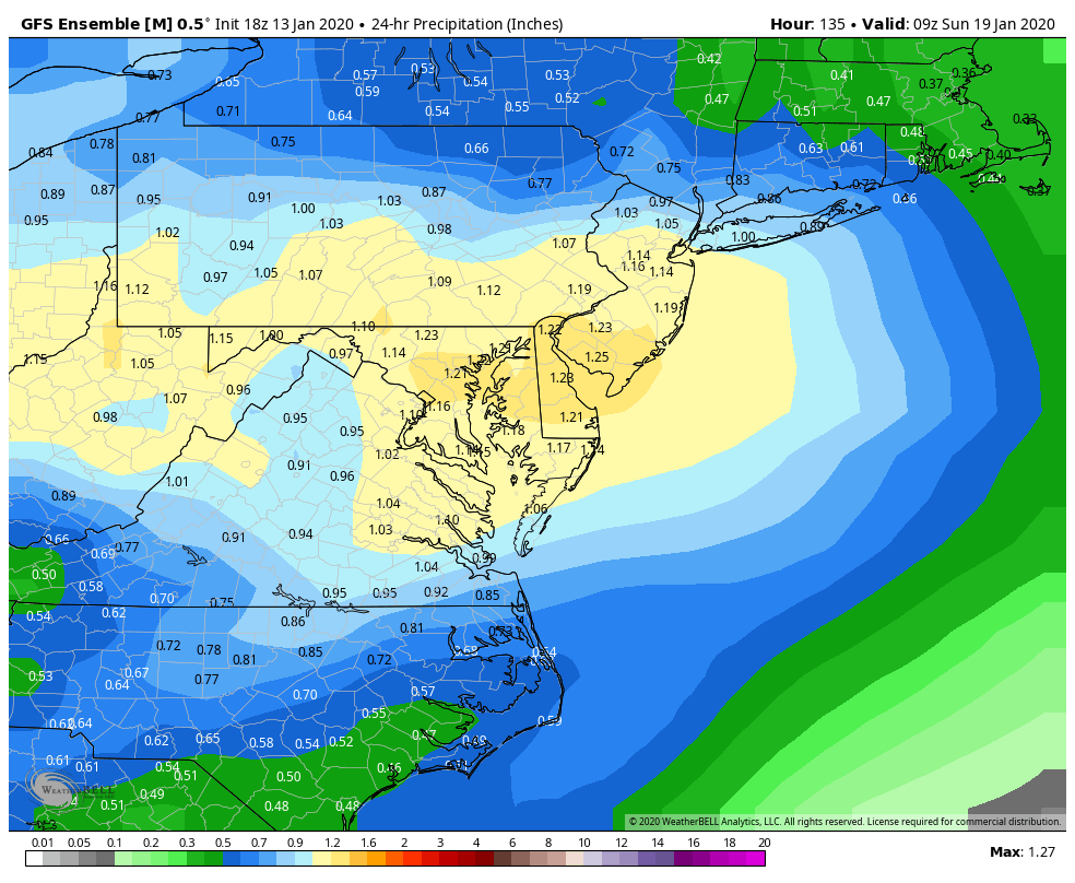
Very light snow in western parts of the subforum at 117/120.
-
18z Gefs is a bit colder then 12z actually
yep. Snowfall mean is unchanged and it still has the look of a mixed precip event -
LOL KC
yikes -
2 minutes ago, WinterWxLuvr said:
I think it’s significant, especially for an ens mean. I’d bet there are some significant storms in that mix
Agreed... there are a handful of big hits. Kinda hit or miss though, with the obvious caveat that it isn't including sleet/ice (which there certainly is some)


fyi, for whatever reason the embedded images are lower quality. noticed this for a couple weeks now. If you click them and open them in a separate window, the quality improves.
-
2
-
-
Just now, WinterWxLuvr said:
I certainly appreciate your maps but for me it would be so helpful to have the 0z map as well for comparison. Thanks
No problem, I'm just cognizant that some people don't appreciate map spam and I try to avoid it. I realize that my definition of "big bump" is different than others though, so both are needed.
0z

-
Big bump in snowfall output on the ens. From what I can tell based on the temps/precip depiction there could also be some ice north/west as well.

-
2
-
-
12z EURO has light snow for DCA at 141.
-
Is that an improvement over 06z?
It’s about the same, honestly. My attempted point was that snow maps aren’t showing the whole picture, GEFS and probably the EPS are showing prolonged mix-y conditions.-
 1
1
-
-
12z GEFS looks intriguing.

-
 1
1
-
-
Anyone’s TV make sounds like there was gonna be a severe thunderstorm warning? Had to check RadarScope real quick.
-
2
-
-
good day to be a Steelers fan
-
1
-
-
Derrick Henry saved my fantasy season and makes me happy tonight

-
I enjoy the chaos

-
Or not

one cheek = two feet
January Banter 2020
in Mid Atlantic
Posted
Now that I'm back in Charlottesville the snow hole has returned to the area.
(I realize this map is unrealistic)