-
Posts
2,479 -
Joined
-
Last visited
Content Type
Profiles
Blogs
Forums
American Weather
Media Demo
Store
Gallery
Posts posted by USCG RS
-
-
?Well, that de-escalated quickly.
But why do I get the feeling that it's a preview of things to come?
Sent from my SM-N960U using Tapatalk
-
This is basically the same physics as thunderstorms, just with bitterly cold Temperatures. The baroclynic gradient setting up is rather intense, yet initial temperatures are cold enough for this to be snow?Yes, but the best chances will be across LI over to southern New England.
Correct?
Sent from my SM-N960U using Tapatalk
-
 1
1
-
-
This is an OEM nightmare scenario tbhThis squall is going to hit at a really bad time since there will be quite a few school buses on the road between now and 5
Sent from my SM-N960U using Tapatalk
-
Evening commute for the tri state area (nyc/nj/LI) one squall, likely becoming a bit larger as it traverses the tri state.Can anyone narrow down a time for this ? Hudson valley by 4 ? Westchester ? Nyc ? How fast will they move and is it 1 line of squalls or several ? A little help thanx
Sent from my SM-N960U using Tapatalk
-
 1
1
-
-
As an emergency manager, I tend to agree with you.There are large expanses of highway without any electronic signage. I think a watch ahead of time would beneficial. It at least would catch people's attention better than the news saying "isolated/scattered snow showers".
Sent from my SM-N960U using Tapatalk
-
-
In all honesty though, Weather tends to be cyclical. The mid 70s was pretty good for nyc in terms of snow, the early 80s not so much. Then we switched to a bit more snow and then the late 90s and early 2000s were horrific and then we switched again.Lets be honest, most snow threats are thread the needle for the coast and immediate NYC metro area. That's what makes this last two decade run pretty much a once in a lifetime stretch outside of a few years with everything coming together perfectly at the right time on so many occasions. We're due a bad luck winter or three, law of averages. Not saying this winter will finish as a ratter but we've been really spoiled the last 15 or so years and should put it all in perspective.
That being said, my crow is delicious. Yes, I'm still eating it from the weekend. I have leftovers for days.
Sent from my SM-N960U using Tapatalk
-
 2
2
-
 1
1
-
-
I would not be surprised at this solution tbh. But a ways to go.big rain storm coastal hugger on 12Z Canadian
Sent from my SM-N960U using Tapatalk
-
And if it is that amped, I would worry about it running inland no?I’m not sure the storm will be as amped as the Op Euro shows. It’s rare to see a storm dig into the Gulf like that. That was almost a 1993 redux which just doesn’t happen often
Sent from my SM-N960U using Tapatalk
-
Damn. She's actually kicking East towards the delmarva/VA region.


Sent from my SM-N960U using Tapatalk
-
Yeah. I just believed that the cold air would be strong enough to lead a non phasing storm to want to follow the temp gradient across the Cumberland gap towards the delmarva. As I noted on another board, in the loop I posted, you can see the attempt to bend toward the VA area and then close up and shoot NE.It was pretty obvious for a few days now down here. The fact Liberty is already mixing just goes to show the immense warming aloft despite the low level cold which far NW has been impressive.
That being said, the warmth is most definitely impressive. I will go over this storm and learn from it and hopefully be better prepared for others like it.
Sent from my SM-N960U using Tapatalk
-
 2
2
-
-
Located?UPDATE: Back to the heaviest snow of the night
Sent from my SM-N960U using Tapatalk
-
LP moving into E PA and HP retreating NE. Looks as if my ship has in fact sunk.
I will eat my crow, and lots of it
@Ericjcrash as I said I would: Nice call on rain for nyc and LI.
-
 3
3
-
-
Sorry. Let me clarify as I quickly responded at work. What I meant is that if the LP in VA were to become the primary one, the surge of warm air would become muted. I have not looked at surface analysis and I was going of njwx85 because I trust his analysis. That being said, if the primary remains the primary this will not take place. Apologies, I should have had this caveat beforeDefinitely won't, theres some misinformation going on.
Sent from my SM-N960U using Tapatalk
-
 1
1
-
-
Eh. I guess we all. Know I'm riding this down with my shipForecast is going pretty much as expected. Primary low isn’t dead yet. Some cyclonic rotation is also present in E PA where the greatest pressure drops have been.
Sent from my SM-N960U using Tapatalk
-
 3
3
-
-
Would mean the r/s line should retreat south.Was this expected? Is it a good thing?
Sent from my SM-N960U using Tapatalk
-
 2
2
-
-
Also.. Can you provide the picture. I can't seem to get my phone to load it on the website.995mb low is still in E KY, winds indicate that secondary low is forming over E VA. Just started mixing with sleet here.
Sent from my SM-N960U using Tapatalk
-
This makes sense to me tbh..995mb low is still in E KY, winds indicate that secondary low is forming over E VA. Just started mixing with sleet here.
Sent from my SM-N960U using Tapatalk
-
-
You certainly have not let up from saying that this would be colder even for NYC and you deserve credit for that bust or not.... kudos to you. Hope your right!


Sent from my SM-N960U using Tapatalk
-
 3
3
-
-
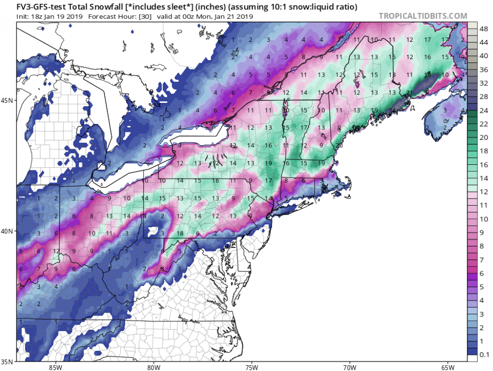
Imo this is a very plausible scenario stillI see 6-10" for NYC and Long Island
Sent from my SM-N960U using Tapatalk
-
Don't be so defensive brother, we know where you stand. If you are correct, I will be happy to publically congratulate you. Likewise you have been steadfast with your forecast, and that's admirable. At this point, we can all agree to disagree and see what happens.Strange forecast. Nothing shows that. Even if CAD hangs on it's still warm aloft and liquid falling.
(for the record, take the tone as friendly. I hate how tone can be misinterpreted via text)
Sent from my SM-N960U using Tapatalk
-
 3
3
-
-
I do not believe we are done moving south yet. Even the NAM tends to underestimate CAD. Likewise, she's going to take the path of least resistance. To me that's the Cumberland gap, delmarva region, not through NJ and just south of LIThe NAM stands alone still; maybe moved 10 miles NW with the transition zone from nada to alotta...

Sent from my SM-N960U using Tapatalk
-
 3
3
-
 1
1
-
-
Nam looks like some rather significant changes at h5


Sent from my SM-N960U using Tapatalk


March 3rd-4th Shellacking threat
in New York City Metro
Posted
All of that being said, I would expect the POTENTIAL for this to be a rather significant (6+) snow event for the tri state.
Sent from my SM-N960U using Tapatalk