

USCG RS
-
Posts
2,799 -
Joined
-
Last visited
Content Type
Profiles
Blogs
Forums
American Weather
Media Demo
Store
Gallery
Posts posted by USCG RS
-
-
Just now, psv88 said:
My kids toys are all over the yard, other than that no problems
I will dispatch a SAR team ASAP
")
-
 1
1
-
 2
2
-
-
About to do some field assessments, anyone here in an area with damage?
-
2
-
-
Just now, psv88 said:
You move to Suffolk and immediately score a Tor lol
Tbh, we have had a couple this year in my neck of the woods. Third (or fourth?) tornado warning this year for me.
-
2
-
-
1 minute ago, Rjay said:
I am Northeast of you by about 12 or so miles. Middle Island.
-
3
-
-
I look to be right in the path. We will see.
-
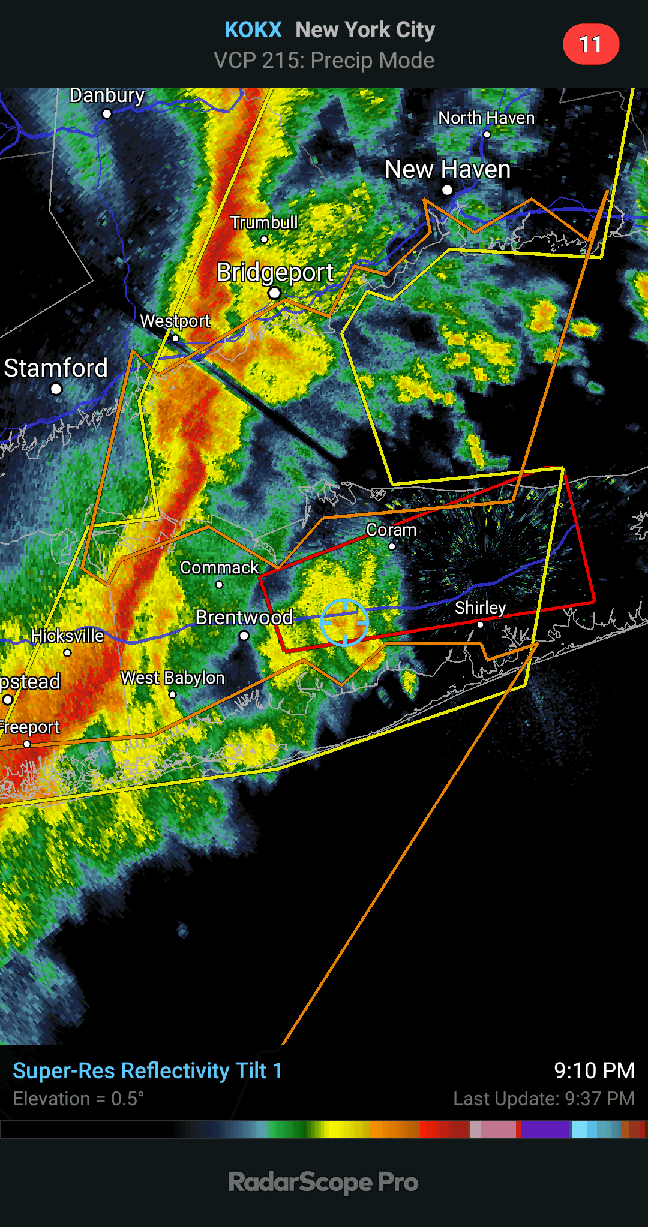
Tornado warning for Suffolk
-
 1
1
-
-
8 hours ago, SnoSki14 said:
We're really feeling the AGW effects now.
It seems as though 2015/2016 was a tipping point with the mega Nino. I think every winter from this point on will be warm/wet or warm/dry.
Snow will be unlikely but not impossible as years like 2016/2017 could still happen.
However this year will likely be another 2011/2012 style winter.
Um?
-
 1
1
-
-
2 minutes ago, SnowGoose69 said:
I’m in Valley Stream. Winds have to be 70-80mph
If you happen to have any damage of note, could you do me a favor and report it here? I work with the red cross in their Emergency Management sector and this field report would be much appreciated.
-
1
-
-
The flow keeps screaming. Until this flow slows, everything is thread the needle. The cold is transient and fleeting as the storms come in. Something needs to anchor in this cold and/or slow down the storms, otherwise the coast (most of our subforum) is really going to struggle.
That withstanding, the Atlantic near Greenland is showing signs of change. What exactly this change is remains to be seen.
Sent from my SM-N960U using Tapatalk-
1
-
-
3 minutes ago, SnowGoose69 said:
12/24/98 is now the top analog for this event. I think someone mentioned it a couple of days ago here
Researching that event, it appears that the front may have been a bit further SE than progged for this event.
-
4 minutes ago, Enigma said:
IMO, it's going to be tough to accumulate given the wet ground and borderline temps.
Unless it thumps, I would tend to agree.
-
1 hour ago, Snow88 said:
Gfs has 4 + for LI
The question is going to be weather the trailing s/w on the front down south can capitalize on the temperature clash over the waters near the NE. If it rides more quickly and devlops more quickly then yes we can develop quickly for NJ, SNE, LI.
If not, then it's a nothing event. Usually post anafront precip is over promised and under delivered. Yet with this particular one - due to the trailing s/w- I am not sold on it being a non event.
-
1 minute ago, psv88 said:
Ha true story my wife just got out of the shower so yea I saw some action haha. Actually true. And yes great snow out here now
Unfortunately this is the most action you have had -and will receive- in the last year.....
-
Just now, weatherpruf said:
You can do both, except meteorology is probably a credit intensive major. There are too many of those these days. That said, i work in mental health and it is an endlessly fascinating field. The best is when you see people come to grips with some serious issues or trauma and then move on to become productive members of society. There are many types of pros working in this field today, lots of opportunity.
I have a great Ted Talk I want to send your way
-
Just now, richm20 said:
The band?

-
1
-
-
Just now, CarLover014 said:
Yes. That is the plan (hopefully). Still have a long way to go though.
If you need help with school (assuming I have a mastery of the knowledge within the area you require assistance) you are welcome to PM me
-
1
-
1
-
-
1 minute ago, CarLover014 said:
Yes it was a secondary interest of mine. Then I got interested in meteorology.
Are you going to obtain a met degree as well?
-
1 minute ago, CarLover014 said:
Mental disorders. Trying to get those BS classes done before the interesting stuff begins.
What are you studying? Psychology?
-
What's it on?I'm having a hard time jumping from this to writing an 8-page paper for an online class. Good thing I have another week to complete it, or it would never get done.
Sent from my SM-N960U using Tapatalk
-
when everyone here is supposedly of an age where acting like an asshole is typically frowned upon outside of ps4 games.
This is America, seems like there is no such thing anymore
Sent from my SM-N960U using Tapatalk
-
1
-
-
Snowing moderately to borderline heavy in Middle Island
Sent from my SM-N960U using Tapatalk -
Yeah.. Models are... Forget it today.I'm not sure any model showed the current radar presentation for 23z. They are all wrong now LOL
Sent from my SM-N960U using Tapatalk
-
Doorman keeping the faithlet one of our pro mets ....talk us thru this surface prog....bet you could write a book about it!


Sent from my SM-N960U using Tapatalk
-
3
-
-
9 minutes ago, RU848789 said:
Thanks, that's nice of you to say - good luck in your final work years too. Didn't realize that MSW was your area and yeah, leaving after 30+ years is a pretty big change (akin to a friendly divorce lol). Fortunately, it was on my terms and they want me to come back part-time (~10 hrs/wk) for 6-12 months to consult at a nice rate, which I'll likely do, as I think it'll be a nice transition and a little extra income won't suck. Lots of bonds, too, as you said: most obviously, I managed groups of 10-25 for the last 20 years and probably 70% of our department was in my group at one time or another, and in addition, there have been the weather notes, the DJ-ing (I've been DJ-ing our annual BBQ and holiday parties for over 20 years and will still do those in retirement at least this year), and the Rutgers football games (our crew of 14 includes 3 guys from work and their wives and with Schiano coming back there's actually hope for the future).
It is quite the accomplishment that your former employer is so intertwined with regards to your forecasts.
Being an Emergency Manager, I first hand know how important accurate meteorological forecasts are, so you have definitely made an impression.
-
1
-


Major Nor'easter snow storm (possible top 20) Noon Wednesday-Noon Thursday Dec 16-17, 2020
in New York City Metro
Posted
I agree