

Boston Bulldog
-
Posts
823 -
Joined
-
Last visited
Content Type
Profiles
Blogs
Forums
American Weather
Media Demo
Store
Gallery
Posts posted by Boston Bulldog
-
-
1 hour ago, Dalfy said:
28F, and moderate snow here in Lebanon, very excited for the 2'' padding. Having lived most of my life south of 40 N it's nice to not have to sweat over the r/s line for once.
Great to have your obs from the middle of the Upper Valley radar hole! Probably the worst area of radar coverage in a New England region of considerable population
-
 2
2
-
-
2 minutes ago, ineedsnow said:
pretty big change on the 12z GFS for the weekend
Very dramatic difference
-
1
-
-
11 minutes ago, CoastalWx said:
He’s crazy lol. He stopped by where I used to work with Mike Ventrice and he was super energetic lol. Obviously a brilliant guy.
Paul operates on a different level than most. Was lucky enough to lead write a couple papers in collaboration with him... let's be honest the concept and research was fully driven by his vision. Come in with a question, and he'd counter back with ideas bouncing off the walls and 5 PhD disseration level questions
-
2
-
-
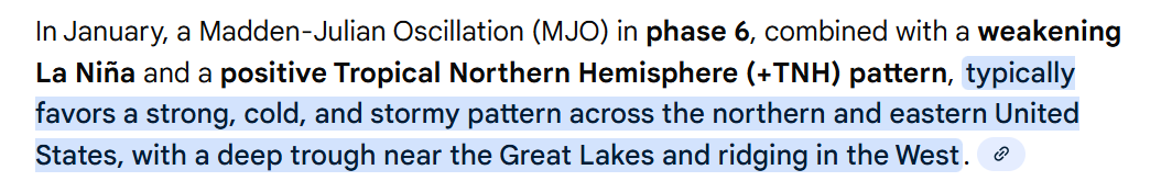
19 minutes ago, TripplePhaser said:
Hmmm...
[my apologies for the format.]

My advisor from graduate school has a fantastic visualizer of the seasonal cycle of the MJO its associated rossby wave patterns. Very easy to see the troughing over the eastern CONUS in Phase 7 out to day 30:
https://www.atmos.albany.edu/facstaff/roundy/waves/rmmcyc/index200reg.html
-
2
-
-
7 minutes ago, dendrite said:
It’s like the gfs gets confused and goes back and forth between strengthening the primary and the secondary. But regardless that’s a chilly solution up here in CAD land. We just can’t seem to ever buy a 40° day here in the heart of winter.
Yeah that failed handoff is really weird and kinda implausible. The atmosphere likes to stray towards efficient energy conservation, the ping ponging of strengthening between the primary and coastal reflection doesn’t really reflect that principle.
I would err towards the primary remaining the more cohesive entity given the modeled dynamics, at least for what the 0Z GFS spits out
-
17 minutes ago, ORH_wxman said:
Icon also turns the 1/10 storm into a SWFE.
Can’t let this cyclone get wound up even a tad or it will cut. However if it gets shredded up into a SWFE, the weekend system is going to set up an intense boundary somewhere. North of that boundary will snow.
A warm outcome is still the most likely path forward IMO given pattern fundamentals, but can’t deny the trends today as we emerge into a new time-scale paradigm for the period. It’s no longer looking like a huge ask to turn the tide here, at least for NNE-
3
-
-
2 hours ago, Boston Bulldog said:
Interesting trend with the warm system late next week. Some OP runs had clean warm sectoring up to the St Lawrence Valley, now the mix line has collapsed substantially south.
Honestly I was initially hoping for this thaw to be potent enough to open up a window of soft snow in the Presidentials alpine next weekend. If it's going to get warm, why not prime up some big mountain terrain? Suddenly dreams of spring skiing under gusty SW winds have shifted back to winter mode with hopes of salvaging surfaces on VT honey holes.
If we continue to trend to a more forceful push of colder air undercutting the ridge, a decent front ender could be possible OR the longitudinal gradient sags south during the storm (if we have a weaker cyclone and more overrunning look). I'm not declaring an early Feb 2022 like event which neutralized a warm longwave pattern in the Greens, but the plausibility of colder solutions is better than it was yesterday. Either way, I hope the pattern goes all in on either a quick and clean warm spell next weekend, or somehow keeps hammering the cold trend. Getting stuck in the middle seems like a very undesireable scenario
0Z GFS continues the trend big time with a SFWE look that halts the warm front’s advance northward. Good to see deterministic guidance showing a cold look is possible.
-
1
-
-
Interesting trend with the warm system late next week. Some OP runs had clean warm sectoring up to the St Lawrence Valley, now the mix line has collapsed substantially south.
Honestly I was initially hoping for this thaw to be potent enough to open up a window of soft snow in the Presidentials alpine next weekend. If it's going to get warm, why not prime up some big mountain terrain? Suddenly dreams of spring skiing under gusty SW winds have shifted back to winter mode with hopes of salvaging surfaces on VT honey holes.
If we continue to trend to a more forceful push of colder air undercutting the ridge, a decent front ender could be possible OR the longitudinal gradient sags south during the storm (if we have a weaker cyclone and more overrunning look). I'm not declaring an early Feb 2022 like event which neutralized a warm longwave pattern in the Greens, but the plausibility of colder solutions is better than it was yesterday. Either way, I hope the pattern goes all in on either a quick and clean warm spell next weekend, or somehow keeps hammering the cold trend. Getting stuck in the middle seems like a very undesireable scenario
-
Data error for the Mansfield stake? Reading is down to 29”
-
Both Feb 2013 and Jan 2015 were modeled to have some sort of stall and loop. While the stalls never materialized, even if they took place the 50” spots would be extremely localized. You’d need to maximize both the initial extreme banding (i.e what was over CT in Feb ‘13) and a CCB type element of the storm, and THEN cash in on the stall via some sort of deformation or decaying mid level banding training over a thin slice of longitude amid what would likely be a shredded occluded mess of a precip shield.
Like Will said, for a storm with more widespread biblical totals you’d need a predecessor phase of the event like the overrunnning he mentioned.
-
2
-
 1
1
-
-
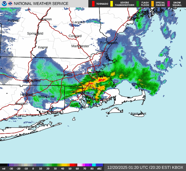
Just drove from Greenwich CT to Port Washington on LI over the past 90 mins or so, and the results are excellent for SNE weenies on the NE edge.
It was absolutely dumping in CT and Westchester. Approaching the Bronx, the distinct sound of rimed flakes appeared, it was clear warm nose is ferocious and ripping north. By the time I reached the Throgs Neck Bridge, it was all sleet. While planning the drive I only expected a hint of sleet by the time I reached my destination. The forecast is going to bust big time down here. This dead duck is going to come in well north
-
3
-
 1
1
-
-
Gotta wonder how much of the NE edge is virga. Extremely skeptical of those accums in NH.
North-south valleys such as the Pioneer Valley may even have some issues too. Extremely cold dry air is going to be advected directly down valley and into the low levels. There are likely to be some maddening discrepancies between radar and reality
-
2
-
1
-
-
NAM looking zonked upstream through 15z tomorrow
-
Raindrops and 36 in Canton, MA
-
13 minutes ago, TauntonBlizzard2013 said:
The reality is, I doubt the models have a 100% handle on the strength of the blocking.
So it’s either going to bump back north, or go further south, which should become clear especially after this current system passes
It is a pretty exotic blocking regime. Over recent seasons we’ve seen general attenuation of modeled features on the map within 48 hours of verification time, and that isn’t just limited to low pressure. The shredder will hold, but recent modeling biases *may* indicate that it is overmodeled
-
37 minutes ago, brooklynwx99 said:
CMC is proof of that... more confluence -> farther south system Friday -> stronger block -> nuke Monday due to farther south ULL
Euro has also shown that when you have less confluence for Friday, the follow up system cuts over the lakes as the trough can’t dig south.
-
1
-
-
Hah from 6z yesterday to 0z tonight the GFS has shifted low pressure for the 26th from James Bay to the Delmarva. Putrid medium range modeling. Expect whiplash to continue a bit longer
-
4
-
-
18z GFS is probably the ceiling for this event in terms of intensity and snowfall totals. There would be some powerful zonally translating mid-level snowbands across CNE and NNE with that dynamic look. Verbatim a high end SWFE that successully jumps to the coast to lock in cold air
For more snow further south, we would need destructive interference to attenuate the shortwave a bit. A scenario like the Euro is still a good storm, but it's not a nuke like this GFS look.
-
3
-
-
Tip was spot on about the shortwave grapeshot earlier this month wreaking havoc on the models. Different synoptic setup here, but still a relentless barrage of weakish vorticity packets passing through the region. I don’t think we’re near the final solutions for post-Christmas.
That said, the late month signal should coalesce into its final form with more lead time than the medium range events did/will.
-
28 minutes ago, CoastalWx said:
Euro is decent for the 26th NoP.
Model whiplash in full effect for the 26th. Euro was plowing this thing across James Bay recently
-
1
-
1
-
-
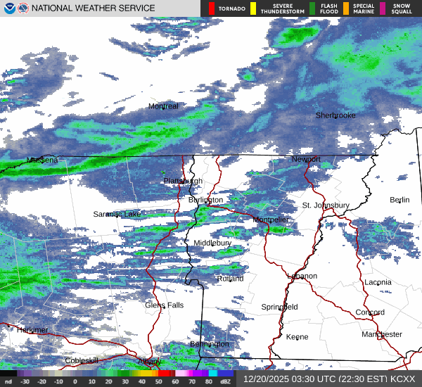
Warned squalls crossing the international border. There's a good amount of zonal motion with this squall, somewhere like Plattburgh or SLK could get an extended period of heavy rates
-
1
-
-
28 minutes ago, Boston Bulldog said:
Big time wishcasting for Boston here, but I’m intrigued by that region of snow back by the Quabbin. Unable to take a look at modeling or dynamics for that feature right now, will that have enough juice to make it east?
Yep, falling apart
-
1
-
-
Big time wishcasting for Boston here, but I’m intrigued by that region of snow back by the Quabbin. Unable to take a look at modeling or dynamics for that feature right now, will that have enough juice to make it east?
-
Northern Greens appear to be flipping back to snow. Snowing furiously on MRG cams since about 1:30. Coverage looks pretty ugly, south of I-89 took a hit
January 2026 regional war/obs/disco thread
in New England
Posted
Snow globe shaken in Boston. Big fluffy flakes floating upwards by the office window