

Boston Bulldog
-
Posts
501 -
Joined
-
Last visited
Content Type
Profiles
Blogs
Forums
American Weather
Media Demo
Store
Gallery
Posts posted by Boston Bulldog
-
-
Impressive lightning just northwest of Albany
-
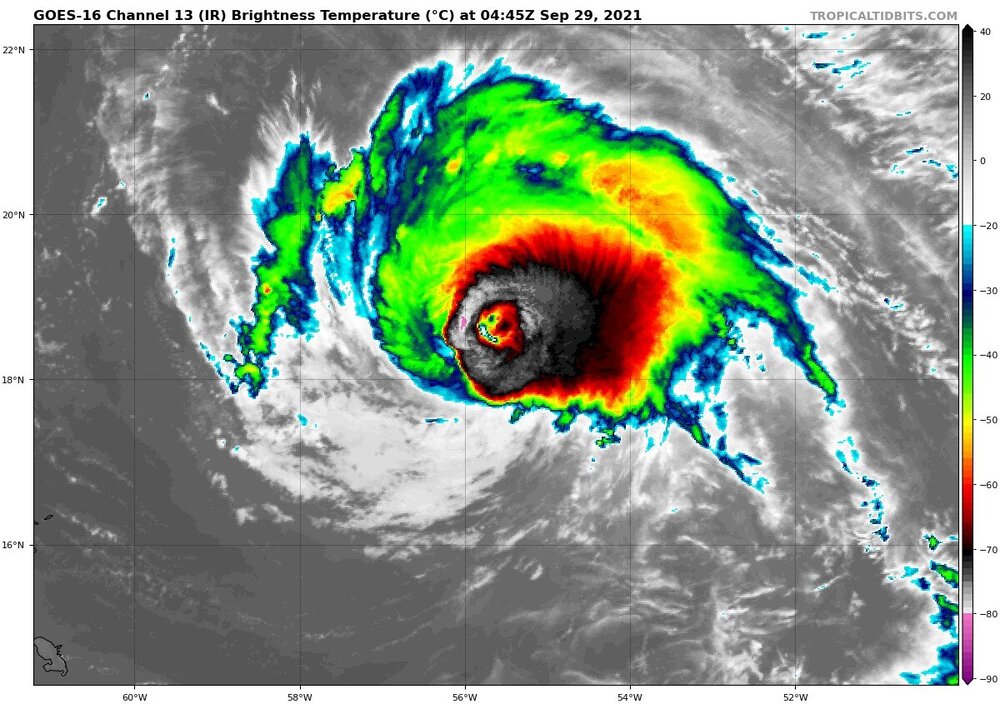
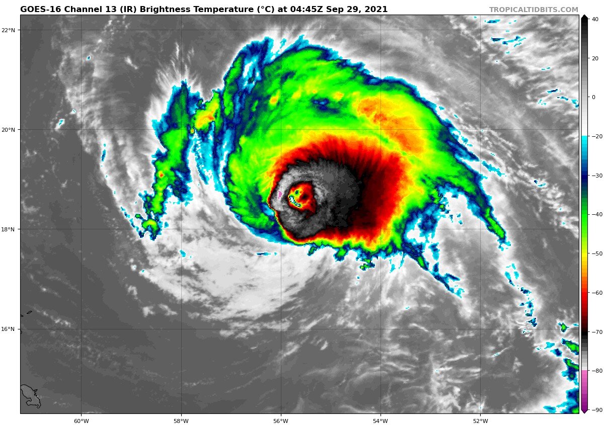
Ring of very intense convection now completely surrounding the eye. This is getting interesting
-
 1
1
-
-
1 hour ago, OceanStWx said:
Gust to 70 mph and a TDS in the ALB area.
Yeah that was legit when it rolled through. Hail seems to have missed to the north, likely over Guilderland
-
65mph and 996 at 11am. NHC now has a Hurricane at Cuba landfall
-
The end of that 3K NAM run is gonna give the fearmongering Facebook and YouTube channels some great clickbate
-
1
-
-
5 minutes ago, PowderBeard said:
Powder skis (115 waist) in the east are best for when 10-14" falls on bare ground, keeps you up above the rocks lol. I like 95-100mm for a daily driver, especially in bumps.
On 8/17/2021 at 12:37 PM, amarshall said:I'm too cheap for a powder ski. My Cham 97s could handle anything from waist deep Alta to skating rink Cannon.
Yep, 96mm Volkl Mantra M5 owner here and I will also vouch for 95-100 as a daily driver. While maybe not as reliable on hardpack/ice at high speed as skis in the 80mm range, the versality is unmatched. Took them from Alta to Mad River and everywhere in between last year
-
To echo what others have said, a phenomenal day out there today. Stowe skied fantastic from about 10am on. I'm trying to upload a pic but keep on running into size issues, oh well
-
2
-
-
Definitely will be a cold start, but if clouds move out like the recent GFS is showing the surface should become forgiving pretty quickly with the current sun angle. Will definitely be a game time decision whether the trek up to The Chin is in play or not
Fingers crossed!
-
1
-
-
Wednesday looking like a potentially top tier corn harvest day in the Greens
-
2 minutes ago, CoastalWx said:
You should have more. Maybe other side of canton.
Yeah I'm close to the Stoughton line. Drove through Ponky earlier today and they definitely had more impressive accumulation
-
4 minutes ago, HimoorWx said:
Only 2.5 - 3 here. Must have been on the wrong side of the coastal front.
Similar numbers here. I think I'm about 2-3 miles to your SW. Rotted at 33 for most of the day and struggled to accumulate outside of the stronger OES pulses
-
Great band blowing up overhead. Dumping fat flakes
-
Still sitting at 32. Anticipating the CF rolls through here soon as Ponky is down to 25 right now
-
It's just puking under this band that's been parking itself over the Blue Hill area. Coastal front enhancement?
-
flurries just transitioned to steady light snow. Nice flake size too
28/21
-
5 minutes ago, PowderBeard said:
Ugh they are still requiring that thing even this year? Many schools in my field started leaving it in the past 2-3 years. This year most schools in my field are not requiring/considering it. I don't get that thing, my quant score was 20 percentile points higher the year I took it than the following year.
Nope, not required anymore. Tried to get ahead of the game by getting it out of the way early, looks like its just a couple hundred bucks down the drain now. Covid was the final push most schools needed to eliminate it.
-
1
-
-
Fitting that my last undergraduate exam before I apply to Atmospheric Science graduate programs is coinciding with this storm. Really hoping I don't lose power as I'm taking it.
Had to take the GRE in Worcester during the peak of the big early December storm last year, sensing a trend here!
-
4
-
-
31.7 with light but steady snow over the last few hours which has actually accumulated much better than during heavier rates seen this morning. Getting some good gusts too, feels very wintery. Knocking on the door of 3.5 inches, hoping some of these bands pivoting in from the NE provide a little boost
Getting down to lake level, probably just over an inch and a half, the accumulating burst during late morning didn't make it down there
-
Big differences between here (1300ft) and lake level (1100ft). Completely white and starting to stack efficiently here, while down in town its still pretty wet, pretty cool ride up the hill
-
34 and moderate snow continues with roughly an inch or so down. Likely won't be able to get into any insane rates, but I think I'll be just east enough to get a good event
-
35 and moderate snow at 1300ft
-
39/34 in Sunapee. Not ecstatic about recent trends, but still very much in the game
-
1 minute ago, ORH_wxman said:
I made a map of it years ago for SNE
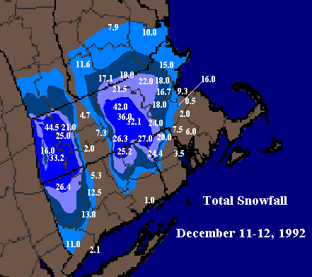
Wow, take a wild guess which one is Blue Hill
-
Definitely more wiggle room out here with that W tick on the GFS
11/26-11/27 Rain Ending as Snow Obs/Disco
in New England
Posted
Over to snow in Sunapee NH (1300ft). 36 and dropping