

bristolri_wx
-
Posts
1,503 -
Joined
-
Last visited
Content Type
Profiles
Blogs
Forums
American Weather
Media Demo
Store
Gallery
Posts posted by bristolri_wx
-
-
Heavy rain here. Lovely weather we are having here in the tropical jungles of Bristol.
-
5 hours ago, Damage In Tolland said:
I don’t see anything showing that big drop they have tomorrow . Tossed
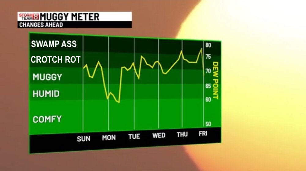
Fixed the graphics for Channel 8...
-
 3
3
-
 1
1
-
 6
6
-
-
5 hours ago, powderfreak said:
Climate shifting, installs where they weren’t before.
I feel like 15 years ago no one had AC up here. Now everyone has it.
Lots of reasons for that though, that aren’t necessarily climate related. Most people moving to forced air systems from water based systems makes it easier for central A/C even if you don’t need it. On some systems it’s now more expensive to get it without it since the central HVAC systems are designed for the entire country.
Window units are also less expensive in relation to inflation now that last are made in China, Thailand, and Vietnam.
I will say the climate related need is that it’s warmer and humid more often than it was a decade ago, regardless of what anyone feels is the cause.
-
6 minutes ago, CoastalWx said:
S coast has been winning this season. Well S of pike in general. Maybe that cell in western mass makes it. Otherwise we water tomorrow.
can’t complain with a good water month aftwr looking like stein. I think I have like 4.7 on month.Not complaining at all - just observing. I’ll take the rain, it keeps things green for the sunny days. We’ve been getting hit with the rain all month even when the most severe part of the storms move just north of me.
-
1 minute ago, Nova737 said:
Seems to have gone south of me. Threaded the needle between us apparently.
They seem to move east from Warwick/Cranston, then jump just slightly north of me into Barrington, and then into Swansea. Happens quite often then just moving straight east into Bristol.
We’re talking 10 miles, but it makes a difference!
-
As usual, the strongest part of the cell skipped north of us. Heavy rain, some wind and lightning. It’s amazing how consistently that occurs, where they move just north of me - about 75-85% of the time.
-
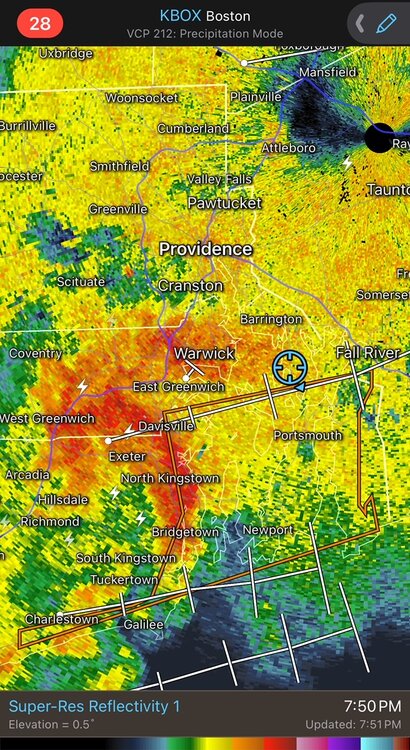
Incoming here… in a severe thunderstorm warning. Lots of thunder and lightning to my west.
-
2
-
-

-
5
-
1
-
5
-
-
1 hour ago, Damage In Tolland said:
Weekend shaping to be a classic HHH with lots of sun in SNE and a PM storm Sunday. One slight mild down early week and then it’s HHH the rest of next week and beyond .
There will be breaks in the beyond time frame just like there have been last couple of weeks. Models haven’t been great at picking up the shortwaves and fronts pushing through until a few days before. It doesn’t look like things truly change until mid July, when heights rise in Canada again.
-
Is that second (SW CT) and third batch (PA) going to to make it here?
-
Power outage here. Torrential rain. Not too much thunder and lightning compared to what was on radar. Worse just to the north of us.
-
14 minutes ago, Ginx snewx said:
3.47 2 day
No stein for you!
-
1
-
-
Hmm this line about to slide into Narragansett Bay looks interesting.
-
Some thunder and lightning here and some downpours but nothing severe. Longest day of the year but it’s quite dark already!
-
15 minutes ago, 40/70 Benchmark said:
Fall of '99, I think...

-
Can't wait for all the dews to arrive! LET'S DEW IT!!!


-
1
-
2
-
4
-
-
Two days of COC before the crotch rot and swamp ass sets in. Enjoy either way!
-
2
-
 1
1
-
-
On 6/10/2024 at 2:47 PM, weathafella said:
Why are people fans of deep cold? I mean -4 isn’t comfortable. We choose the weather we like for reasons other than personal comfort. Most of us would relish a hurricane. Keep in mind you can’t get one hitting you without high dews.
I think you are misunderstanding my context. From an unusual weather curiosity point of view, sure, a heat wave that’s anomalous will tingle the synapses just as much as record cold. And I’m not knocking being interested in weather that’s unusual or record setting.
What I’m not getting is the posts where high dew points are actually being encouraged for getting out and enjoying the outdoors. I would feel the same about trying to go out and ski or snowmobile in -4 temps. Neither are ideal for most. I guess if you really enjoy the beach and beach weather, those hot and humid types of conditions can be enjoyable, especially as you contrast the hot weather away from the coast with the marine influences at the beach. But I can’t see enjoying a family outing in the backyard when it’s 88/70 out.
In the most simplest terms, you can put more clothes on to warm up, but you can only take so much off to cool down before you end up with a misdemeanor charge.
-
1
-
2
-
1
-
3
-
-
3 hours ago, Snowedin said:
When I think of summer, dps in the 50s and comfortable temps don’t come to mind. If I want that boring, stale crap I wait for the darkening, depressing fall months to descend upon me. It may sound a little strange but a big part of me enjoys the dank, sweaty days of the summer season. If I want, I can simply drive 15 minutes to the beach or even just run around like a madman in a sprinkler without an ounce of shame. And when that’s all set and done, I can walk around in shorts and a tee shirt late in the evening and feel the lightness and pure blissfulness of the warm air around me. Because that’s what a season that I wait nearly 9 months for is all about. And you know what, I wouldn’t have it any other way baby.

You can’t do any of those things when it’s 82/55? You gotta be kidding me.
Again I’m not prescribing cold autumn Canadian air here. We have had a number of beautiful COC days as of late here it’s been in the 80’s with lower dew points. Not the Mojave Desert dry air either. Just pleasant. It’s nice to walk outside and not break out into a sweat as soon as you get out of a shady spot.
Maybe you like danky and sweaty, but the people around you sure don’t!
-
1
-
-
Again, I post this tirade every year, but why are people such fans of high dewpoints?
Sunny with highs in the 70’s and 80’s with dew points in the 50’s is what I would consider perfect summer weather, even for this winter fan. It’s good for just about every outdoor activity imagined.
Yet I don’t get the rooting for 85/72? Who wants to be sweaty and uncomfortable? Do you enjoy the crotch rots and the swamp ass? Are you a nudist that doesn’t want to catch a chill at the twigs and berries solstice festival?
I understand enjoyment of almost all kinds of weather except for the ones that like high temps and dew points. They must have stock in deodorant companies and air conditioner manufacturers.
That is all.

-
4
-
1
-
5
-
2
-
 2
2
-
-
Not seeing much heat the next 30 days. Wish we had this pattern in 6 months ago! Cool and wet for at least the next 3 weeks by the looks of it...
-
1
-
 1
1
-
-
CSU Forecast
https://tropical.colostate.edu/Forecast/2024-04-pressrelease.pdf
QuoteColorado State University hurricane researchers are predicting an extremely active Atlantic
hurricane season in their initial 2024 forecast. The team cites record warm tropical and eastern
subtropical Atlantic sea surface temperatures as a primary factor for their prediction of 11
hurricanes this year.
When waters in the eastern and central tropical and subtropical Atlantic are much warmer than
normal in the spring, it tends to force a weaker subtropical high and associated weaker winds
blowing across the tropical Atlantic. These conditions will likely lead to a continuation of well
above-average water temperatures in the tropical Atlantic for the peak of the 2024 Atlantic
hurricane season. A very warm Atlantic favors an above-average season, since a hurricane’s fuel
source is warm ocean water. In addition, a warm Atlantic leads to lower atmospheric pressure
and a more unstable atmosphere. Both conditions favor hurricanes.-
1
-
-
Since it's quiet in here...
https://www.noaa.gov/news-release/noaa-predicts-above-normal-2024-atlantic-hurricane-season
QuoteNOAA National Weather Service forecasters at the Climate Prediction Center predict above-normal hurricane activity in the Atlantic basin this year. NOAA’s outlook for the 2024 Atlantic hurricane season, which spans from June 1 to November 30, predicts an 85% chance of an above-normal season, a 10% chance of a near-normal season and a 5% chance of a below-normal season.
NOAA is forecasting a range of 17 to 25 total named storms (winds of 39 mph or higher). Of those, 8 to 13 are forecast to become hurricanes (winds of 74 mph or higher), including 4 to 7 major hurricanes (category 3, 4 or 5; with winds of 111 mph or higher). Forecasters have a 70% confidence in these ranges.
The upcoming Atlantic hurricane season is expected to have above-normal activity due to a confluence of factors, including near-record warm ocean temperatures in the Atlantic Ocean, development of La Nina conditions in the Pacific, reduced Atlantic trade winds and less wind shear, all of which tend to favor tropical storm formation. -
-
2
-
4
-


July 2024 Observations and Discussion
in New England
Posted
Well looks like my afternoon is going to be wet…