Ellinwood
-
Posts
6,192 -
Joined
-
Last visited
Content Type
Profiles
Blogs
Forums
American Weather
Media Demo
Store
Gallery
Everything posted by Ellinwood
-

Mid-Atlantic Snow forecast For February 13 (Only/Final)
Ellinwood commented on Ellinwood's blog entry in Ellinwood's Weather Blog
Morning update: I would cut back on the totals in MD, northern VA and central PA for now... not liking the trends that I'm seeing. -
Mid-Atlantic Snow forecast For February 13 (Only/Final)
Ellinwood posted a blog entry in Ellinwood's Weather Blog
Boundary temperatures and snowfall rates will be the two main things to watch tomorrow as a nice looking vort. max passes over the region. Precipitation will start off as rain for most/all of the region tomorrow, with the back end of the system changing over to a heavy, wet snow. The strong vort. max will help dynamically cool the air as decent rates form up along the back part of the storm, but with the boundary layer temperatures remaining at or above freezing, it will be hard to get a lot of that snow to stick. Then there is the disagreement between the models. The Euro continues to run drier and further south compared to a host of other models, which is somewhat concerning considering it has never really been on board with the snow totals that I have forecast. Given the non-consensus of the models along with the temperature issues, risks to the forecast are more to the down side throughout the region, though some of the models do still show some upward potential with this storm. All in all, it will just be something that needs to be nowcasted as the bands of snow develop and try to overcome above freezing surface temperatures. -
Mid-Atlantic Snow forecast For February 7-8 (Final)
Ellinwood commented on Ellinwood's blog entry in Ellinwood's Weather Blog
Bust in VA :( Euro track (initially) win. -
Mid-Atlantic Snow forecast For February 7-8 (Final)
Ellinwood posted a blog entry in Ellinwood's Weather Blog
Much more aggressive with the totals this time around, but there is still more upside risk than downside to the forecast. I went with a rough 50/50 blend of the GFS and Euro, with some personal touches here and there. NAM's still out to lunch with it's QPF and snow totals, so I didn't even bother with it. There's going to be some winners and losers in the low-end/mix areas as the details work themselves out. The bulk of the snow across northern MD, southern PA and southern NJ will be during the back part of the storm. The front-end could start off as snow/mix/rain in these same areas and could/should flip to rain at some point before transitioning to snow to end the storm. -
Mid-Atlantic Snow forecast For February 7-8 (Initial)
Ellinwood posted a blog entry in Ellinwood's Weather Blog
Just going to start off by saying that forecast confidence is lower than normal. Miller B type storm will form up late tomorrow into Friday and will initially cause mixing/temp issues across the more southern areas. As the coastal intensifies, banding on the back edge of the system could bring locally higher totals from central PA to NJ, NY and maybe even down into northeast MD and northern DE. There's plenty of risk in either direction, especially across central PA into NJ and NYC/LI. I didn't try too hard to figure out contouring based on strict temperature and boundary layer issue areas since there is not enough certainty to really go into that much detail yet. That's a job that is best saved for tomorrow's update. -
Mid-Atlantic Snow forecast For January 25 (Final)
Ellinwood commented on Ellinwood's blog entry in Ellinwood's Weather Blog
I will when the snow goes away and the boomers come back. -
Mid-Atlantic Snow forecast For January 25 (Final)
Ellinwood posted a blog entry in Ellinwood's Weather Blog
Somewhat higher confidence in the QPF totals brought about an expansion of the 2-4" area. The GFS/NAM continue to suggest a snow hole in the northern VA and DC region, which remains a slight risk to the low side. Overall, I think risks are more to the high side, with localized 2-4" totals possible within the 1-2" contour. Likewise, the 2-4" contour could see localized totals of 4-8" (which is more so for the Appalachians than anywhere else). -
Mid-Atlantic Snow forecast For January 25 (Initial)
Ellinwood posted a blog entry in Ellinwood's Weather Blog
Certainly a new breed of winter storm for this winter as we now have plenty of cold air in place, but moisture will be lacking in most areas. The good news is most of the Mid-Atlantic will see high snow ratios around 15-20:1, giving the event more bang for the buck. Risks are more to the low side at the moment, with the current forecast leaning more towards the wetter European solutions. The NAM and GFS have been fairly insistent on a DC snow hole where accumulations are less than an inch. While entirely possible, I still think there's enough QPF for most to get around an inch. Some of those east of the mountains in PA and NJ have a shot at 2-3" if the higher-end QPF verifies. Confidence is lower than normal with this storm due to the QPF issues and because the energy that will create this system is still somewhat offshore in the Pacific Northwest, so it is not getting sampled as well as it would if it was onshore. -
Mid-Atlantic Snow forecast For January 17 (Final)
Ellinwood posted a blog entry in Ellinwood's Weather Blog
A quick update before I head into work... shifted the forecast further south overall and tightened up the contouring in areas that have slightly higher confidence than the initial forecast. This results in a virtual no-show north of DC aside from some flakes in the air to a dusting. Southern VA into northern NC will get rocked as the vort. max pushes through. There is a risk of this shifting even further south according to some of the hi-res models. -
Mid-Atlantic Snow forecast For January 17 (Initial)
Ellinwood posted a blog entry in Ellinwood's Weather Blog
Here comes the first notable snow event for the southern Mid-Atlantic this winter! A powerful upper-level vort. max will push through the region tomorrow, bringing strong dynamics with it that will help create a period of moderate to heavy snowfall. The snow will start in the morning hours in the higher elevations and will work east through the afternoon and evening. The I-95 corridor will probably start off as rain in the morning. Some sleet could accompany the transition in the late morning and early afternoon, with the changeover to snow occurring around mid-afternoon on I-95 between DC and Richmond. This could lead to large traffic headaches during the afternoon rush hour. Just in case some people might be thinking it, the current forecast is not favorable for thundersnow/thundersleet. -
Mid-Atlantic Snow forecast For January 15-16 (Only/Final)
Ellinwood posted a blog entry in Ellinwood's Weather Blog
Very tough call on the southern edges of the contours as sleet and freezing rain make an appearance as far south as northern MD (not including the mountains). Some locally higher totals of 4-8" are possible, and I put a 4-8" contour area in the spot where I think that is most likely to occur. Ratios should be above 10:1 at least at the start of the snowfall across northern PA before the warmer mid-level air tries to nose in. -
Mid-Atlantic Snow forecast For December 28-29 (Final)
Ellinwood posted a blog entry in Ellinwood's Weather Blog
I did end up bringing the contours further south from DC eastward. Not really anything to add to yesterday's discussion. Good luck with the snow, everyone. I'm leaving to go up north now where there's 18 inches of snow on the ground. -
Mid-Atlantic Snow forecast For December 28-29 (Initial)
Ellinwood commented on Ellinwood's blog entry in Ellinwood's Weather Blog
Yeah... probably gonna have to pull the contours further south around Philly/NJ. -
Mid-Atlantic Snow forecast For December 28-29 (Initial)
Ellinwood commented on Ellinwood's blog entry in Ellinwood's Weather Blog
[quote name='gisman' timestamp='1356642260'] Might want to change the title on this post to the correct dates; predicting things before they happen rather than after gives you more credit. [/quote] Ha! Thanks for catching that... was copy/pasting an old title and didn't update the dates. -
Mid-Atlantic Snow forecast For December 28-29 (Initial)
Ellinwood posted a blog entry in Ellinwood's Weather Blog
Another quick-turnaround forecast as the next system looks to bring widespread 1-4" totals to the Mid-Atlantic, with higher totals in the central Appalachians. Marginal boundary layer temperatures and initial surface winds out of the southeast makes finding that 1" boundary a challenge yet again. Luckily, the upper-level temperatures are cooperating more this time around, so if your surface temperature is at or below freezing you'll almost certainly be getting some accumulation. Mixing areas will mostly be rain/snow, but some sleet is still possible. I'll be traveling tomorrow, so if/when I update it will be in the evening. -
Mid-Atlantic Snow forecast For December 26-27 (Only/Final)
Ellinwood commented on Ellinwood's blog entry in Ellinwood's Weather Blog
[quote name='anthonyweather' timestamp='1356456487'] 4-8" in eastern pa, you also agree that it will be more frozen than not? [/quote] Hard to tell... it'll be a good front-end thump for sure but I don't know how much QPF could come in as rain later on. -
Mid-Atlantic Snow forecast For December 26-27 (Only/Final)
Ellinwood posted a blog entry in Ellinwood's Weather Blog
Forecast confidence is low as most of the snow falls at the front end of the system before many areas switch over to mixed precipitation and/or rain. Very small changes in temperature at various levels of the atmosphere could lead to significantly different snowfall totals, especially east of the mountains. The northwestern parts of the forecast region could/should stay all snow throughout the event, which roughly matches up with the 8-12+ inch area along and west of the mountains. There will be some lingering snow in the central Appalachians at the end of the event as cold, northwesterly flow takes over. -
Mid-Atlantic Snow forecast For December 21-23 (Final)
Ellinwood posted a blog entry in Ellinwood's Weather Blog
No major changes to the forecast, though I did decide to go a bit more aggressive with the totals in some areas. The most notable changes were in northern PA and southwestern NY, with an 8-12" contour added as lake-effect off of Lake Erie helps drive up totals. The back edge of the main area of precipitation is expected to change over to snow, but how much of that actually accumulates ahead of the later snow is uncertain. Localized totals of >12" are possible within the 8-12" contours. -
Mid-Atlantic Snow forecast For December 21-23 (Initial)
Ellinwood commented on Ellinwood's blog entry in Ellinwood's Weather Blog
This is where I made the base map: [url="http://nationalatlas.gov/mapmaker"]http://nationalatlas.gov/mapmaker[/url] Best thing to do is grab the map in parts and make them separate layers in Photoshop, then draw in the contours below the lines and labels. -
Mid-Atlantic Snow forecast For December 21-23 (Initial)
Ellinwood posted a blog entry in Ellinwood's Weather Blog
Since my forecast maps cover parts or all of several different sub-forums in the eastern US, I've decided to just post my snowfall forecasts on this blog to get more exposure without having to spam all of the different sub-forums with my forecast. For those of you who don't know, my main focus with snow forecasting is centered around the Mid-Atlantic. The geographical location does not regularly change from storm to storm, and neither do my snowfall contours. You can interpolate snowfall totals within the contours (for example, the outer edge of the 2-4" contour is for 2", and in most cases the center of the 2-4" contour is closer to 3-4"). I usually try to issue an initial map and one updated (final) map, though sometimes I like to throw in an a second update. Other times, I might only issue one forecast near the start of the event. No updates are issued once the snow starts to accumulate within the forecast region (except in rare cases when the accumulation starts just before I get home from work). ----- Most if not all of the snow with this disturbance will accumulate well behind the cold front, with lake-effect snow bringing some respectable totals to western PA and WV. Most of the snow will fall Friday morning through Saturday afternoon. Low-level temperatures will limit accumulations across central and eastern PA. South and east of the 1" line could see snow in the air Friday, with little to no accumulation expected. -
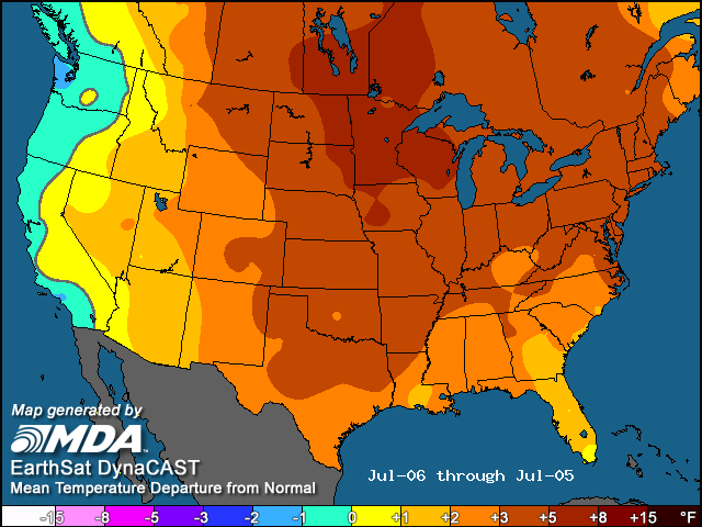
Temperature anomalies July 6, 2011 through July 5, 2012: That's just nuts... not just for our region, but for North America.
-
April 2012: Extreme boredom.
-
I do not.
-
Reconsider majoring in meteorology!
Ellinwood replied to stormguy80's topic in Weather Forecasting and Discussion
No prob. I don't know why anyone would waste their time and money getting a met. degree if they didn't plan on getting a job within the field. I think vortmax112 nailed it. -
Reconsider majoring in meteorology!
Ellinwood replied to stormguy80's topic in Weather Forecasting and Discussion
It has been brought up... more than once... including in this thread.