

Wxoutlooksblog
-
Posts
894 -
Joined
-
Last visited
Content Type
Profiles
Blogs
Forums
American Weather
Media Demo
Store
Gallery
Posts posted by Wxoutlooksblog
-
-
14 minutes ago, NEG NAO said:
explain why please ?
Look at the maps. The LP is way too tucked into the NJ coast.
WX/PT

-
 1
1
-
-
3 minutes ago, NEG NAO said:
then why does CMC show this ?

It looks wrong.
WX/PT
-
 1
1
-
-
3 minutes ago, Allsnow said:
No
Boston will even probably go over to rain.
WX/PT
-
3
-
 1
1
-
-
GFS and CMC are each all rain for coastal areas and the big cities of the northeast. Just not enough or cold enough air.
WX/PT
-
2
-
1
-
-
Another thing as of now worth noting. There is not much of a reinforcing colder air mass coming in on the backside of the storm as it pulls away. This is important because as the lifting and vertical velocity dynamics pass their peak whatever snow there is falling will probably mix or change back over. Instead of an incoming HP we have the upper low which could bring a short period of rain or a mix early Sunday night. The incoming cold air is behind that upper low. But that cold air will most likely be wasted as the next storm system heads for the Lakes.
WX/PT
-
2
-
-
2 minutes ago, Wxoutlooksblog said:
I would be extremely surprised if the NAM correctly called this event Wednesday evening. I'd be shocked really.
WX/PT
I'd be surprised if the NAM got it right Friday evening. Saturday morning it might be within range for the NAM, maybe.
WX/PT
-
4
-
1
-
 2
2
-
-
7 minutes ago, Albedoman said:
lets wait for the NAM run on Wed evening. The potential for accumulating snow is there for sure but WSW criteria will be hard to achieve even in Allentown. We first want to get a better picture for the exact transfer location (sweetspot) nd HP energy in Quebec. The we can talk how much. 48 hours from now will tell us everything on the NAM
I would be extremely surprised if the NAM correctly called this event Wednesday evening. I'd be shocked really.
WX/PT
-
8
-
-
With regards to the micro analysis of the HP to the north. The earlier maps (yesterday and the day before) showed it better locked in place. However please note. This is still marginally cold enough air and its penetration south at all levels is highly questionable. It's going to have to be nearly perfect for this to come together as a primarily snow event for coastal sections and I think we might be on the verge of losing that possibility. On the CMC it's gone. On the GFS it's almost gone.
WX/PT
-
3
-
3
-
-
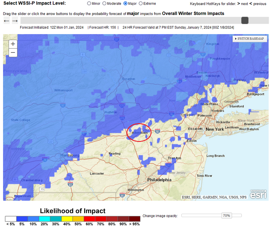
1 hour ago, donsutherland1 said:
Even as there remains considerable uncertainty, it is unlikely that Allentown will see 12"-18" of snow. The potential exists for 6"-12" if things come together.
Select Data:
1/2 0z NBE: 6.2" (the 2z increased the snowfall to 9.0")
1/1 12z EPS Members: 12" or more: 20%; 18" or more: 2%
WPC Probabilistic Winter Storm Severity Index for Major Impact: < 5% (around 20% for a moderate impact)
Oh please! It is not 1996.
-
2 minutes ago, hudsonvalley21 said:
And as Walt Drag just mentioned, there is another system on its heels to contend with.
That system most likely all or almost all rain along the coast and in the big cities as the primary tracks into the Lakes.
WX/PT
-
1
-
-
I'm leaning towards taking the suppression solutions off the table. We are in what would normally be the time-frame where suppressive solutions would dominate. Only the GFS and last night's Euro to an extent have shown significant suppression. I think a major event of some kind is likely here. Exactly what, we wait another few runs to know for sure.
WX/PT
-
6
-
-
36 minutes ago, qg_omega said:
Risk is suppression here not rain
Don't agree. Risk is either suppression or rain. We are in a phase where most of the models will trend south and east. We most likely will be in a trending north/west trend again as the event nears. It all depends on how far these trends go in each phase.
WX/PT
-
1
-
1
-
-
Still got a long ways to go. In the 3-6 day time-frame it may trend again towards less amped then when we get inside of 60 or 72 hours it may reverse and trend a bit towards more amped again. This sometimes happens. We're a long ways from knowing the end result.
WX/PT
-
2
-
1
-
-
Given trends there's a good chance the coastal forms too late and the track of the LP is too close to coastal sections but it could still change.
WX/PT
-
7
-
-
Watching Jan 6th into the 7th. At this point, I have trouble seeing how this works out in in our favor. Definitely a thread the needle situation, if it comes too close to us, we're mostly rain, if it stays too far south we're on the edge of the precip get little if any. The GFS really indicated a nearly perfect track for snow from the Washington D.C. to Baltimore to Philly to NYC and LI. I'd be amazed if it actually worked out that way.
WX/PT
https://www.tropicaltidbits.com/analysis/models/gfs/2023123100/gfs_mslp_pcpn_frzn_us_31.png
-
1
-
1
-
-
No major change in sight.
WX/PT

-
2
-
-
We can wish. The pattern looks infinitely better at the end of the GFS run in the fantasy range. Finally a HP doesn't race eastward from eastern Canada and northern New England and overrunning moisture dumps lots of snow up the east coast. This at this point is nothing really but imaginary but if the fantasy maps were actually to verify we'd probably get at least 4-8" heavy wet snow. But maps on these dates will change a lot between now and then. It's encouraging however to see the model able to come up with this whereas previously we've seen pretty much nothing.
WX/PT
-
Happy Holidays everyone!!
WX/PT
-
11
-
3
-
-
1 hour ago, cleetussnow said:
Theres no real cold on our side of the earth. How that changes or when is unclear to me. I see the 300 hr maps and all but those are theoretical. Nothing really convincing is developing.
I agree. And it's not December 1st or 13th. If what many forecasts for an active and cold winter were going to pan out, it is time to begin to see some evidence of it consistently in the longer range. I do not. Tonight and tomorrow are cold, but over the weekend and into next week, the cold leaves. There is no prolonged cold and none in sight. Yes the New Years Eve holiday weekend might be cold but dry. In order to get snow you have to have the cold and the moisture and/or storm at the same time.
WX/PT
-
5
-
-
Here is the problem as I see it. While we've experienced lots of precipitation due to the almost tropical moisture accompanying storms which have hooked to our west our cold or modified cold outbreaks have been extremely transient and very short-lived. And when it's cold, it's dry. Storms are major super-moist lots of intensity with high winds and flooding and occur about every 7-10 days. Even though precip amounts are way above normal, it is NOT a stormy pattern historically for late December going into January. A stormy pattern over this time is an event every 3 days. When was the last time we got significant precipitation from a storm sliding under us with a cold HP to the north or n/w?? There are some red flags waving for the likelihood of the cold snowy winter forecasts most outlets have come up with. Even today's better looking maps which tend to be over 300 hours away do not show a ridge out west. Yes there's the split flow, but there's never cold HP locked in place when a low moves into the Plains and towards the east. Rather HP slides east of New England the low pressure curves northward and we are doused with heavy rain. I think this pattern of cold/dry alternating with warmer/wet will probably last into mid January at least and maybe longer. Then you look back at late starting winters here. Which ones are memorable? 1978 is the most notable. But I gotta say, there was fierce cold air pouring into the northeastern U.S. that year from November 1977 into December 1977 with several nights dropping well into the teens. We are struggling to get temperatures into the 20s this year. I'm just uncertain that what we'd like to see is going to happen this time.
WX/PT
-
3
-
3
-
-
Would like to point out that a number of winters which featured some great snowstorms started out with some mild to warm weather in early December. 1960 even had several days with temperatures mid-upper 50s prior to the cold and snow which arrived on December 12th. 1982 had a day or two in the lower 70s in early Dec prior to the incredible snowstorm Feb 11, 1983. It is not uncommon to see some mild weather early in Dec prior to a more active and colder winter.
WX/PT
-
6
-
3
-
 1
1
-
-
4 hours ago, gravitylover said:
It's been years since anyone has forecast clippers around here. That's so nice to see.
I agree. Just a few adjustments out west and up north and clippers are capable of tapping bitterly cold air from central and eastern Canada and driving it across the Great Lakes and into the northeast. Right now the ridge is a little too expansive. It needs to retrograde or re-align itself for that to happen.
WX/PT
-
2
-
-
9 hours ago, Jersey Andrew said:
Do you think the pattern will turn colder/snowier as we get closer to Christmas?
There is a chance we will have to wait until later on. Clipper patterns tend to be on the drier side and with a big ridge over the western 2/3 of the country there's little moisture to be had unless you're right by the Gulf of Mexico or in Florida. Anyway in the longterm the pattern could change quickly at almost any time. So we'll see.
WX/PT
-
2
-
-
It looks per the Euro that we're going to get into a clipper type pattern for a significant period of time. This means a milder day or two here and there but also repeated incursions of colder air with the risk of some light snow when the the clipper storm systems move across and there is some cold air still in place. Some of these systems may stay south of the NYC Metro but others could drop over the area from the north and west. As long as it lasts, these systems generally do not bring heavy or even moderate precipitation to the are so precip amounts should be near to perhaps a bit below normal. But we'll experience some cold and who knows, maybe we'll get lucky with a dusting to 2" at some point.
WX/PT
-
3
-
Two Mdt to high impact events NYC subforum; wknd Jan 6-7 Incl OBS, and mid week Jan 9-10 (incl OBS). Total water equiv by 00z/11 general 2", possibly 6" includes snow-ice mainly interior. RVR flood potential increases Jan 10 and beyond. Damaging wind.
in New York City Metro
Posted
Once you lose the colder air you're not getting it back unless there's a new source. The storm could make its own cold air if the peak vertical velocities stay overhead long enough. But often times they don't. We'll have to see. the maps even with my cataracts still show rain. The heavy rain is visible just east of the r/s line in Queens. I'm not sure if the wrap around snow gets in here. The storm is moving quickly rain almost into Boston.
WX/PT