

Sydney Claridge
-
Posts
507 -
Joined
-
Last visited
Content Type
Profiles
Blogs
Forums
American Weather
Media Demo
Store
Gallery
Everything posted by Sydney Claridge
-
Visible satellite suggesting that clearing has started in SW OH just east of Cincinnati. Warm front currently appears to be along the Ohio River at the KY/IN border, east to just south of Cincinnati. I'm starting to wonder about the area of storms forming up near Evansville and whether they might try to evolve into something more significant later in the day. A few of the models (HRRR, RAP, NAM) seem to suggest that some storms will fire up ahead of those later in the day. There's also another area of minor showers/storms east of Indianapolis, though those are currently north of the warm front, and the ones down by Evansville are in the warm sector.
-
Might as well start a thread for this given the 30% Day 4 outlook issued by SPC valid for April 17th: I wonder how major this will be given the large 30% area outlined by SPC so far in advance. The easternmost areas of this sub may still see some activity on the 18th:
-
Tornado debris signature (TDS) southwest of Vance, AL per ABC 33/40 livestream. EDIT: TDS now just west of the Mercedes plant. EDIT 2: TDS has now faded near Brookwood Parkway and George Newell Road. Now watching storm south of Marion in Perry County.
-
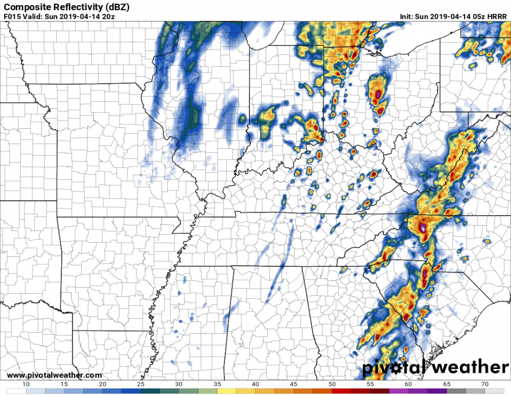
Even though this isn't my subforum, I might as well start a thread for this as there is an enhanced risk in place across mainly southeastern Ohio, though central Ohio (incl. Columbus) is on the edge of the enhanced risk. There are 30% wind / 15% hail / 5% tornado probabilities so far. The 5z HRRR run tries to bring some potent looking supercells through/near the Columbus metro area and into NE OH. If that run verifies I wouldn't be surprised to see higher TOR probabilities. Earlier HRRR runs are a bit more tempered though, though suggestive of discrete storms. 0z NAM and NAM3K seem pretty nasty too, with areas of high (4+) 0-3km EHI in southern and eastern Ohio. GFS-based models are a lot more bearish though. Here's the HRRR run I'm referring to. Definitely a little bullish on the potential: EDIT: and the 6z HRRR run still suggests a supercell (or supercells) forming in the area of the Columbus metro, and moving into NE OH. EDIT 2: the HRRR runs since 5z (including 6z, 7z, and 8z) have been awfully persistent with forecasting discrete storms in central OH. RAP also seems to be keeping things somewhat discrete (at least in central OH) as well. 6z NAM3K is more a threat for SE OH.
-
Yep, seems to be a possible tornadic signature just south of Demopolis.
-
Yes, it looks like that storm (between Rockdale and Lexington) has developed a hook. Would be concerned for the Bryan area if the storm tried to take a right turn, though it looks to pass north of there.
-
Golf-ball sized hail just reported in the area of Six Flags Fiesta Texas and quarter size hail at UTSA. The KSAT live stream suggests more significant hail to the north. EDIT: Baseball-sized hail north of Fiesta Texas (along Washita Way in Legend Hills). At least golf-ball sized hail in the Dominion. Seems like a major hail storm is underway in northern Bexar County.
-

2019 Short/Medium Range Severe Weather Thread
Sydney Claridge replied to snowlover2's topic in Lakes/Ohio Valley
Definitely noticed a few models potentially showing a tornado threat for southeastern Ohio (today's 09z RAP, the last few NAM3K runs), and perhaps into central Ohio (especially in the last few NAM runs) as well, that is if some isolated storms can get going. These models show some high EHI values in these areas (and the 12z NAM3K extends high EHI into western PA as well). GFS is much more bearish though. Would like to see some more model consistency, but over the last day or so the models suggesting a potential tornado threat do seem to have reduced the amount of forecasted VBV in the Upper Ohio Valley region. -
That said, most of the San Antonio metro area is north of the "main city" and the northern suburbs are well-populated. It looks like this storm could be moving towards some of the suburban areas of the SA metro area. I'm starting to get a little concerned for the areas near and along north/northwest Loop 1604 if this thing can hold together, especially if the rotation starts to tighten up.
-
Definitely an interesting solution. I was wondering if this is a bit of an outlier solution though (however the 09z RAP is bringing mid-60s dewpoints into DFW), but the NAM also seems further south than the other models by comparison... 6z GFS (and 6z GFS-FV3) is somewhat between that HRRR run and and the 6z NAM with respect to warm front placement.
-
2019 Short/Medium Range Severe Weather Thread
Sydney Claridge replied to snowlover2's topic in Lakes/Ohio Valley
Tonight's 0z NAM and ECMWF are trying to bring mid-60s dewpoints into Ohio for Sunday, though the NAM shows some VBV issues (I don't have access to ECMWF upper-level winds). SPC has a broad ENH risk from GA/AL all the way up to southern Ohio (just south of KCMH). The NAM and ECMWF bring this warm sector further north than the ENH risk, up to at least Mansfield or so (around the north end of the Slight risk or so), and ECMWF gets 60-degree dewpoints as far north as Cleveland. Would expect to see the ENH moved north (to include Dayton and especially Columbus) if NAM and/or ECMWF verify. SPC says damaging winds are the primary threat, though they predict tornadoes will be possible near and west of the Appalachians. I'm slightly skeptical with the VBV issues (and with the GFS being less aggressive into the OH/KY/WV area), but we'll see what happens. This would be with the same system responsible for tomorrow's severe in east Texas and LA/AR (and that is where the bulk of the tornado threat with this system will likely be). The 6z NAM run is a little less aggressive in the Ohio area I would say, with slightly lower dewpoints and lower temperatures, and less EHI present. -
I'm in DFW and I'm glad to see that the NAM and GFS models are not putting me in the warm sector here. That said, the warm front will likely be fairly close to DFW (especially if the GFS verifies), though the best helicity will be off to the east by the time that happens (the helicity seems to be in place with the NAM though, and today's 18z NAM run seems to be moving the warm front ominously close to if not on top of parts of DFW). If this storm system winds up northwest of where the models are depicting it for some reason, then I might be a bit more concerned where I am at.
-
The GFS-based models (GFS and GFS-FV3) are placing the warm front with the Saturday system just south of DFW on the 0z runs. Those models do seem to have moved the front's location slightly further north with each of the last few runs. The 0z runs puts DFW in the upper-50s for dewpoints with mid-to-upper 60s dewpoints just to the south and SE. It will be interesting to see how far north the warm front can come, as well as what the NAM has to say about it as it comes into range.
-
March 13th-14th Severe Weather
Sydney Claridge replied to HillsdaleMIWeather's topic in Lakes/Ohio Valley
I'm surprised SPC went with a severe thunderstorm watch in OH/SE IN/KY rather than a tornado watch, given all of the helicity in place. -
March 13th-14th Severe Weather
Sydney Claridge replied to HillsdaleMIWeather's topic in Lakes/Ohio Valley
And just like that the tornado warning west of Dayton is cancelled. That said, the supercell about to move into the Cincinnati metro area looks pretty powerful compared to the other storms on the radar. It is severe-warned for 70 mph wind gusts and half-dollar size hail. EDIT: it is now tornado-warned too. EDIT 2: it seems like a tight rotation is trying to move into Florence, KY per WLWT livestream. It seems like it wants to follow the I-71 corridor, so if it can hold together that long then even Columbus might be in its path later on as well. -
March 13th-14th Severe Weather
Sydney Claridge replied to HillsdaleMIWeather's topic in Lakes/Ohio Valley
I'm wondering a bit more about that supercell that is now midway between Louisville and Cincinnati (the one following the Ohio River), near Madison, IN. No tornado warning on it but it looks pretty potent on radar (at least in terms of the colors being displayed). And just as I type this, a tornado warning goes up for another cell just west of Dayton, OH. -
March 13th-14th Severe Weather
Sydney Claridge replied to HillsdaleMIWeather's topic in Lakes/Ohio Valley
I've been thinking the same thing all day as well. RAP is bringing the best EHI from the current storms in KY/IN all the way up to north-central Ohio; HRRR keeps the highest EHI values west of CMH. Not going to rule out tornadoes near CMH though (SPC has a 5%-10% in the area for a reason). This is very much a now-casting situation. -
March 13th-14th Severe Weather
Sydney Claridge replied to HillsdaleMIWeather's topic in Lakes/Ohio Valley
Eagerly anticipating the 1630Z SPC convective outlook. Some changes are bound to be made, especially for central and NE IL, plus NW IN, given the storms in that area. Not to mention that clearing along the Ohio River is bound to introduce some issues down the line for Louisville and Cincinnati as well. -
March 13th-14th Severe Weather
Sydney Claridge replied to HillsdaleMIWeather's topic in Lakes/Ohio Valley
I had been wondering about the storms over central IL as well. There's plenty of sunshine to get things destabilized there, and its fairly close to the low pressure system too. -
March 13th-14th Severe Weather
Sydney Claridge replied to HillsdaleMIWeather's topic in Lakes/Ohio Valley
I find it interesting that multiple runs of the HRRR and RAP want to destabilize an area of Ohio (mainly western and central parts of the state) well ahead of the broken line of storms we are currently seeing around Paducah. If one of those models verifies, EHI values may be fairly high in that area. If SPC does decide to add in a hatched area for significant tornadoes, I'm going to be placing my bets on western and central Ohio (and perhaps eastern Indiana too) given what these models are showing, especially if storms can tap into that energy (though the modeled EHI values seem to drop as the broken line approaches). Basically what these models are showing is a broader area of instability into Ohio compared to the relatively narrow instability axis we are currently seeing. -
March 13th-14th Severe Weather
Sydney Claridge replied to HillsdaleMIWeather's topic in Lakes/Ohio Valley
The current RAP runs (11z) seem the most aggressive at the present moment, especially with respect to western and central OH. Would not be surprised to see tornadoes (perhaps strong tornadoes?) if that RAP solution verifies. Other models (like the NAM3k and HRRR) bring in less instability, so more conservatively I would not expect significant tornadoes either. SPC's new outlook (still ENH, 10% tornado/30% wind as far east as Columbus, OH) says that if stronger instability can develop then they might have to introduce a significant tornado risk. -
March 13th-14th Severe Weather
Sydney Claridge replied to HillsdaleMIWeather's topic in Lakes/Ohio Valley
18z HRRR shows no lack of warmth ahead of the front. There's a lot of SRH shown over the warm sector and mid-60s to lower-70s temperatures with dewpoints modeled in the upper 50s to lower 60s across western and central Ohio. If storm mode can remain discrete (and sufficient cloud breaks occur as previously mentioned) it seems that the potential for tornadoes is there. Looks promising provided that everything comes together just right. That said, the NAM3K is a bit less aggressive with destabilization. I know the HRRR can be a bit overdone at times, though. It is also showing pockets of high temperatures in the lower 80s over western WV, SW PA, and SE OH, though this area is not under the moist axis (temperatures under the moist axis are generally being modeled in the 60s to near 70 at best). The HRW models and the NAM 3k (the other CAM models available on pivotalweather.com) are at least somewhat consistent on a temperature spike into at least the mid-70s occurring over this region, though. -
Severe storms 3-9/12
Sydney Claridge replied to AfewUniversesBelowNormal's topic in Central/Western States
There was a 75 mph wind gust reported at Fort Worth NAS JRB per the storm reports on SPC's website. I'm close to that area and didn't get any sort of strong wind gusts at my location to my understanding. EDIT: updated severe thunderstorm warning for Dallas County mentioning 80 mph wind gusts as a possibility. Hearing reports of power outages in various areas of DFW over Facebook. Expecting to hear reports of storm damage filter in across the DFW area over the next few hours especially once daylight comes along. -
Severe storms 3-9/12
Sydney Claridge replied to AfewUniversesBelowNormal's topic in Central/Western States
Severe thunderstorm warning now up for much of Tarrant County, including Fort Worth. NWS saying hail up to half-dollar size is possible. -
Severe storms 3-9/12
Sydney Claridge replied to AfewUniversesBelowNormal's topic in Central/Western States
Still thinking about those storms east of Abilene. They look to be currently in an area where they would stay elevated, but it seems that per the SPC Mesoanalysis they could be moving into an area with some surface-based instability. I'm wondering if they are about to intensify and become severe, especially if they can become surface-based. These are fast-movers (forward speeds of 60+ mph in places) per the significant weather advisories so we should find out soon. EDIT: and SPC has just put up a new mesoscale discussion saying that a watch is likely from west of DFW into SE OK, SW AR, and NW LA. It suggests that the storms might stay elevated in the western part of the MD area, but may become surface-based later on.


