Sydney Claridge
-
Posts
532 -
Joined
-
Last visited
Content Type
Profiles
Blogs
Forums
American Weather
Media Demo
Store
Gallery
Everything posted by Sydney Claridge
-

2020 Short/Medium Range Severe Thread
Sydney Claridge replied to Hoosier's topic in Lakes/Ohio Valley
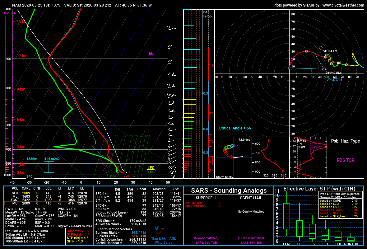
This same 18z NAM run also ramps up tornado parameters along the warm front in eastern Ohio at the same time as well, as per this forecast sounding. The NAM does not initiate precipitation in this area though, so it seems the threat there would be much more conditional if this run verifies. Forecast parameters are lower in the area between E OH and IL. Lapse rates on the 18z NAM run are also pretty high, with Plains-like 7.5-8.5 values from Illinois over into Ohio.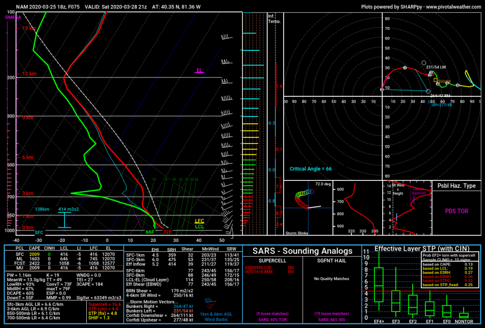
-
I'm surprised that SPC still has a "potential too low" in their Day 4-8 outlook. There seems to be a pretty good chance that there will be severe thunderstorms later this week, particularly in the Texas/Oklahoma region, based on various model runs.
-
I believe the lapse rates were pretty high with this severe weather event. That could have compensated for the lower temperatures and dewpoints somewhat. This also seems to be the first really bad tornado this year. It’s only been a few months since we had a tornado go through north Dallas on October 20th, so it has not been too long since we last had a tornado go through a densely populated urban area. Unfortunately this time around people lost their lives (unlike in Dallas, despite that being one of the costliest US tornadoes monetarily, and that tornado was probably weaker than what moved through Nashville), and the late-night timing could not be worse.
-
If we are going to see above-normal temperatures and precipitation at the beginning of March, perhaps the severe storm season could start to ramp up. GFS and Euro are both depicting a storm system for the Southern Plains for early next week (around March 2nd), with what seems to be sufficient moisture return across Texas into southern Oklahoma. We are still a ways out, so any model data should be taken with a grain of salt, but the modeled pattern caught my eye (with multiple low-pressure systems moving out of the Rockies on the GFS, and a big storm on the Euro). I'm a little concerned about the late-week storm (that should impact the Great Lakes with snow) scouring the Gulf of Mexico of moisture, though water temperatures are above average across much of the GoM.
-
Need to watch that storm NW of San Antonio for hail potential. It’s just behind the front so I would expect it to stay elevated (and SPC agrees), though the surface warm sector is fairly close.
-
Storm initiation looks to have started just east of Wichita Falls. Looks to be on the front itself.
-
Had a dusting of snow up near Texas Motor Speedway earlier today.
-
GFS seems quite the outlier right now, depicting a major snowstorm over the north Texas area (especially just west of DFW) on Wednesday. Most other models (NAM, Euro, etc.) are further north.
-
Maybe an early start to the spring severe season is in order? Not going to comment on summer at this time. GFS gives some threat across the SPC-delineated regions for Friday and Saturday though the Euro runs look more amped (bringing a fairly-humid warm sector as far north as the Ohio Valley next weekend); if those Euro runs verify then a stronger storm system would track from central Texas to the Midwest-Great Lakes region. EDIT: The only cold I see for DFW is way out in GFS fantasy land. I guess we know how that tends to go.
-
I'll guess 1250 total tornadoes, first high risk April 1st.
-
I know we are only in a marginal risk zone, but the storm parameters over the DFW area look somewhat interesting right now. Temperatures in the lower 70s (in places) with upper 60s dew points, in conjunction with some high helicity values (ESRH in the 300-500+ m2/s2 range), could produce some potentially severe storms if we can get storm initiation, though veer-back-veer seems to be an issue based on the change in wind directions between the 700mb and 500mb levels (based on the available SPC mesoanalysis data at the time of this post).
-
The GFS-based models (GFS and GFS-FV3) are placing the warm front with the Saturday system just south of DFW on the 0z runs. Those models do seem to have moved the front's location slightly further north with each of the last few runs. The 0z runs puts DFW in the upper-50s for dewpoints with mid-to-upper 60s dewpoints just to the south and SE. It will be interesting to see how far north the warm front can come, as well as what the NAM has to say about it as it comes into range.
-
Me too. GFS is showing a pattern suggestive of cold waves in the Northern and Central Plains (along with surging cold fronts) but I'm not counting on that to translate into the Southern Plains as I've always noticed a cold bias with the GFS in the longer ranges.
-
And we're down to a Slight Risk now. According to the reports so far the Moderate Risk seems like a bust, aside from the Columbus tornado. (there's not many severe reports in the former MDT zone)
-
Just wanted to pitch in and say that today's 0z NAM3K solution looks a bit ominous for W TN and N MS, with broken cells traversing across a fairly high-EHI environment. 0Z HRRR is even more ominous, showing isolated cells from south-central MS up into central IL (with dewpoints >= 60F even there), with particularly severe-looking cells ahead of the cold front (which itself has broken cells along it) from south-central MS into southernmost KY, though I'm aware that specific model can be somewhat overdone.
-
Central/Western Medium-Long Range Discussion
Sydney Claridge replied to andyhb's topic in Central/Western States
NE Texas is in the Day 6, so they might get involved it seems. Like you said, barring a westward shift, north-central Texas and DFW probably will not be involved. Seems like a potential western Dixie and mid-Mississippi/Lower Ohio valley event based on the SPC outlook thus far. -
Central/Western Medium-Long Range Discussion
Sydney Claridge replied to andyhb's topic in Central/Western States
I was noticing that on the model runs as well. What are the probabilities that north-central and NE TX gets involved here? (though it's probably a bit early to say) Today's 12z and 18z GFS runs are at least hinting at the idea (though somewhat earlier in the day), but that is just two runs of the same model. The potential event is still over a week out so the models will definitely become more refined as it draws closer, and perhaps more questions can be answered then. -
I cannot help but notice that the models are depicting a fairly active pattern over the next few weeks, with multiple systems off the Pacific coast (some fairly strong), and some staying fairly strong as they emerge onto the Plains. If we can get sufficient moisture return (the big "if" in February), perhaps we might be entering a favorable pattern for severe thunderstorms soon if the models verify.
-
And the slight risk is back into the DFW metro as well, and even now extends south of DFW for wind and hail. Highest tornado probabilities (5% within 25 miles) are in the northern section of the metro northwards to the Red River and over towards NE TX, SE OK, and central AR. It's also interesting to see the elevated thunderstorms in NW OK, where there is a severe thunderstorm warning in effect for an area where some of the surface temperatures are hovering near the freezing mark. Now if only that activity was in the warm sector...
-
Agreed. Even just looking at the RAP used on the SPC Mesoanalysis site, that model placed the freezing line about three counties too far west. At least most of DFW seems to be above freezing (though just barely) now, though some places in Tarrant and Denton counties still seem to be at or just below the freezing mark.
-
Interesting note regarding the location of the freezing line. Some of the personal weather stations on Wundermap (accuracy is a concern though) are averaging around 32 in portions of southern Dallas County (and close to it in Irving and NW Dallas County), and even in the areas that based on radar data appear to be just plain rain in SE Tarrant are averaging around 32 as well. Here in west Fort Worth a light coating of ice has formed on my tree branches. It will be interesting to see how far west the freezing line shifts over the next few hours, and part of me wonders if it will not shift as far west as forecasted. Hopefully the freezing line shifts west out of DFW in the next couple of hours as forecasted, before there is an opportunity for ice accumulation to become a major issue.
-
I'm on the west side of Fort Worth and there is currently a light rain with temperatures just below freezing (31F), with most of Tarrant County (aside from the easternmost portions) also at or just below freezing. Paved surfaces seem wet and not icy at the present moment, although there does seem to be a little bit of ice on surfaces that are less likely to retain warmth (like leaves and the metal railing just outside my house). Concern for icing seems to be further west where precipitation has yet to develop (but will), as per SPC mesoscale discussion.
-
Should be interesting to watch, that's for sure. And in fact, this morning's 6z NAM run is showing a potential icing event from the Hill Country up towards DFW, with greater ice accumulations showing up around Llano and Gatesville (with the event ongoing at the end of the run, though it's too early to delineate where winter precipitation may accumulate at this time). But like you mentioned, the GFS and other global models are not picking up on anything.
-
I wonder what everyone is thinking about the severe weather potential tomorrow in Texas? Currently SPC has a slight risk in place for an area roughly bounded by Fort Worth to the NE, Killeen to the SE, and Abilene to the W. Multiple NAM and NAM3K runs are getting some pretty high EHI values into parts of the north-central Texas region, though SPC is calling the NAM overdone. Just waiting for what the 18z HRRR run has to say, though; that said, the 12z HRRR run does keep the surface-based instability south of the DFW Metroplex by about 2 counties or so.
-
Tornado warning now for Collin County, including highly populated areas of McKinney and Plano.