
Torchageddon
-
Posts
1,332 -
Joined
-
Last visited
Content Type
Profiles
Blogs
Forums
American Weather
Media Demo
Store
Gallery
Posts posted by Torchageddon
-
-

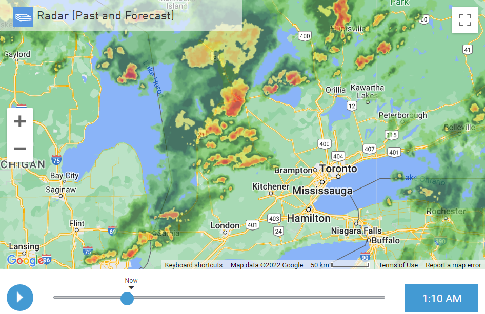
The potent low in Georgian Bay was spinning away all day and bands like a hurricane kept feeding off Huron. The spin was easy to spot on sat and even radar!
-
36 minutes ago, frostfern said:
It's getting to me here too. SAD is already starting. I will be happy when it snows, but this dark dreary drippy s*** is useless.
I haven't felt the onset of SAD yet, but another 1 or 2 days of this I might. I've actually gotten a jolt to the noggin from the change of seasons which temporary gives me more energy, motivation, and ideas even during the first snowfall.
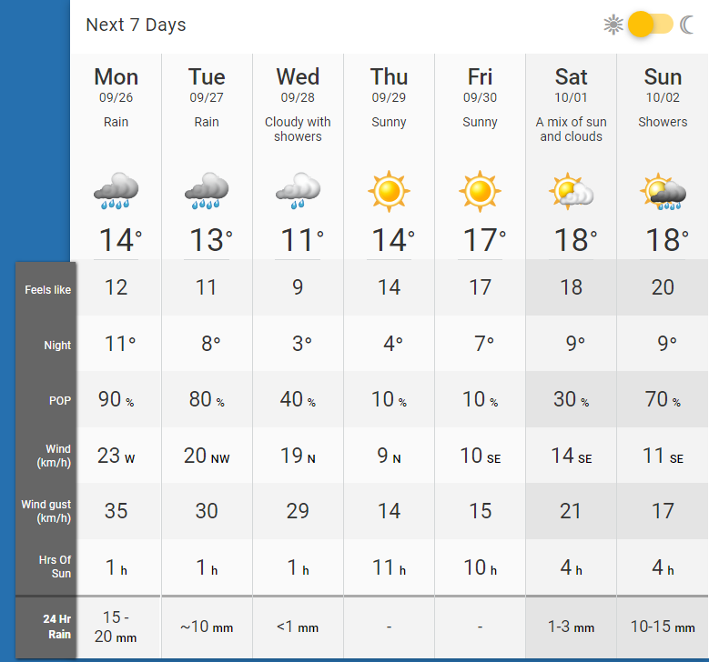
This is perhaps the rainiest non-storm day of the year - at least 28 mm or 1.1 inches so far. I got up to a rate of 3mm/h or .12 in/h . The historic rain event of last Sep a year and a few days ago I recall a rate of 5.5mm at one point like a t-storm downpour. As my hourly showed I'm getting brief heavy rain spells. Meager sunlight and rainbows this morning with the ominous darkness to the north at the beginning of this rain storm.
-
Atrocious wx continues here, this is the earliest I've needed the heat on. Dark, cold and rainy for 3 days already then I see this (normally I don't check this anymore for good reason but something forced me to):
Is this a joke?
 And here I was hoping for a repeat of 2017 during the period. I better stop as its the opposite! As soon as the calendar turned to autumn it was full-on s***.
-
 1
1
-
-
11 hours ago, olafminesaw said:
This explains it pretty well:
That was an awesome graphic set by Papin, never seen it explained like that nor the products shown. I can't figure out what the K is for 340-K potential vorticity in the 2nd graphic, searched but couldn't find answer.
-
 1
1
-
-
Ended up getting no rain and exceeded forecast highs today. The storms were south of me and the sun came out for a few hours this afternoon then more annoying clouds rolled in at 3. I can't remember the last time I was under an advisory/watch/warning.
-
Had a very warm overnight low of 18C/64F for this spot in mid-Sept, overcast with humidity combo to get it. Inside I didn't drop below 25.5C/78F.
-
I've been having some bad wx lately, dark and overcast yesterday with cold temps in the low 60s (much colder than forecast) then a bit warmer today however still dark and overcast ugh. It was suppose to become partly sunny at noon and it didn't happen.
-
1
-
-
I'm up to 107 mm of rain for the month, likely in the top-tier but since my records are incomplete I'm in the dark. The pattern of getting moderate rains and then sunny days spaced ideally maximizes crop growth. I can't recall an August that was this perfect for growing. Morning had a stray isolated shower pass over me then another at noon, followed by partly sunny and very humid. I missed the main MCS that rolled through MI/ON in the evening to the south.
-
16 hours ago, cyclone77 said:
Another nice downpour, up to 0.95 for today, 1.13" since last evening.
Always nice to see this out the front door.
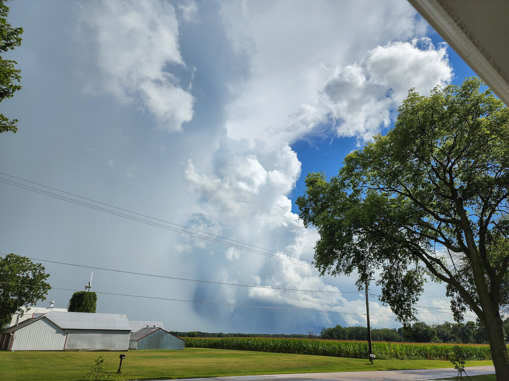
Love the contrasting colours and the mid-day bightness, love that pic.
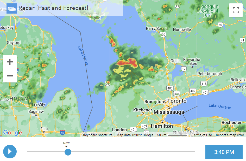
Low was a higher than avg 19C/67F overnight. I'm finally getting a long downpour making up for the misses last week and I'm at 20mm / 0.79in. It was a cluster of heavy showers (minimal thunder) and now this is an unique radar look:
-
I'm only getting some brief, light showers during these pulse storms nearby this week, my station doesn't even record any amount of rain but I suspect its more than 0.1 mm. Heard some thunder on Weds and today. I missed the heavy stuff very close by.
-
Getting pretty messy out there, got my first t-storm since April, ah snap. Torrential rains multiple times over the last 45 mins that I haven't seen for a long while. Got 15 mm/0.6 inches in mere minutes. Only had a few bright flashes but randomly at several points I'd see clusters of frequent lightning then nothing for minutes.
-
At 88F/31C with mostly cloudy skies, not a combo that happens much. Very breezy.
-
15 minutes ago, nwohweather said:
If I’m not mistaken that was followed by an active Fall severe weather season as well. I remember 2018 being a pretty hot year as Toledo reached 90° 44 times which is impressive as hell considering it’s proximity to the lake.
What I couldn’t imagine up there would be the heat waves during the Dust Bowl. I’d love to see what those surface maps looked like with the Great Plains essentially being Phoenix East.
I do say all of this by the way while sitting at my pool in Charleston with current conditions of 91°/77° so I’m definitely jealous of your June-August climoUsually terrible summers like that one have a bit of a balancing out with a warmer Sept or Fall, also some nice Springs like in the 70s. June-Aug climo is good here but you have decent Spring/Fall where here we don't. 3 good months out of 12 still means a sucky climate here near the Lakes in SON.
-
On 7/2/2022 at 4:15 PM, Powerball said:
As bad as July 2009 was, it still could have been worse (1992).
So glad I was too young to remember the stench that was the summer of '92
-
 1
1
-
-
21 hours ago, Chicago Storm said:
@Hoosieris going to hold on to the 18z OP GFS run, and never let go.
Save worthy run, Hr 372 is particularly wicked *chef's kiss*
-
I managed to get through the entire month of June without a single t-storm or clap of thunder.
Yesterday and today's temp trend will set the perfect indoor conditions; the temp started falling faster than usual at dusk but then leveled off at a nice 22C all of overnight, 3rd warmest overnight period. It got to its lowest once the pesky rain started at 8:30 am. No storms forecast for the rest of the day, I'm not complaining.
-
There remains a signal within the various model output that the
   environment may become marginally conducive to organized convection,
   including supercells, in a narrow corridor north of the
   international border (across parts of southeastern Ontario into the
   St. Lawrence Valley) by late Friday afternoon.  However, given the
   rather weak forecast boundary-layer instability across this region,
   it seems probable that this activity will tend to weak as it spreads
   into a less unstable air mass near and southeast of the
   international border Friday evening.
July 1 in S/E ON.
I got 6.6 mm of rain this morning. Nice evening now.
-
22 hours ago, Torchageddon said:
I was suppose to get light showers this morning and then chance of storms later on, I woke up to sunny breaks and turns out, no rain at all!
 Temp over-performing too because sunny breaks in the overcast. It would be hilarious if I can get through another heat event without any storms but today I'm getting July 8, 2007 vibes with this overcast and muggy Sun afternoon. A F1 tornado that was photogenic touched down 20 mins away from me and it was also a unicorn Supercell that went due south from the peninsula that brought me the worst hail storm I've ever seen here, including the absurd report of tennis ball sized hail in Harriston. I'm not snoozing on today.
A few cells near London and Stratford ON that formed like the HRRR showed but nothing here! This isn't the June I'd experience as a kid, no endless dry cold fronts lol. High chance that I go the whole month without a single t-storm as the next chance is July 1...wow. I had a storm in March.
Current temp at 61F feeling like 59F, yes after having some of the hottest days in recent memory I'm getting a friggin' windchill! One of the most rollercoaster Junes.
-
I was suppose to get light showers this morning and then chance of storms later on, I woke up to sunny breaks and turns out, no rain at all!
Temp over-performing too because sunny breaks in the overcast. It would be hilarious if I can get through another heat event without any storms but today I'm getting July 8, 2007 vibes with this overcast and muggy Sun afternoon. A F1 tornado that was photogenic touched down 20 mins away from me and it was also a unicorn Supercell that went due south from the peninsula that brought me the worst hail storm I've ever seen here, including the absurd report of tennis ball sized hail in Harriston. I'm not snoozing on today.
-
I'm at 92F so far, I got to 90 before noon. Can this be one of the hottest days I've had?
-
This is the 3rd day in a row with blues skies, pretty much the best wx during the year here. Temps are just perfect keeping things comfy at 88F for a high with modest lows/low DP so things don't become too oppressive. TWN forecasting another 34C/93F high with some humidity tomorrow which is kind of wild. Can we turn this into another infamous week like June 2020 featured?
-
1
-
-
1 hour ago, Snowstorms said:
Hit 95 both yesterday and Tuesday in Toronto. Humidity had us feeling close to 110
") Broke the daily record both days.
Broke the daily record both days.
Need some rain though, it's been really dry since Spring.
I'm very surprised Toronto got to 95 yesterday, I only got to 83. The early evening got cool and dry.
-
Perfect summer solstice day, I'm at 30C with DP of 20C! Blues skies. If only every day of the year was like this.
-
TWN is forecasting the hottest temp IMBY in years of 34C/93F with a humidex of 42/108! On Wednesday when they set my high to 31C I actually got to 35C; I'm hoping I get to the 100F mark somehow later tomorrow. After that amazing low on Sat morning of 5C/41F I'm looking forward to this.


October 2022 General Discussion
in Lakes/Ohio Valley
Posted
Would be a great Canadian Thanksgiving, maybe I could swim in the lake but the last few days probably wrecked the ssts.