

mimillman
-
Posts
3,333 -
Joined
-
Last visited
Content Type
Profiles
Blogs
Forums
American Weather
Media Demo
Store
Gallery
Posts posted by mimillman
-
-
11 minutes ago, Hoosier said:
Frankly it would be shocking if it doesn't come back west, given the overall synoptic pattern and land breeze asserting itself tomorrow evening/overnight.
Think Michigan gets in on some too, at least extreme SW portion of the state
-
8 minutes ago, Hoosier said:
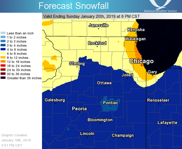
LOT goes 2-5" for Cook, 3-6" and locally higher for Lake/Porter.
Interesting evolution on the 3km NAM as well with the very clear move back west
-
MKE extended the warning to midnight for their SE lakeshore counties
-
10 minutes ago, janetjanet998 said:
REA FORECAST DISCUSSION...UPDATED
NATIONAL WEATHER SERVICE CHICAGO/ROMEOVILLE, IL
1051 AM CST SAT JAN 19 2019
UPDATE
1045 AM CST
THE WINTER STORM IS GRADUALLY ENDING ACROSS THE AREA, WITH MUCH OF
THE WINTER STORM WARNING LOOKING TO END ON TIME. STILL, BANDS OF
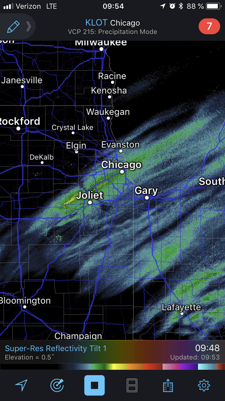
HEAVIER SNOW OCCASIONALLY ARE SEEN IN THE DEFORMATION AREA OF THE
DEPARTING SYSTEM. ONE SUCH BAND IS JUST SOUTH OF I-55 OVER THE
CHICAGO METRO INTO GRUNDY COUNTY AS OF 1045 AM. ANOTHER COUPLE
SUCH BANDS MAY BE SEEN SOUTH AND EAST OF THERE BEFORE ENDING BY
EARLY-MID AFTERNOON, GIVEN FRONTOGENESIS AND DECENT INSTABILITY
ABOVE 600 MB (AS OBSERVED ON 12Z DVN AND ILX RAOBS). DISORGANIZED,
LIGHT LAKE EFFECT SNOW SHOWERS ARE EXPECTED FROM TIME TO TIME IN
NORTHEAST ILLINOIS THIS AFTERNOON WITH LITTLE ACCUMULATION FROM
JUST THAT.
IN TERMS OF BLOWING SNOW AFTER THE FALLING SNOW, REPORTS FROM LAW
ENFORCEMENT AND WEBCAM IMAGES THUS FAR HAVE NOT SHOWN MUCH FOR
REDUCED VISIBILITY OR MAJOR ROAD IMPACTS. WILL CONTINUE TO CHECK
WITH LOCATIONS AS THE SNOW ENDS. IF THE MESSAGE IS STILL JUST
PATCHY BLOWING SNOW MAINLY IN OPEN LOCATIONS, WILL JUST CONTINUE
THAT IN THE FORECAST WITH NO ADDITIONAL HEADLINE NEEDED.
CONTINUE TO ASSESS THE LAKE EFFECT SNOW SHOWERS, AND THE
LIKELIHOOD OF A MODERATE TO STRONG SINGLE BAND LATE EVENING INTO
OVERNIGHT IN NORTHEAST ILLINOIS, AND THE BEHAVIOR/PIVOTING OF THIS
LIKELY INTO NORTHWEST INDIANA SUNDAY MORNING. A WINTER WEATHER
ADVISORY MAY BE NEEDED FOR A PERIOD OF HEAVY SNOWFALL WITH THIS
AND QUICK ACCUMULATIONS OF THREE PLUS INCHES, ESPECIALLY LAKE AND
COOK COUNTIES IN NORTHEAST ILLINOIS, AND LAKE COUNTY IN INDIANA
MAINLY FOR SUNDAY MORNING.
Yes, prudent.
-
-
This band right over the city is cranking! Starting to cover the roads again
-
1 minute ago, ILSNOW said:
Recently from LOT

Noice
-
Lake effect band starting right on time around Sheboygan, WI
-
Just went outside. Impossible to measure with the wind but looks around 5”. Drifts are certainly around a foot if not more.
-
Just now, Baum said:
i got a call for 2" in my grids
I’ve got 2-4 tonight and 1-2 tomorrow. I think 3-6 is the right call for the band, which I think merits an advisory at least. I would throw Cook, Lake, and Porter counties on that.
-
Still no word from LOT on the lake effect this evening/tomorrow
-
4z HRRR says to southern cook “no sir you shall not go quietly into the night. No you shall not be subject to laughter again by your northern counterparts. Yes you shall have the synoptic snow and yes you shall have the lake effect.”
Direct quote of course
-
Just now, zinski1990 said:
Used to it Big snowstorms hate indy
Cept’ for last week tho
-
Lake county IL is golden.
-
Some one in SE Wisconsin just got a s**t ton of snow in the past couple hours. Any reports?
-
4 minutes ago, Baum said:
other models besides the NAM showing this?
Even the GFS
-
There will be at least 12 hours of solid lake effect over NE IL and NW IN tomorrow
-
1 minute ago, StormChaser4Life said:
You always seem to luck out with every storm. Lol. QC area looks to get in on some intense repetitive banding
That area missed out big time past few years. They’ve been making up for it this year and last. Good thing, cause soon the snow will head back to the lake where it belongs

-
 3
3
-
-
I wonder if those who drew the Illinois/Wisconsin border knew they’d be drawing a snow magnet
-
 1
1
-
-
1 minute ago, Chicago Storm said:
A late first call of 12" at ORD...but think I might bust low.
I think that’s high tbh, but could see those amounts by the lake if you get lucky
-
SN- Lincoln park
-
Curious if anything is happening under those returns in SE Wisconsin. Nada downtown rn
-
10 minutes ago, CoalCityWxMan said:
3” increase in totals says the HRRR over the last 3-4 runs. But like you said, southern Cook could only see 3” while northern Cook sees 7-8” (not including LE, just talking about the next 20 hours)
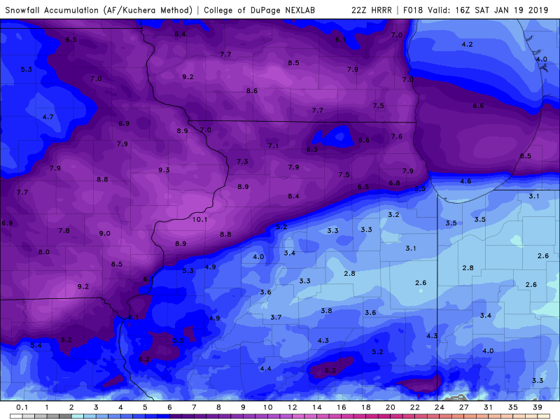
The 22z RAP is not quite as punishing, but has a similar look.
Someone over Northern Cook/Lake county will do very well with this system + lake effect
-
1 minute ago, toddrix1977 said:
LOT is still being very aggressive with their storm totals near the lake. This includes lake effect.
If the 22z HRRR is right the cut off is going to be extreme in Cook county
Winter Storm? Jan 18-19th, 2019
in Lakes/Ohio Valley
Posted
Looks further south then most models suggested.