

mimillman
-
Posts
3,468 -
Joined
-
Last visited
Content Type
Profiles
Blogs
Forums
American Weather
Media Demo
Store
Gallery
Posts posted by mimillman
-
-
00z GFS is about 6 hours too fast on the southern stream for a phase. About as close as you can get without a result.
-
 1
1
-
-
7 minutes ago, IWXwx said:
It's a Hoosier/sbnwx85/Hillsdale/Michsnowfreak special. I want pics.
Drifts have got to be at least 3” in the bullseye. It’s gonna be a doozy.
-
 5
5
-
-
11 minutes ago, Hoosier said:
What more do you need

South Bend crusher
-
1
-
 1
1
-
-
3 minutes ago, RogueWaves said:
I haven't found this lack of sampling to be such a game-changer lately. For instance, the OHV slider that the GFS (and others) had as more of a panhandle hook. The slider look was pretty much dominant by other guidance prior to the wave getting ashore, and once it did there wasn't some massive last-minute shift. More or less just nailed the coffin on any last glimmer of cutter/hooker outcome. These last few winters have been underwhelming. Stretching avg snow totals out over a 6 month period with little staying power of any accumulations is no way to run a season. Give me the avg snow total condensed to 2 or even a solid 3 month period. Better yet, an above average amount compressed into same time frame. This is not only yawn-worthy, it's tiring, and almost a waste of time chasing ghost storms on guidance trying to guess which 1 out of 20 threats isn't just another mirage. Has to be better ways to spend one's time; like numbering the shingles on my roof perhaps..
Multi year bad stretches happen, that’s not new
-
Not terrible if you’re just looking for an active pattern.
-
26 minutes ago, Hoosier said:
If anybody is holding out hope for the weekend system, the northern stream vort that will play an influence won't be in the US until early Friday (Canada for tomorrow's runs).
Clearly no development of a secondary this weekend means suppressed Jan 6-7.
-
51 minutes ago, Hoosier said:
Still have poor agreement on the 12z runs.
I hope the 12z Euro looks like the 6z run.

Euro kinda screwed the pooch on this one lol
-
00z Euro with a Toledo special this weekend
-
30 minutes ago, UMB WX said:
Look at that LES signal
Lol what
-
23 minutes ago, RCNYILWX said:
Cross posting from January thread:
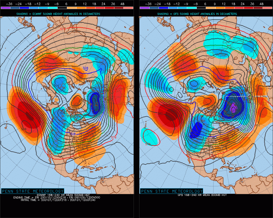
Can say with reasonable confidence that January will be active. The big question is how persistently amplified the southeast ridging is and the placement of Aleutian/AK ridging. Getting the ridging farther east into the EPO domain could make for a more than serviceable month for central, western and northern portions of the sub. Farther south and east could certainly be dicey if this weekend and next week's possible window is not cashed in on. The January-February 2019 500 mb composite anomaly below and sensible weather results shows that the general idea being forecast by the longer ranges of the ensembles and Euro weeklies can work out really well for portions of the sub.
On the other hand, a too amplified southeast ridge and Aleutian ridging too far west could make for a warm/rainy active month for much of the sub and congrats MSP and north/northwest. I don't think we can yet for sure that the MJO being forecast to go with amplitude into the warm phases makes it a lock that it'll be a trash pattern even central and west, just that the warm risk is certainly there. If I'm recalling correctly, a good chunk of last January and February was spent in the warmer MJO phases. This shows it can work out for some of us, but did also make for the bad winter farther east and southeast in the sub and points east.
Also, I'd much rather have an active month biased warm that at least gives a chance for things to break right for a good event than endless cold and dry. Experience shows us that for a big dog we need at least some southeast ridging. The oscillating going on in later ranges of the EPS shows that we'll be on the edge so we'll have to wait and see which way things are leaning. Finally, with the likelihood of stout low level cold air masses northwest of here and warm press from SE ridge, we'll also have to watch for sig icing events in the battleground zone, similar to last February.

Sent from my SM-G965U using Tapatalk
10/10, can’t agree more
-
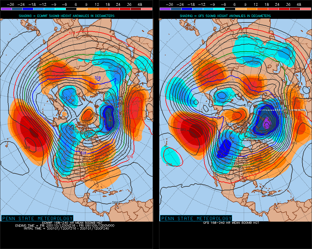
Great run for a large part of the sub forum on the Euro. PV over Alaska is deadly. PV over Greenland, much more workable at least.
-
 1
1
-
-
Got about an inch here. Biggest snow since Veterans Day
-
1
-
-
1 hour ago, Hoosier said:
mimillman -- ORD would need a high tomorrow of 38 to tie and 41 to break November's average high temp. Not happening, but still rather impressive to have the December 2019 average high temp be that close to November.
Too bad. It was a good fight. Thanks for the stats updates.
-
Flizzard downtown. Heaviest snow in a month and a half :p
-
2
-
-
More zonal look on the 8-10 day now. Will take that any day over this horrendous pattern. At least there will be opportunities to work with.
-
Goofus says winter is here
-
2
-
-
9 minutes ago, Hoosier said:
Pretty crappy overall though as it kind of gets sheared out.
It’s so far out, shouldn’t be reading too much into it. What does matter is the much better looking pattern consistently shown in the 8-10 day range.
-
2
-
-
24 minutes ago, Hoosier said:
Yes, it can and has happened. Dec 2012/Jan 2013 was brutal in Chicago. More recently, Jan/Feb 2017 took futility to a new level with 0.6" TOTAL.
Was so glad I wasn’t here in 2017. I had briefly moved back to New York and we did decently well.
I do remember 2012-2013 and it was horrendous. I think there was a clipper train in Feb 2013 which was the only saving grace.
-
Much better look on the Euro long range again. Placement of the Aleutian ridge looks solid. A bit further East would do wonders.
-
3
-
-
In the decade, my favorite event was probably the Super Bowl Blizzard in 2015. Granted I wasn’t here for GHD, but 19” in Chicago in a single event is obviously very hard to come by.
-
3
-
-
1 hour ago, Hoosier said:
Or what if it ties again like Nov/Dec 2018. That would be something.
Here are the stats for the 4 years when Dec avg high exceeded Nov average high. It's 4 times, not 3... I missed 1877 earlier.
Nov 1877: 46.2 ; Dec 1877: 49.1
Nov 1889: 43.1 ; Dec 1889: 47.2
Nov 1891: 39.4 ; Dec 1891: 41.6
Nov 1959: 41.3 ; Dec 1959: 41.5
Wow, 1800s Decembers were WARM.
-
16 minutes ago, Hoosier said:
I am getting a monthly average high temp of like 41.4 when plugging in the high of 61 from today and LOT's forecast high temps at ORD over the next 5 days. Double checked it and came up with the same number so not sure why the difference. Looks like it will be close in any case.
Ah, I wasn’t using ORD, that’s the issue. Still, a risk of over performing on the temperature ahead of the weekend storm pretty much gets us there. Will be very close, kind of rooting for it so future generations understand how s**t this December was.
-
1
-
-
10 minutes ago, Hoosier said:
November average max temp has been colder than December average max temp 3 times in Chicago -- 1889, 1891, 1959. There was a tie in 2018 with both months having an average high temp of 39.7F.
As far as this month... through December 25, the average high temp is 40.0. November 2019 had an average high temp of 41.6. My gut feel based on the upcoming forecast high temps is that this month is probably going to come up short of last month but somebody would have to run the math.
Including today, average high temp Dec 26 - Dec 31 will be just shy of 50 degrees.
That would bring the average high temp in Dec to 41.9, which breaks November. Very real chance we get there.
-
 1
1
-
-
Serious question: has average high temp in November ever verified lower than average high temp in December?
Follow up question, how far away are we from that happening this year?

Winter 2019-20 Medium/Long Range Discussion
in Lakes/Ohio Valley
Posted
Yea that was a horrendous run