

HIPPYVALLEY
-
Posts
32,949 -
Joined
-
Last visited
Content Type
Profiles
Blogs
Forums
American Weather
Media Demo
Store
Gallery
Everything posted by HIPPYVALLEY
-
Cloudy? It’s full sun and blue skies in Greenfield.
-
Looks like maybe another cool down next week then hopefully Labor Day weekend is summer like.
-
We got down to 52° here. Maybe Valley did better than hilltops?
-
Left the window fans on and the living room was down to 65°.
-
I was on Cape Cod this week and the water bans are being enforced. Town of Falmouth is following people’s water meter readings and actively driving around looking for green lawns and watering going on.
-
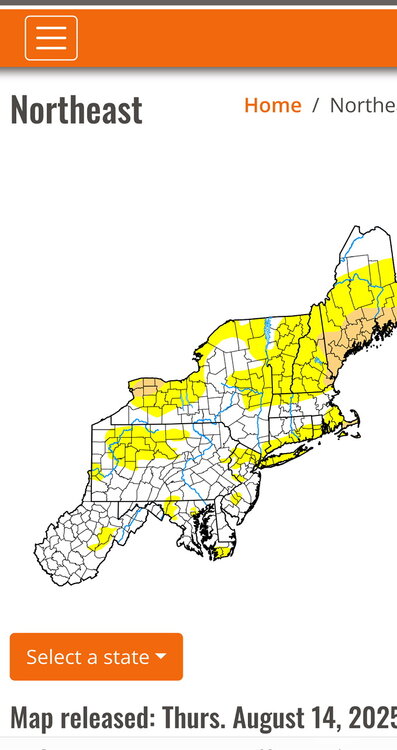
Some of us could be in moderate drought, heading into the autumn.
-
Yesterday‘s rain shower helped ensure extra streamy today. 88/72
-
Awesome, enjoy six months of November before Wiz starts his countdown to May 1 disappointment thread again.
-
The gauge in my yard was .80” so believable.
-
Absolutely poured here, still moderate. Nothing like a quick .40” to water the yard.
-
Nice isolated shower here. Couple of rumbles.
-
Always take the over on temps under on rain.
-
Savannah and Hilton Head rarely get hit by hurricanes. David in 1979 but only Cat 1.
-
Got down to 56° in Falmouth. Chilly with the fans going. Water restrictions are already in place here.
-
Maybe some big un’s
-
That should get parts of Northern and Western New England moving into moderate drought territory.
-
This has been the warmest week of the summer. I’m in Falmouth and it’s even pretty gross here with regards to HI.
-
Wow, I only had about 2.25” in July and .20 mtd August.
-
The whole area along RT 2 from you to N Adams is super dry.
-
Hippy knew it was coming.
-
Had a few rumbles this evening but Sahara conditions continue.
-
91° in Greenfield, but definitely feels more oppressive than yesterday.
-
My hood had them in the spring, then did not see them for quite a while and they were back flying around this week.
-
Got down to 62° this morning. Did fans and windows last night to take a break from the AC.
-
Ya’ but this week is going to be the champion of the summer even if there have been higher heat indexes.


