.png.5608f5bab30d37cac5ee5443be92fc2f.png)
HIPPYVALLEY
-
Posts
29,441 -
Joined
-
Last visited
Content Type
Profiles
Blogs
Forums
American Weather
Media Demo
Store
Gallery
Everything posted by HIPPYVALLEY
-
I may never have to install .
-
So much snow.
-
Long range is looking BN temps which would be ok if it was going to be dry but looks like that won't be the case.
-
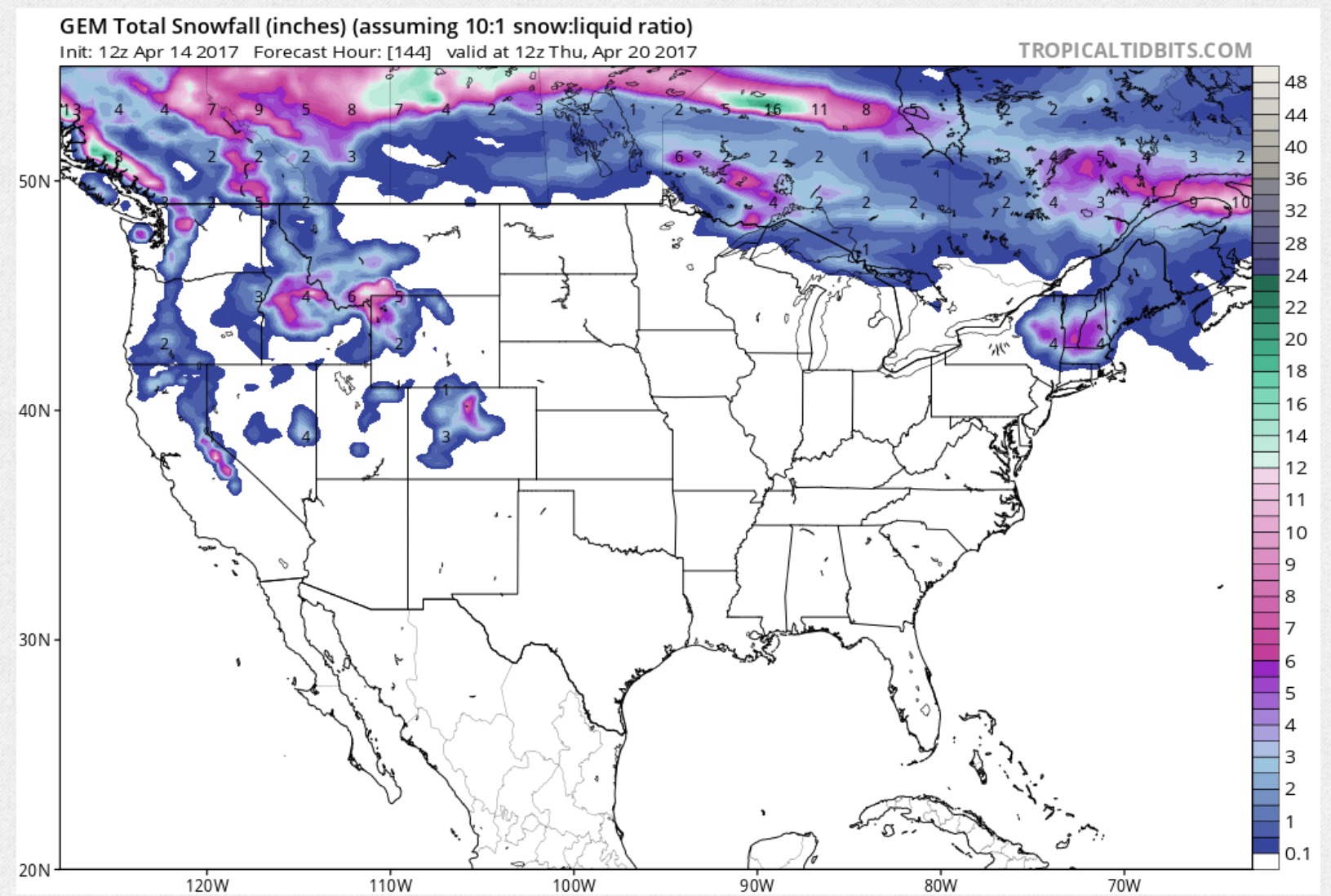
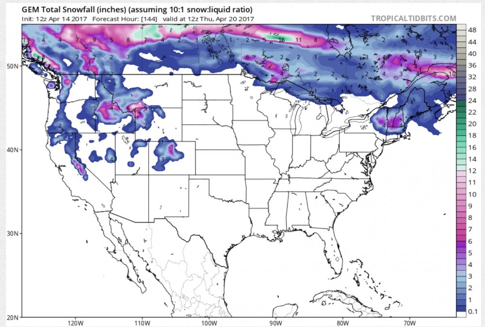
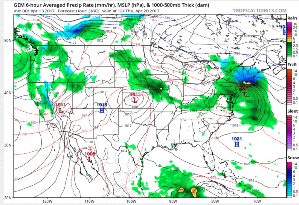
The GFS and the Canadian want to keep Sugarloaf skiing until June.
-
Aside from oppressively humid days I love summer but there are things I love about all of the seasons. I'm even digging today despite it being overcast and a bit cool here. I pretty much won't have long pants on again until October. ...unless it snows next week.
-
Tulip terminator. If only it was more than a Canadian phantom storm.
-
April can often be quite nice in W MA.
-
I think we had about 3" here while parts of ORH Co. 25mi from here had over 20". Toaster bath.
-
I'll be camping at 2000' on the East Slope of the Berks tomorrow night with no light pollution, just hoping the clouds aren't rolling in.
-
.thumb.png.a39dd6246063eee0ff2057401bdf7402.png)
Forecast/storm discussions and part II Manitoba Mauler
HIPPYVALLEY replied to Damage In Tolland's topic in New England
Springfield to Holyoke over to S. Hadley/Amherst can be pretty bad sometimes but the rest of the Valley does fine. Greenfield to Brattleboro is usually ok and even the outskirts of Northampton ends up doing better than those areas. -
Forecast/storm discussions and part II Manitoba Mauler
HIPPYVALLEY replied to Damage In Tolland's topic in New England
Didn't see this posted yet, good read. http://thevane.gawker.com/why-nycs-historic-blizzard-didnt-live-up-to-the-hype-1681962448 -
Forecast/storm discussions and part II Manitoba Mauler
HIPPYVALLEY replied to Damage In Tolland's topic in New England
Yeah, biggest forecast fail I've ever had but still a net gain so gotta' appreciate it and move on. -
Forecast/storm discussions and part II Manitoba Mauler
HIPPYVALLEY replied to Damage In Tolland's topic in New England
4", may not make warning criteria here. -
Forecast/storm discussions and part II Manitoba Mauler
HIPPYVALLEY replied to Damage In Tolland's topic in New England
I think one of the reasons totals are reduced out here is poor snow growth not just qpf issues. Baking powder, I just shoveled and it's surprisingly heavy. -
Forecast/storm discussions and part II Manitoba Mauler
HIPPYVALLEY replied to Damage In Tolland's topic in New England
Yeah, kind of unfair, the radio DJ's are having a field day taking calls from people berating the weathermen. Same reactions on FB. -
Forecast/storm discussions and part II Manitoba Mauler
HIPPYVALLEY replied to Damage In Tolland's topic in New England
Why would NWS still be sticking to their guns on totals? -
Forecast/storm discussions and part II Manitoba Mauler
HIPPYVALLEY replied to Damage In Tolland's topic in New England
Just getting going. I can't imagine BOX is risking busting badly in their 11pm update for W MA. Obviously riding the stall into the sunset: URGENT - WINTER WEATHER MESSAGE NATIONAL WEATHER SERVICE TAUNTON MA 1109 PM EST MON JAN 26 2015 ...A CRIPPLING AND POTENTIALLY HISTORIC BLIZZARD WILL IMPACT THE AREA MAINLY TONIGHT LINGERING INTO EARLY WEDNESDAY... MAZ002>004-008>011-026-271215- /O.CON.KBOX.WS.W.0003.000000T0000Z-150128T0600Z/ WESTERN FRANKLIN MA-EASTERN FRANKLIN MA-NORTHERN WORCESTER MA- WESTERN HAMPSHIRE MA-WESTERN HAMPDEN MA-EASTERN HAMPSHIRE MA- EASTERN HAMPDEN MA-NORTHERN MIDDLESEX MA- INCLUDING THE CITIES OF...CHARLEMONT...GREENFIELD...ORANGE... BARRE...FITCHBURG...CHESTERFIELD...BLANDFORD...AMHERST... NORTHAMPTON...SPRINGFIELD...AYER 1109 PM EST MON JAN 26 2015 ...WINTER STORM WARNING REMAINS IN EFFECT UNTIL 1 AM EST WEDNESDAY... * LOCATIONS...PORTIONS OF WESTERN AND CENTRAL MASSACHUSETTS. THIS INCLUDES THE CITES AND TOWNS OF CHARLEMONT...GREENFIELD...ORANGE... BARRE...FITCHBURG...CHESTERFIELD...BLANDFORD...AMHERST... NORTHAMPTON...SPRINGFIELD AND AYER. * HAZARD TYPES...HEAVY SNOW ALONG WITH CONSIDERABLE BLOWING AND DRIFTING SNOW. NEAR BLIZZARD CONDITIONS ARE POSSIBLE. * ACCUMULATIONS...SNOW ACCUMULATIONS AROUND 18 TO 24 INCHES... WITH LOCALLY HIGHER AMOUNTS. SNOWFALL RATES OF 2 TO 4 INCHES AN HOUR AT TIMES. * TIMING...WHILE THE STORM IS EXPECTED TO LINGER INTO EARLY WEDNESDAY...THE WORST OF THE STORM WILL BE TONIGHT INTO TUESDAY AFTERNOON. * IMPACTS...HEAVY SNOW AND STRONG WINDS MAY RESULT IN WHITE-OUT/ BLIZZARD CONDITIONS WITH NEAR ZERO VISIBILITY AT TIMES. TRAVEL WILL BE DIFFICULT TO NEAR IMPOSSIBLE AND LIFE-THREATENING ACROSS THE ENTIRE REGION. * WINDS...NORTH 10 TO 20 MPH WITH GUSTS UP AROUND 30 TO 40 MPH. THE HEIGHT OF THE WINDS WILL BE TONIGHT INTO TUESDAY AFTERNOON. * VISIBILITIES...ONE QUARTER MILE OR LESS AT TIMES. PRECAUTIONARY/PREPAREDNESS ACTIONS... A WINTER STORM WARNING IS ISSUED WHEN AN AVERAGE OF 6 OR MORE INCHES OF SNOW IS EXPECTED IN A 12 HOUR PERIOD...OR FOR 8 OR MORE INCHES IN A 24 HOUR PERIOD. TRAVEL WILL BE SLOW AT BEST ON WELL TREATED SURFACES...AND QUITE DIFFICULT ON ANY UNPLOWED OR UNTREATED SURFACES. ALL UNNECESSARY TRAVEL IS DISCOURAGED! THIS IS A SERIOUS LIFE- THREATENING STORM! && $$ -
Forecast/storm discussions and part II Manitoba Mauler
HIPPYVALLEY replied to Damage In Tolland's topic in New England
You are going to see some awesome conditions no matter what happens. Good on you for making a road trip. -
Forecast/storm discussions and part II Manitoba Mauler
HIPPYVALLEY replied to Damage In Tolland's topic in New England
I'm not sure what would suck more about having the Euro bust badly, greatly reduced totals from this storm or shattered confidence in the model going forward for the rest of the winter. lol -
Forecast/storm discussions and part II Manitoba Mauler
HIPPYVALLEY replied to Damage In Tolland's topic in New England
Lose the stall? -
Forecast/storm discussions and part II Manitoba Mauler
HIPPYVALLEY replied to Damage In Tolland's topic in New England
Exactly. You'll have some fun in the snow tomorrow. -
Forecast/storm discussions and part II Manitoba Mauler
HIPPYVALLEY replied to Damage In Tolland's topic in New England
I'm not sure people grasp that. I was not even slated for more than -SN until midnight and it looks like what's pivoting in will be at or just ahead of that time frame. We'll see where it goes from there but current obs can sometimes deceive folks from the overall modeled solutions. -
Forecast/storm discussions and part II Manitoba Mauler
HIPPYVALLEY replied to Damage In Tolland's topic in New England
Albany looks to be in some decent returns right now while lesser echoes are East of there. -
Forecast/storm discussions and part II Manitoba Mauler
HIPPYVALLEY replied to Damage In Tolland's topic in New England
I would say it has started. -
Forecast/storm discussions and part II Manitoba Mauler
HIPPYVALLEY replied to Damage In Tolland's topic in New England
Most of the general public wouldn't be. There would be lynch mobs out for the mets. lol