
.png.2082198afdafcedf9ad03f1d6dfb7336.png)
HIPPYVALLEY
-
Posts
31,342 -
Joined
-
Last visited
Content Type
Profiles
Blogs
Forums
American Weather
Media Demo
Store
Gallery
Posts posted by HIPPYVALLEY
-
-
17 minutes ago, w1pf said:
I'm no meteorologist, but if Amherst MA ends up with the 11" that this latest NWS map predicts, I'll eat my snow shovel.
The map is often not updated late into a storm. Amherst will be lucky to break 6"
-
5 minutes ago, CTValleySnowMan said:
For every 10 storms around here it seems as though 6-7 underperform, 2-3 meet expectations, and 1 suprises and that might be generous. I can't blame the western mass guys out of Springfield for being so conservative sometimes. It's usually a zero sum game around here. Either the CCB banding parks itself right overhead or we get a perfect deform for hours or things just crap out and it's arctic sand and when temps are marginal early and late season there is no margin for error. . With most of the biggies it seems as though the beginning of the storm usually starts slow and you feel behind the 8 ball trying to catch up. Just about at climo for the year now so I guess I should be grateful for that.
You nailed it. Up here SWFE are more reliable. I too am am just about climo fir the season. 3 NorEasters in 3 weeks but almost no SN+ to show for it. There is always the next one!
-
5.5" - 6" here since midnight. 4.5" or so otg. Heavy and wet. 32F -SN
A little disappointing relative to forecast but we probably wasted some qpf and never got into better rates despite them being overhead.
Still looks pretty!

-
1 minute ago, JC-CT said:
@Damage In Tolland we probably have until about 4pm to make hay until this pulls out to our east.
Moving pretty fast, and tons of banding, going to be tough for anyone to realize over 18" in SNE.
AWT.
-
 1
1
-
-
1 minute ago, HoarfrostHubb said:
For real? We had one lull in the last hour, but it was brief...I’m closer to the Gardner side of town
Areas between Erving and Gardner have been getting screwed today and that was actually modeled on NAM and a few other models.
-
5 minutes ago, CT Rain said:
It's not snowing hard there yet?
Nowhere in the valley despite a sick look on radar. I have -SN/SN with gorgeous dendrites but can't really get beyond that.
-
8 minutes ago, met_fan said:
Radar shows it directly over Easthampton but it’s light snow here and not accumulation much at allYeah, it must be some phenomenon with the radar, precip rates in the mid level and topography because you would think that the entire I-91 corridor had an insane band parked over it but nobody I know up and down the valley is seeing SN+.
-
1 minute ago, moneypitmike said:
IT's been ripping here for about 2 hours with the wind howling. Deck, car and street are all blown free of snow. I hope people can measure someplace to see what actually comes down. No measurements will work here.
Looks like Pit1 and Hippy are doing great in this.
SN+ and 29* at Pit2
3-4" (4" on non-paved areas.) here due to varying snow growth and borderline temp but I bet your house is 5-7" right now.
-
1 minute ago, Hambone said:
I just measured 9" on my front walk. We had a really heavy band move through with another one building in. Stuck at 31/29.
Wow, much less than that in areas to your West I'm guessing.
-
Just now, Cold Miser said:
Just a real fine snow here. Visibility is not the best, but the snow is just not amounting to much.
We call that baking powder in these parts. It brings meager totals but difficult shoveling.
-
3" or so here. 31F SN little windier than I thought it would be.
There are going to be a lot of disappointed weenies with this banding. People get way too worked over the robust models.
Radar looks great here but I think I am right on the edge of the good banding, literally going from arctic dust to beautiful dendrites every 2 minutes.
Central MA and parts of CT look awful on radar right now.
-
30F Moderate Snow about 2" on non-paved surfaces. Snow growth is decent for the time being. Really sticking to everything so power may be an issue.
-
32/30. Steady light snow. Small flakes.
-
18 minutes ago, HoarfrostHubb said:
Ripping here. Already a new coating. Hubbardston, MA. 9:20PM
Interesting, that stuff is either isolated or under the beam.
34F overcast but looks like a bit coming up from the S.
-
7 minutes ago, ORH_wxman said:
Do you have any maps of January 23, 2005? Still in my top 3 behind 2/78 and 4/97. Over 30" in Cambridge/Somerville death banding. Entire cars covered up and down snow choked streets. Glad I was still in Boston for that one because iirc W MA did not do nearly as well. I just remember people walking around monday morning shaking their heads at how they would dig their vehicles out that had been buried by plows and drifting. Sidewalks in the city were a complete disaster and some side streets were not plowed for hours after the last flakes.
-
I went through that March firehose event in 2013. Fun thread. I definitely was bearish on the 6th for my area, but funny how that changed in 24 hrs. Funny looking back at it....I must have still been jaded from 2011-Jan 2013. It was a tough call on the coast, but the firehose still should have been respected. Tough to get a sh*tty event on the coast with good cold at 925mb and a wicked deep layer fetch from the east.
I think we had about 3" here while parts of ORH Co. 25mi from here had over 20". Toaster bath.
-
I'll be camping at 2000' on the East Slope of the Berks tomorrow night with no light pollution, just hoping the clouds aren't rolling in.
-
you live in spfd or northampton???? its remarkably real for us folk!!! its not overplayed at all in fact its like THE BIG PINK ELEPHANT IN THE ROOM that very few are brave enough to talk about.
Springfield to Holyoke over to S. Hadley/Amherst can be pretty bad sometimes but the rest of the Valley does fine. Greenfield to Brattleboro is usually ok and even the outskirts of Northampton ends up doing better than those areas.
-
All the more reason to have been more conservative back that way. Too much love for the Euro this time around. People I think forget one of the things that makes it so great is its consistency. And even when it's wrong, it can be slow to correct....which is unfortunately what happened here. When it started making small shifts east while several other models had already made larger jumps east, that should've been a clue.
Sent from my iPhone
Didn't see this posted yet, good read.
http://thevane.gawker.com/why-nycs-historic-blizzard-didnt-live-up-to-the-hype-1681962448
-
i agree its def 10 to 1 or less....still though not even half of the lowest amounts on box map.....i never bought 20 inch plus forecasts but i thought we were good for 12 to 15 or so.
Yeah, biggest forecast fail I've ever had but still a net gain so gotta' appreciate it and move on.
-
How much did you measure, Chris?
It's predominately qpf, though. That said, we're now hiavng the best snow of the storm--at least since 5:00a.m. If it keeps up a while this could get us over the hump to reach advisory level.
4", may not make warning criteria here.
-
I think one of the reasons totals are reduced out here is poor snow growth not just qpf issues. Baking powder, I just shoveled and it's surprisingly heavy.
-
in defense , there were some posters that knew something wasnt right and wondered what okx was seeing that they werent....despite all their epic events over the past few years i feel bad for them....it really sucks and were talking a huge area from albany to ttn and phl to hfd/spfd up to greenfield that was promised warning to crippling snowfall amounts
Yeah, kind of unfair, the radio DJ's are having a field day taking calls from people berating the weathermen. Same reactions on FB.
-
You can see that eastern lobe clear as day on the water vapor, I have no doubt there's at least a kink under it.
Why would NWS still be sticking to their guns on totals?
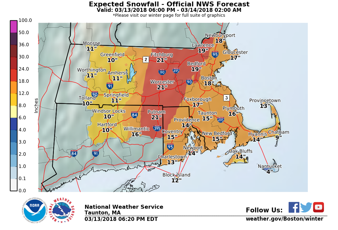
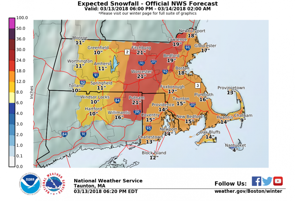
March 12/13/14 Blizzard/Winter Storm/WWA etc
in New England
Posted
Parents and sister say 22"+ in Chelmsford.
Looks like the big totals cut of sharply W of ORH. N Quanbin towns have joined the land of commoners the past few seasons