michaelmantis
-
Posts
283 -
Joined
-
Last visited
Content Type
Profiles
Blogs
Forums
American Weather
Media Demo
Store
Gallery
Everything posted by michaelmantis
-
Looks like the 9:31 AM updates mention 3-5 additional inches in the North parts of IL rest of the storm? That band over the Mississippi River looks nice if it can not miss north! Your office running on coffee and Redbull?
-
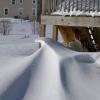
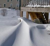
Just got done shoveling. Around 8 inches came down in 5 hours (2 AM to 7 AM). As has been posted, looks like the big snow is over for much of NE IL. So close to something bigger but I'm very happy with what fell so far. Getting a few more inches would be the icing on the cake.
-
After 45ish minutes of light returns and some pingers on the windows, we're back to fat fat FATTIES falling from the sky. Not too heavy, but cotton balls are coming back down. Going to shovel just to try to not have to do it all at once later today.
-
Sounds like a little sleet hitting the windows as this new areas of precip blossoms north of Peoria to Rockford. Looks like I may be in decent pivot point position.
-
That first wave of snow was AMAZING. Looks like precip filling back in around the northern half of Illinois. At least 4-5 inches already.
-
WSW issued for McHenry-Kane-DuPage counties in IL. Note about mix up to I-88.
-
Go back to your wife and tell her you were wrong... It was man yards! ;-) Not getting too excited yet but starting to see the cancelations for schools, daycare, etc hitting my email...
-
Agree with you 100%. Have some family flying out this weekend from O'Hare and 4 inches of snow overnight Friday with wind AM Saturday is just as bad as 6 inches. So the storm gets to a point where it is bad no matter what. The mixing and flake quality is key I think. Get a few hours of rippage and toss in a cooler airmass behind (different from last storm) and some wind and you'll have more impacts even if we get the same amount around here as the Monday storm.
-
Sucks all around. ;-) Either way, I'm betting school canceled tomorrow for my kid and whatever falls will turn to solid ice over the weekend. That I'm assured of. Going to catch up on this later today as it becomes more real.
-
My location on the NAM map you posted. Talk about the teeny-tinesy screw hole imaginable... I'm going to try to forget about this thing until the afternoon AFDs.
-
At this rate going from 10 inches to 6 inches (or something "more reasonable" if the track does move a bit E) isn't a loss for me given the past few years. The "big one" will be a surprise I'm sure! ;-) If the wind starts up Friday night, just a few inches will be bad. Eurythmics posted often, but for us this is a better song... You Can't Always Get What You Want - The Rolling Stones
-
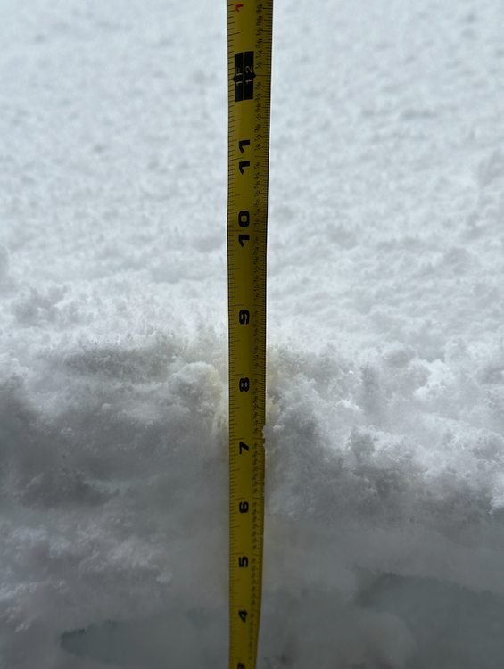
3ish inches at the end. It all compacted down so much can't really tell. But there was a few hour period where the cotton ball flakes added to at least 3 inches on their own (before compacting down).
-
I'm 5 miles south of where you will be. The last storm had the front end precip a sloppy mess (my backyard was full of slush) but the backside was *nice*. Best flakes I've seen in years. Parts of the Fox Valley (Aurora for example, 15 miles south of Algonquin) are notoriously a few degrees cooler in the dead of winter. We are far enough away from the Lake that usually lake warming doesn't hurt us that much. But we have got a few Lake bands when all the stars align. Provided the low doesn't make some crazy big jog north, the lake "warming" will be less of an impact out here.
-
The AFD update was great. Nice putting the "Forecast Uncertainty" in there too... As to the timing... You guys were spot on with the N IL impacts of the last storm between 12-4 PM. My daughter's school canceled classes and at 11 am it looked like things were not that bad on the roads. But from 11-3 it just RIPPED here (Northern Kane County in Elgin - 3 miles south of I-90) and the roads were awful. Buses (especially in my rural area) would have had a hell of a time. Looks like the hourly forecast for the next storm has the snow really starting around me by 8 AM Friday and going through the whole day. In your 100% "not representative of the US Government" opinion ;-) it is looking like the second snow day this week for my daughter? I've said it before, your posting here is so awesome. Thanks for taking the time.
-
I just got back from my parents in Arlington Heights / Des Plains area and the difference in snow in just 15 miles (as the crow flies) where I'm at was clear. Now how far will the lake impact things is one of the big questions (low placement obviously too!)
-
(Not sure if this is too off topic) Didn't the NWS split Cook county into a North and South warning zone for Thunderstorms recently? And one would think there would be some split for areas near the Lake in situations like this.
-
Winter Storm Watch posted by LOT...
-
I just want more "snow" and not "slop". I just got done shoveling 2 inches of compacted ice at my parents house (that they didn't get to shovel yesterday).
-
I'm riding the knife's edge at that pivot point keeping me in the money for a few hours longer.
-
Entire event changed here about 2 hours ago. The front end precip was sloppy and rates weren't that good. The last two hours have been totally ripping. Going to shovel the driveway so the slop doesn't freeze or get any thicker. Not looking forward to the single digit highs that may come around early next week.
-
The slop finally is hidden by actual snow. Been going pretty good for a half hour or so. Best flakes of the event so far.
-
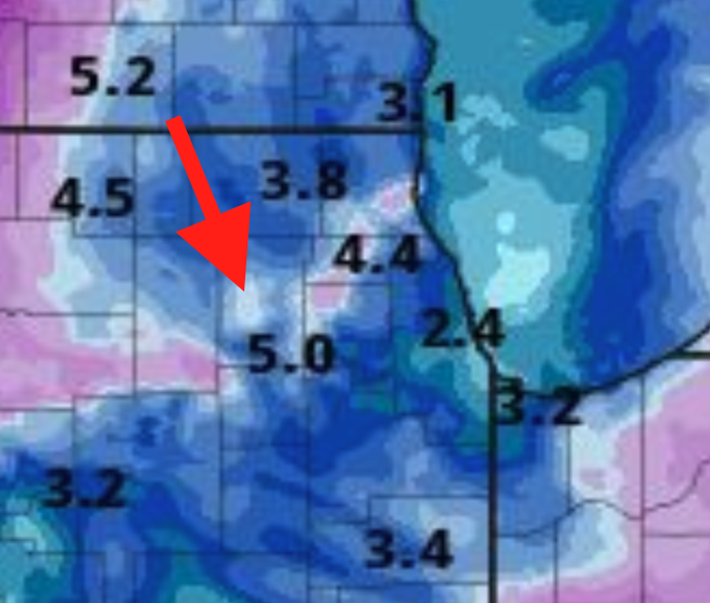
So how do the updated grids (which has me at 5-10 for the next 24 hours based on the update Borchardt seems to have done a few minutes ago) match up with this posting from 8:51 PM that shows 8-12 (based on the Probabilistic Forecasts)? Not knocking anyone, just wondering how different numbers can come from a NWS office within an hour of each other and it looks like Borchardt published the 8:51 PM update too? https://www.weather.gov/lot/winter
-
Wow... Cliff's notes version reading the 822 PM update pretty much is "the snowfall guidance from the prior shift is way too high but the impacts are the same." Flakes in Elgin started around 9:30 PM.
-
So what is your level of interest? ;-) Considering the 2 inches we got last night was the highlight of the season so far, anything more than that *has* to be exciting for all of us! :-) I'd be not hoping/expecting much near the lake in NE IL but someone between Quad Cities and Collar Counties in IL may get a decent 6ish (+/- 2) event.
-
Rain is over-performing here for sure. Thank goodness we are cooling down after this because the humidity would be crazy. Looks like the MI people going to get into the action too. Amazing to see the development of these from nothing to something.