

CAD_Wedge_NC
-
Posts
2,388 -
Joined
-
Last visited
Content Type
Profiles
Blogs
Forums
American Weather
Media Demo
Store
Gallery
Posts posted by CAD_Wedge_NC
-
-
1 hour ago, BornAgain13 said:
Also , has anyone looked at the EPS for the Friday system , actually has right many members with decent accumulations... Allan tweeted about it a little bit ago
Yes, it has trended colder and colder with each EURO run and I don't think it's done yet. This one might have some legs. Have been watching it on the various models.
-
2 hours ago, NorthHillsWx said:
No cold air source. No threat outside of mountains for significant accumulation imo. Verbatim models showing snow only in heaviest returns. Upper levels decent but rate driven snow this far out is just something to cut out the boredom
I understand the skepticism. However, I would not dismiss this one yet. It will be interesting to see the thermals once the higher resolution models come into range. Until then, I will be watching the trends.
-
1 minute ago, Blue_Ridge_Escarpment said:
Still a ways to go but the trend is our friend right now. All Global’s showing wintry here.
Yeah, it looks like an elevation dependent event as of right now. However, it's been trending better for us foothills folks too.
-
 2
2
-
-
6 hours ago, NorthHillsWx said:
Pattern better hurry up
That map will change many times before verification. Stick with the ensembles for long range forecasting.
-
1
-
-
This is going to be a good month. I can feel it.
Currently foggy conditions and 50 degrees
-
19 hours ago, wncsnow said:
It's still generally 5 to 10 degrees above average on non rainy or wedge days. I guess that's an improvement over last year still but we are going to have to wait a while for any snow chances
I'll say this..... if the long range pattern comes to fruition, we will be tracking some big dogs in the next couple of weeks. I have not seen a better pattern than what's being forecasted in many years. This is what we have all been waiting on......
-
5
-
 1
1
-
 3
3
-
-
10 minutes ago, NorthHillsWx said:
Cold without snow is wasted cold
See, now that's where we differ...... Cold weather is needed for the ski industry in the Southern Apps. I don't care if I get 0 snow, as long as it's cold enough for them to make snow. A lot of folks' jobs are dependent on the cold. Let's not be selfish.
-
2
-
-
I don't understand the whining. This winter was supposed to be a wall-to-wall torch. Let's just be thankful we are not looking at a strong SE ridge and 75 degrees everyday. The pattern could be a lot worse.
-
2
-
-
2 minutes ago, PackGrad05 said:
The 12Z HRRR is coming in now. Still showing possibility of flurries over central on Christmas Day. Accumulations are non-consequential, dusting if anything.
NWS not buying it. Not even a mention of clouds in the forecast. Down-sloping makes it almost impossible to get any snow here in the lee.
-
23.9 degrees this morning with a very heavy frost. Even the shrubs are white.
-
1
-
-
50 minutes ago, kvegas-wx said:
Wow, this thing crapped out fast. I can take a defeat or two this early in December. But this better not be indicative of Jan-Mar.
Wait,,, what?.... I am confused....... Oh, I see now, you are talking about Greenville NC. Yeah, CAD storms don't really affect you guys.
-
6 minutes ago, BornAgain13 said:
Is this thing trending less ice here and less snow for mid atlantic... its weird its almost a perfect setup
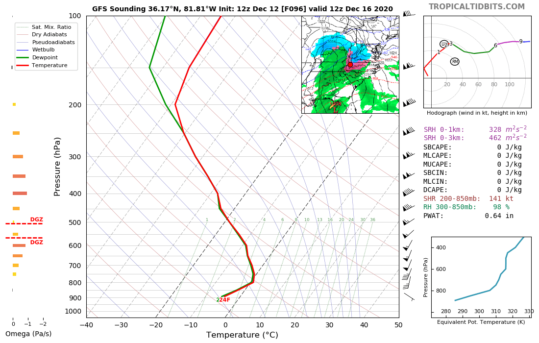
I always look for a number of things to determine whether we will get a freezing rain event or not. This looks to be a very good example for the classical CAD event.
1) You want to see 850 Mb temperatures of -20C in ME (we have that) Check
2) You need that 540 line in Virginia (we have that) Check
3) A 1030+ high pressure around upstate NY (slightly north with this one) Check
4) Soil temps are important as well (no frozen ground with this one) Concerning but not a show stopper
-
1
-
-
6 hours ago, WxKnurd said:
Nope, no CAD for us. Just a cold rain if it’s a true Wedge setup.
Across the NC mtns and higher
 elevations of the Upstate and NE GA, snow will be the main
 p-type, where a few inches are possible across the srn
 escarpment and lower totals to the north. A lot can change with
 this system and the fcst will be adjusted over the next few
 days. One to keep an eye on.
NWS seems to think the higher elevations will be ok.(excerpt from their afternoon discussion) Looking at the 12z GFS soundings, they show a very thin layer around 800mb above freezing up that way.

-
6 minutes ago, BooneWX said:
Imo, Globals struggle with CAD. Tomorrow will be telling with the NAM firmly in range, even though it’ll tend to over do the cad slightly.
I have to agree here. History would tell you that the CMC is better in these situations while the Euro doesn't handle the Cad as well.... I would not get too concerned about the Euro in this instance. As a side note, once we get into NAM range, it will tell us all we need to know about the thermal structure.
-
2
-
-
On 12/5/2020 at 11:57 AM, kvegas-wx said:
Off topic, but anyone heard from Mack since he moved to IA and should already have at least 2 good snows under his belt?
Yeah, he's over on the other forum.
-
19 minutes ago, kvegas-wx said:
NWS took rain chances completely out of my forecast in Winston and took my 50% chance of snow showers out of my Stuart VA forecast at the farm. Says sunny on Monday now. Next!
They removed it from the forecast, but GSP has a pretty good discussion about it this morning. The 12z suite today will be telling. If today's trends are not in our favor, it may be time to let this one go.
-
1 hour ago, magpiemaniac said:
And just like that, this GFS run crushes our hopes. It looked nice on paper though.
Meh.... let's see what the Euro has to say.
-
On 10/29/2020 at 5:52 PM, LibertyBell said:
Also isn't it true that alpine areas warm more slowly and areas close to the oceans are warming much faster because the oceans act as heat sinks? Same reason why the arctic warms much faster than antarctica
Speaking of Antarctica ..... "Ice extent is now well above the 1981 to 2020 median extent. This follows a remarkable transition from generally below median extent beginning in August 2016 to well above median extent just in the seven weeks preceding October 1, 2020". Why are we seeing the shift from near record low extent in the north, to near record high extent in the south? If this is a "global" issue, someone please explain the anomaly with Antarctic ice extent.
-
11 hours ago, WinstonSalemArlington said:
We need this this winter

We will get that look in November of 2020 and again in April of 2021.We can't buy a -NAO in the heart of winter.
-
1 hour ago, burgertime said:
Have to agree....given how the system looks currently and the setup I have a hard time believing it's that extreme.
Burger sighting!...... Glad you're still alive and well. I have to agree here. I am skeptical of the lee-side snow-hole with the trajectory of the precip that's coming in.
-
1
-
-
Had a low of 25 this morning and an afternoon high of 37.
-
06Z OP run doesn't agree with the ensembles.... it's probably a blip.
-
Currently 38 degrees here..... Happy New Year and a happy new decade.
-
Thunderstorm and 50 degrees.
-
1
-
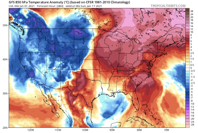
Mid to Long Term Discussion 2021
in Southeastern States
Posted
That Great Lakes HP along with the confluence from the 50/50 low will be the deciding factor in whether or not we have enough cold air and the eventual track. You have to be excited about the trends so far.