

DeltaT13
-
Posts
3,006 -
Joined
-
Last visited
Content Type
Profiles
Blogs
Forums
American Weather
Media Demo
Store
Gallery
Posts posted by DeltaT13
-
-
3 hours ago, BuffaloWeather said:
Glad I was able to go skiing last night. Season might be over.Agree. Just finished my annual three day trip at whiteface and conditions were pretty good but hanging on by a thread. Hard to really recover from numerous rain events over the next couple weeks. I got my fill. Im out. Haha.
-
 2
2
-
-
11 minutes ago, SouthBuffaloSteve said:
Neat…

Oh my!
-
54 minutes ago, rochesterdave said:

Geez I didn’t get more than a dusting on the west side.
-
 1
1
-
-
Saw another good one.

-
 3
3
-
-
3 minutes ago, gravitylover said:
That struck on this side of the state this week. Hey folks! I haven't been in this forum in way too long but now, again, I need some feet on the ground info. We picked up those Indy Passes and we get 2 days each at Greek, Swain, Snow Ridge and Titus. We'll do an overnight but can't get that far out until Wed-Fri next week so where am I most likely to find (what's left of) the good midwinter snow I'm jonesin' for?
Yikes, that's some tough timing. Wednesday looks like the only day you can salvage a decent full day and maybe the first half of Thursday. If I had to go to one of those 4 places and conditions were equal at all of them I would pick Greek Peak hands down.
-
 1
1
-
-
1 hour ago, vortmax said:
As much as I'm rooting for you, I'd rather it be suppressed with a nice shellacking.
Well obviously! I’m just trying to find a silver lining when we get 5 cutters over the next month.
-
4
-
-
23 minutes ago, vortmax said:
NWS BUF put out a HWO for a cutter... seems they've already decided.
They didn’t even mention the best part.. high winds! I’m shifting into wind mode early this year.
-
2
-
-
Gfs has next weeks storm as a major wind event as of the last few runs. If it’s going to cut it might as deliver some big winds too!
-
2
-
 1
1
-
-
1 hour ago, CNY_WX said:
We’ll see snow in April, mark my words.
I don't think I've ever seen an April in my whole life where we didnt get at least a trace of snow. It's way more the norm than the exception for Upstate.
-
5
-
-
1 minute ago, tombo82685 said:
Good to know, but still if you measure right after snow falls that still is fluffed up compared to 6hrs layer going to be different numbers I guess point of my post was
Oh absolutely. If the intervals are set ahead of time, and not set when the snow starts, you can definitely skew numbers in the way you mention. It's the reason all the airports will always have much higher numbers on the season than the general public, 6 hour intervals are very short compared to people waiting 24 or more hours to take a measurement where the first few inches that fell have been squashed down to nothing.
-
1
-
-
53 minutes ago, mississaugasnow said:
Looking back at last years photos to judge snowbank size haha. Last year mid February was packed with snow and created massive snowbanks. The thaw started almost immediately though and by end of February my piles were diminishing fast. March 13th I took the last photo of a tiny remnant baking in the sun haha. By March 20th Toronto had 7 days in a row around 55-65F with a severe thunderstorm warning
I know everyone wants winter to win out but now we're getting to the point in the calendar where changes will start pretty fast.
Last February saved the winter for me. We had 4 inches or more on the ground for the entire month peaking at 18 inches during mid month. Was a hell of a 6 week run that ended just as quickly as it started.
-
3
-
-
38 minutes ago, tombo82685 said:
Yup, esp with lake effect, sublimation occurs all the time. I have a camera on my snow board so if I’m not there to clear I can see max depth. Yes you can bun me.
It's not sublimation changing numbers during the course of 12 hours or so, its compaction. Snow basically never stops falling....its always compacting together more efficiently, that's why glaciers form. Snow will continually settle until its a solid block of ice.
-
1
-
-
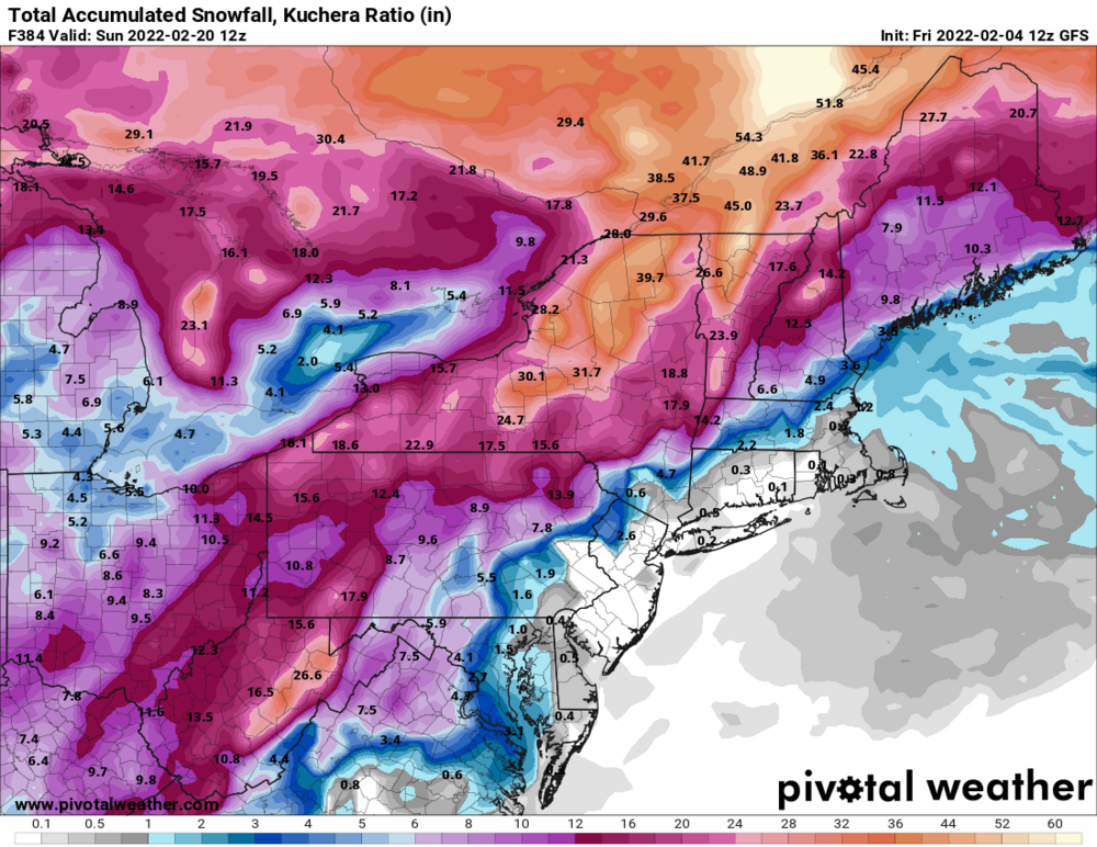
2 hours ago, tim123 said:
Seems like those kuchera maps aren't so dumb.
They only verified for less than 10 percent of our area. There are better maps to use. I ended up with 12”, basically spot on the 10:1 forecast. If I went by a kuchera map, then my forecast busted by nearly 50 percent in my backyard.
-
7
-
1
-
-
15 minutes ago, tim123 said:
You at a foot yet?
I should be right around 12-13”. I’ll update when I get home.
-
We must have added 2-3 inches today. Definitely a solid finish to this one.
-
5
-
-
8 minutes ago, 96blizz said:
TugHill Matt must be heading to Toronto next week....
-
5
-
-
1 hour ago, tombo82685 said:
lowville coop melted down .6 with 8" of snow. Not sure if that liquid number is right, but thats like 30-1 ratios. Seems pretty high honestly.
Recheck your math. 8/.6 = 13:1
-
3
-
-
Right around 10-11 inches total right now but my snowboard location was particularly vulnerable to drifting with this wind so I had to measure a few other less reliable places. Still pretty good consensus around the yard.
-
Well we’ve got something to track! At least for the next 6 hours haha. I’ll be in placid that weekend, what I wouldn’t give…
-
Cleared the board again a couple minutes ago…2.5” of absolute dust, probably 8:1. That brings the daily total to just about 7 inches and I’d take that ~7” of this quality snow over 15 inches of 20:1 any day of the week. Plus it’s now been snowing for 24 hours straight which I really enjoy. Seems like we could get another 2-5 so perhaps a total of 9-12 at this point.
Total on the ground right now is 14” so we start adding days to that interesting daily snow on the ground statistics (12”) that is notoriously hard to tack on any days.-
3
-
1
-
-
I’m out driving around as per usual. Went bowling and dropped friends off downtown. It’s certainly bad but nothing too crazy. Roads aren’t anywhere as bad as that last synoptic system but still fun. Anytime I’m in 4x4 I’m a happy guy. Looks like 6-8 for the most part. Definitely could make a run at 12 if the radar holds.
-
1
-
-
14 minutes ago, TugHillMatt said:
What happened to our colder weather for after this storm? Looks like mid to upper 30s all of a sudden much of next week. What has happened to the days of yore with highs in the 20s and replenishing snow showers?
It’s because last night I mentioned how the extended looked great and we were going to hold this snowpack for a couple weeks. Damnit all.
-
2
-
-
4 inches on the button but high density stuff. Board was cleared at 6pm. We’ll see what we can tack on from now till later tonight.
-
3
-
-
2 minutes ago, PerintonMan said:
Holy s___, Delta, I'm pretty sure we work in the same building.
Well wouldnt that be a fun plot twist! Don't tell them I spend all day on here during storms! I'm trying to think of another weather nerd at this place??
-
1
-
3
-


Upstate/Eastern New York-Pattern Change Vs Tughill Curse?
in Upstate New York/Pennsylvania
Posted
.75” of rain so far in my backyard and it’s hammering right now. Temp is 34.5, changeover will still be many hours away. Awful just awful