

DeltaT13
-
Posts
3,006 -
Joined
-
Last visited
Content Type
Profiles
Blogs
Forums
American Weather
Media Demo
Store
Gallery
Posts posted by DeltaT13
-
-
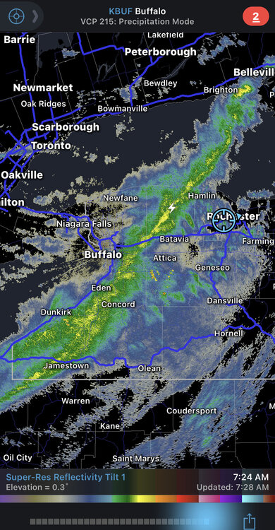
Winds are ramping up nicely in Buffalo. I’m downtown at a hotel right now about to check out (duffs then home!). Seems quite likely that we’ll see some damaging gusts this afternoon. Forecast has temps slowly falling during the afternoon which should increase surface instability as the ground will still be baking in the sun. That’s when we should see the action.
-
These anomalous spring wind events are interesting. I assume it’s the juxtaposition between the ice cold lakes and the dark leafless land which creates a huge horizontal temperature delta that must drive large powerful turbulent circulations. Add in some of large snow fields in the higher elevations and dense wooded areas creating additional localized circulations and it should be and interesting day… as long as we get adequate solar heating.
-
Cautiously optimistic for this wind event tomorrow. It’s actually the type of event that brings the most potential. Bring on the sun!
-
 2
2
-
-
37 minutes ago, Leelee said:
We'll pretend the handful of thaw torches the past few weeks didn't happen.
I have that clown blocked, but I like how he's just going to ignore temps in the upper 60's on Sunday. What a weird existence to troll a weather forum with nonsense for years.
-
4
-
-
2 hours ago, rochesterdave said:
I guess it’s down to me and Wolfie hoping on winter.
I’m all in until April 15th. I’m just a realist and the last few years the show was over starting March 1st.
-
1
-
-
Baseball is too long as it is. Cut two months for all I care. Sounds great to me. 100 game season would be great and still too long IMO.
-
2
-
-
7 minutes ago, TugHillMatt said:
We all know the only thing you saw on there was "81 mph wind gust."
One of my all time favorites. Wish it had been better forecasted. I was working all day…. Such a shame.
-
 1
1
-
-
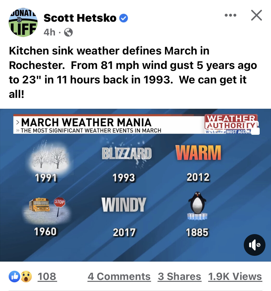
Fun and accurate post from Scott Hetsko. March has the potential for everything.

-
3
-
-
1 hour ago, BuffaloWeather said:
Rochester being 3.6 degrees warmer than Syracuse and 3.4 degs warmer than Buffalo is quite odd. I've said for awhile the ROC thermometer has run low while Buf/Syr have run warm. The truth is probably somewhere in the middle.
Is this a typo? Rochester was warmer than Buffalo and Syracuse?
-
This winter is a solid B for me, teetering on a B+. I have held at least a trace of snow on the ground everyday since January 3rd, with more than 1 inch on the ground for 56 days. Greater than 2 inches on the ground continuously since January 16th. So as a snowpack guy this is about as good as it gets. I chased a decent lake event in Buffalo and a couple real nice synoptic events here in KROC, one of them with absolutely insane rates, so I can't complain. Anyway, looks like the show is more or less over as we hit meteorological spring. We are hitting the peak acceleration of the day length sine wave now as the days are getting longer very quickly and the sun angle sky rockets. Thanks for the memories 2022!
-
3
-
-
1 hour ago, rochesterdave said:
NWS dropped a really anemic advisory on Monroe. 4-7”. Booo. Looks like they buy the EURO.
I mean with the speed of this system I don’t think you can realistically expect much more. A solid 6 inch storm would be fine by me. I’m going to Bristol first thing tomorrow. Pretty big gamble with the mix line so close but the season is quickly coming to a close so I’m rolling the dice.
-
1
-
-
3 minutes ago, tim123 said:
So why no watch out in roc. Odd
I think you need 9 or more for a watch. Seems like a high end advisory event.
-
1
-
-
2 minutes ago, wolfie09 said:
Yeah but they will call it 5"-10" and it will be an advisory lol
I'm feeling like this is a 4-8 event with a couple high end lollies in lake enhanced areas. Kind of straddling the line between advisory and warning but does it really make a difference? Just cover up the grass and mud please. Coastal transfers have been known to disappoint in far WNY so hedge your expectations accordingly
-
3
-
 1
1
-
-
Man it was a balmy 52 degrees and then the lake breeze came plowing through and dropped us 10 degrees in 30 minutes.
-
1 minute ago, tim123 said:
Still looks like its snowing pretty hard near you
Definitely heavy snow still.
-
2
-
-
Just now, tim123 said:
Snow squall warning out
A good 20 mins after it moves through. I don’t usually throw stones at those guys but good grief. Lol.
-
 2
2
-
-
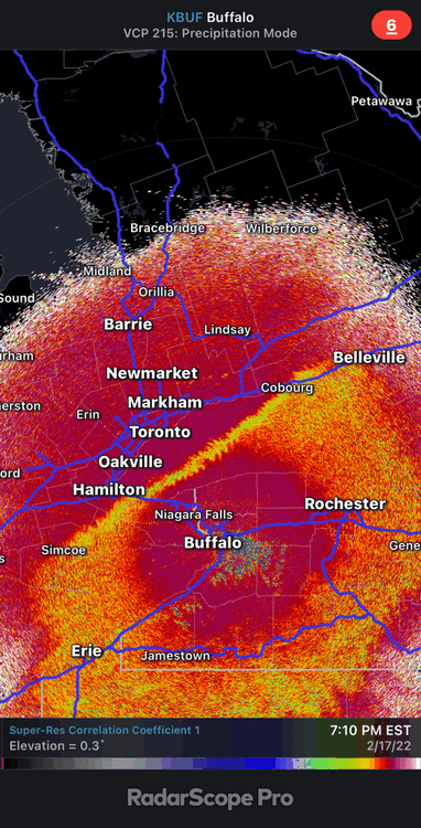
Arctic fronts never disappoint. I went old school and just sat without my phone or any radar updates for 25 mins and just enjoyed it out the windows. Nice start to this Saturday.
-
7
-
-
Still popping some lightning.
-
10 minutes ago, tim123 said:
What will probally prevent big gusts is front comes thru 6 7 am with no daytime heating to mix atmosphere.
I think the front itself has more than enough energy to mix down some strong gusts right as it passes. It then looks like a little lull until you get the max pressure rises, closer to 11-1 where we might get some nice breaks of sun to help out. I’m optimistic.
-
1
-
-
9 minutes ago, tim123 said:
Kbuf should have atleast wwa out for all of western ny. Wind with widespread snow squalls should warrant that. But they never issue those. Also odd they don't have wind advisories for wayne ontario counties but are out east and west of those counties. Bad collaborative effort here.
I agree. WWA would have covered all aspects of this event much better.
-
5 minutes ago, SouthBuffaloSteve said:
Was going to ask your thoughts on timing. Based on radar still looking like the front itself is 10 hours out (45 mph… 450 miles) so 6am ish. Feel the highest winds will only be a 3-4 hour window thinking 4am-8am with the peak period being 6am-7am when the front comes though. Winds have been brisk off Erie this evening already gusting over 30.
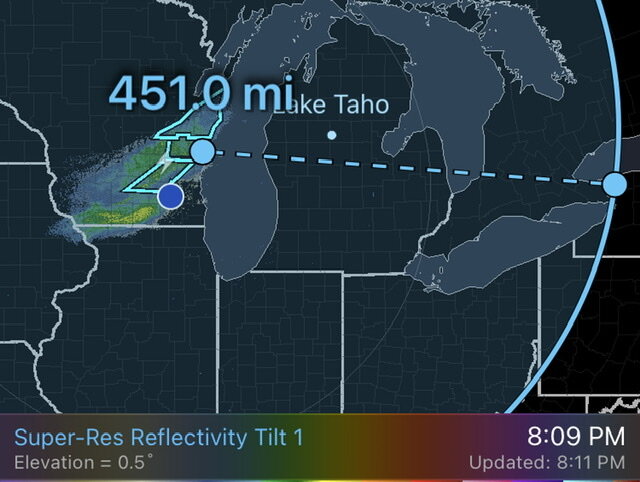
Seems like it might come in two different short windows. 6-8am then 1-3pm.
-
Bit of a head scratcher as to why the wind advisory starts at 1am and ends at 1pm. Seems like 6am-6pm makes a whole lot more sense in regards to the frontal passage.
-
1
-
-
We got way more snow than I expected. Probably close to 4” of absolute fluff. I’ll take!!
-
4
-
-
I hate seeing it actually bump north the last few frames.
-
1
-

Upstate/Eastern New York-Pattern Change Vs Tughill Curse?
in Upstate New York/Pennsylvania
Posted
That’s why I’m happy I’m heading back to the ROC! But it’s the battle zone between those cold pockets and the inland areas that creates the deepest mixing IMO.