

DeltaT13
-
Posts
3,006 -
Joined
-
Last visited
Content Type
Profiles
Blogs
Forums
American Weather
Media Demo
Store
Gallery
Posts posted by DeltaT13
-
-
1 hour ago, BuffaloWeather said:
I thought you guys said its going to go further SE last minute? I've been in WNY for a long time and I'd say 80% of Miller As always go further north then modeled the last 1-2 days before impact. Miller Bs have a greater tendency to go further SE.
Well it’s not like it has already happened. This storm could go 50-75 miles further East as moves up the coast (plus we are still 48 hours out). I watched nor’easters do weird shit real time over the years. I think there is wiggle room with this anomalous setup and so much convection.
-
 3
3
-
-
Real cool satellite loop today (as Tim has linked a few times) showing the lake effect south of Ontario with cooling cloud tops. Also though, check out the downslope shadowing South of the Tughill. That is really pronounced!
https://weather.cod.edu/satrad/?parms=local-LakeOntario-13-48-1-100-1&checked=map&colorbar=data-
1
-
-
2 minutes ago, tim123 said:
Is that snow or sleet. Color scheme sucks between snow and sleet
Snow because it’s nested within the last color blue in the snow scale.
-
2 minutes ago, tombo82685 said:
I've also seen all that convection can also really enhance downstream ridging out ahead of a system and argue for a more west option too
A valid point, it’s a battle between these two. It seems that there is a definitive low transfer/jump around NYC where you can see the remnant parent surface low and then a new surface low closer to the deeper convection. It appears the OG parent low is driving the defo band in our region. Something to monitor as the location of that band is what takes places from a good storm to a great storm.
-
1
-
-
My only concern for far WNY is that deep convection off the east coast and the possibility of the surface low popping up 50-75 miles further East which could move the deformation band east. We are riding the hairy edge in WNY, the Niagara frontier specifically. ROC seems well situated with a little more wiggle room though. I’d rather see a little NW trend these next few runs.
-
2
-
-
21 minutes ago, TugHillMatt said:
@Syrmax, would that qualify as a youknowwhat band?
A departure from life band??
-
 4
4
-
-
5 minutes ago, TugHillMatt said:
I think neither. The model doesn't know how to output extremely heavy snow.
I mean if you look at the legend, thats just obscenely heavy snow as its nested within the darkest blue colors that are only found in the snow color legend. It's very rare to see that color scale actually in play!
-
2
-
-
Anyone else notice that fish storm off the coast on Saturday goes sub 960mb, geez. Talk about an active east coast pattern.
-
1
-
-
I'm not trying to poo poo anything as this storm is honestly one of the best looking systems for Upstate that I've seen in the last couple of years, I just think it's wise to keep expectations in check right now. I think a solid 12-15 storm would be pretty damn fantastic.
-
5
-
 1
1
-
 1
1
-
-
3 minutes ago, BuffaloWeather said:
I mean it drops 1.9-2.1 qpf at 1-10 that’s 19-21”. Ratios are likely 1:15 in this event?
I’ll bet $100 no one is getting anything near 24 inches let alone the low 30s I see on that map. It’s fantasy shit
-
3
-
-
4 minutes ago, WxWatcher007 said:

Can we please ban the posting of Kuchera maps? They aren't realistic and get peoples hopes up.
-
2
-
1
-
-
5 minutes ago, BuffaloWeather said:
This is false. March 2008 was a Miller A that brought 2 feet to WNY. 30"+ to Holiday Valley. Here is a recap from a youtube channel, definitely a Miller A.

The superstorm was the greatest Miller A of all time and brought more than 12” to WNY.
-
3
-
-
This whole storms don’t ride up the apps feels a little overstated these days. The apps honestly aren’t a giant geographic impediment when compared to the dynamics of the Eastern seaboard; nor are they wide enough to have a super significant impact on the track. Plenty of storms can overcome that and ride more or less up them. I feel like every other year we say “storms don’t ride up the apps” and then three days later a storm rides directly up the apps. I guess all I’m saying is a perfect WNY track is still in play. I’m officially pretty excited with a lot the consensus this far out.
-
5
-
-
1 hour ago, Buffalo Bumble said:
Seeing as how Buffalo’s greatest Miller A snowstorm was the fabled Appalachian Spine Runner back on January 23, 1827 when 8.2” of snow fell I sadly have to pass on the model runs showing anything over 12” in WNY.
What does this mean?
-
16 minutes ago, Syrmax said:
Imagine still throwing sand on the roads.
")
I’m not sure If you mean this because we just don’t get snow anymore but the high peaks and a lot of the apple orchard areas south of Lake Ontario only use sand. I much prefer it. The DOT is insanely heavy handed with salt these days. It’s way over the top
-
6
-
-
24 minutes ago, rochesterdave said:
I’m grateful for your youthful mind. I only remember the huge ones at this point. I’m not old (49) but I consume heroic amounts of THC.
Just looked this storm up in my weather journal, LOLz. Here is what I wrote:
2/15-2/16/21 Miller A Bust - A very large and fast moving Miller A came up the coast. This storm was tracked for many days and looked like a solid hit for all of Upstate NY. In the final 6-12 hours before the storm moved in the models all started trending much further NW. As the storm hit, mid level warming changed over almost all of WNY to sleet and and a wintry mix. Snowfall totals ended up being about 3-5 inches of super dense sleet/snow. A far cry from the 12-18 that many expected. The local Met's were roasted once again.
-
2
-
 1
1
-
1
-
-
8 minutes ago, Thinksnow18 said:
I’m pretty certain this is setting up to be a classic Miller B storm. Primary goes into western PA and gives way to a much stronger east coast/inland runner that sends copious amounts for most of Upstate. Why this will work as opposed to the damn good tracks in Nov and Dec is now we actually have a large pool of arctic air just to our north. I’m pretty confident (I know I’m setting myself up for the Dave repost) that this is what the models will hone in on
This storm is far closer to a Miller A than a miller B. There is a bit of a coastal transfer, but I would still call this a Hybrid Miller A before calling a it miller B. Miller B's happen when a storm dropping through the lake or Mid atlantic fires up a low pressure off Hatteras. This storm has a well defined low pressure system dropping into the Deep south and making the turn up the coast, thats Miller A. Miller A's are usually the big ones IMO.
-
2
-
-
1 hour ago, CNY_WX said:
That graph looks like the stock market, lol.
what markets are you investing in? We keep hitting record highs every few months. I've never had returns like this in my life!
-
1
-
-
15 minutes ago, BuffaloWeather said:
Until you see the 12z GFS
I really try not to look past day 5, but yes, that would be perfect. Only 3 runs even showed that storm and only 1 was useful to us. This is a longshot by any metric at this range.
-
2
-
-
2 hours ago, vortmax said:
Anyone get anything overnight? We literally got nothing. Some grass still showing. Really disappointed.
I got about 1 inch overnight, but the 3 inches from the front compacted down so I still only have 3 on the ground.
22" on the season.It's depressing to have 2 degrees this morning and rain in the forecast for tomorrow. SMH
-
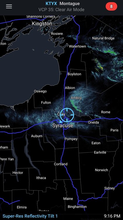
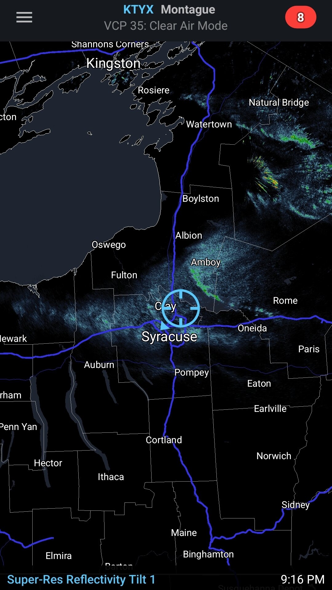
Can 44 degree water offset a bone dry, short northerly fetch? Probably not but it’ll try for a few hours. Already a second scrappy band showing up. We really needed GB tonight.
-
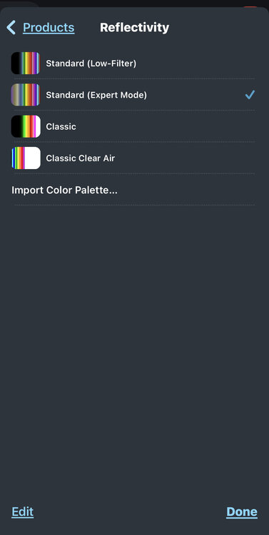
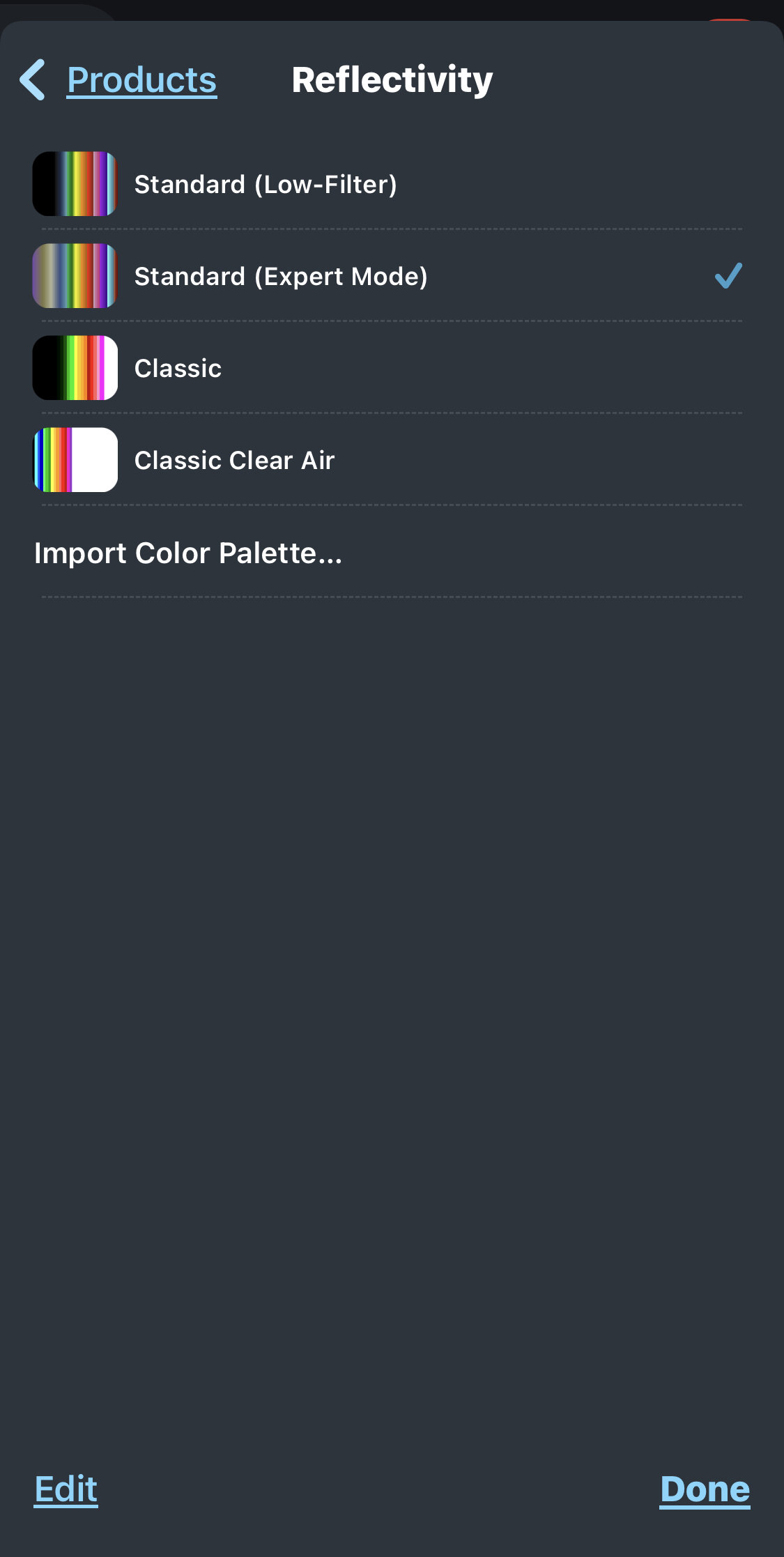
1 hour ago, sferic said:
Here is my RadarScope Pro settings, seems same as yours but image is not
What am I doing wrong?
Thanks !
Hey! I figured it out. Go under settings, then color palette at the bottom, then choose reflectivity, then choose standard (expert mode)
-
4
-
-
I picked up 3 inches in about an hour so the forecast for my backyard verified.
-
2
-
-
That video fails to capture how blinding it really was. But that was the best I got.
Widespread Snow Potential January 16th to January 18th
in Upstate New York/Pennsylvania
Posted
I’ve never seen Toronto get crushed so if it’s going to somewhat miss me I’d love to see them score a big one. It’s takes a really wild setup for that to happen with a huge return interval.