

DeltaT13
-
Posts
3,006 -
Joined
-
Last visited
Content Type
Profiles
Blogs
Forums
American Weather
Media Demo
Store
Gallery
Posts posted by DeltaT13
-
-
21 minutes ago, lakeeffectkid383 said:
Has anyone else ever seen a storm sliding through PA heading to the coast while still seeing a SW flow lake effect band? I can’t recall ever seeing one.
Completely anomalous and fooled me. I had it all wrong. I still don’t understand where the southwest wind came from. Weird wild stuff.
-
 3
3
-
-
I’m back in the Roc, 200.2 miles today. It was certainly interesting and the second half of the day salvaged things. North side of Buffalo got hit pretty good. Not a blockbuster day but no regrets. Probably the deepest and heaviest snow I’ll be in this year.
-
3
-
-
4 minutes ago, Thinksnow18 said:
Odd the heavy returns are right over and yet it’s light snow…
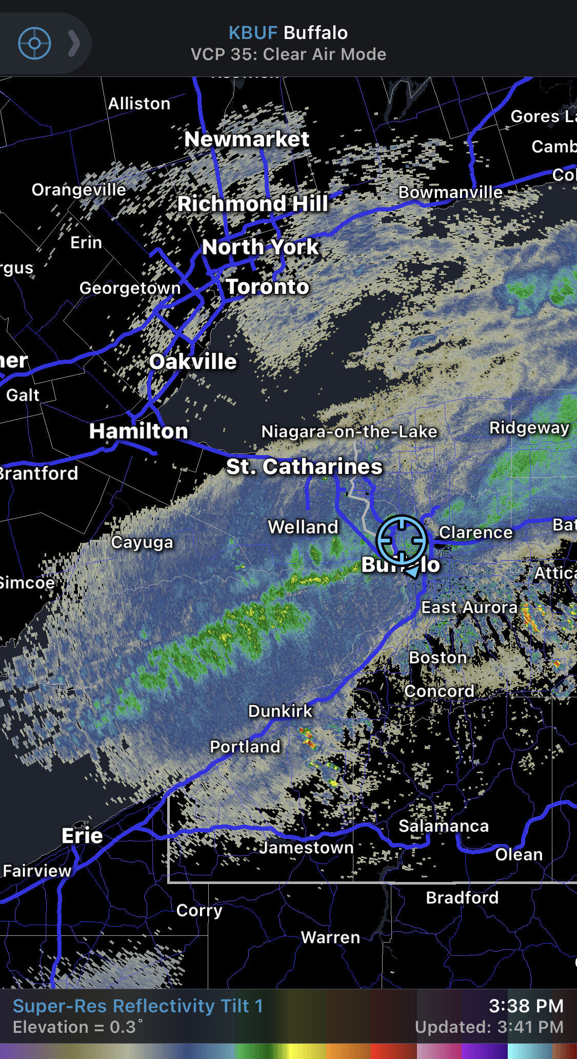
Lot of graupel at times. Might explain the higher returns. It’s pounding pretty good though.
-
1
-
-
North side of Buffalo has a lot of snow! All these tiny back streets are completely clogged with snow. These are the fun ones to blast around on. I’m sitting in a nice position now waiting for that new strong band to get here.

-
6
-
-
11 minutes ago, BuffaloWeather said:
Yeah we should meet up before you head back!
Let me know when you’re on the move.
-
1
-
-
Just now, rochesterdave said:
They could easily go around it. Have them take 86 to 390 N. Don’t have them drive thru Buffalo. That would be insane
For some of us us would awesome! But I agree just take the above mentioned route and they’ll have no issues aside from a million potholes on 86.
-
1
-
 1
1
-
-
3 minutes ago, BuffaloWeather said:
Yeah you can see that moisture coming off of Huron. That band is going to be rocking tonight, likely stronger than it was this morning.
Maybe we’ll cross paths as I’m heading back and you’re heading out?
-
1
-
-
6 minutes ago, Thinksnow18 said:
You can see the band re-organizing over the eastern end. Expecting heavy snow in the next 30 minutes to an hour
Yeah I’m anchored down in Tonawanda/Kenmore for now after cruising up to the falls. Upstream radars showing synoptic moisture coming in and the band appears to show some signs of reorganizing. Hopefully I’ll get some action on my way outta here around 4-5.
-
 1
1
-
-
5 minutes ago, BuffaloWeather said:
As long as I can chase it I don't really care where it falls. I'll be on cloud 9 later today. But being stuck at work while a band is producing 3-4" per is 20 min north, yes its brutal.

No way you could have taken the day off or at least a half day?
-
I tughill Matt’d the shit out of this band. Meeting up with a friend for lunch to salvage the afternoon lol.
-
5
-
-
Heading north on transit enroute to my old stomping grounds in NT. It’s pounding!
-
3
-
-
1 minute ago, TugHillMatt said:
Oh! Let me tag along! The Buffalo crew will LOVE that.......................................
You would part that band like Moses at the Red Sea
-
4
-
-
7 minutes ago, lakeeffectkid383 said:
You may want to set up in Tonawanda by the time you get here lol. That thing is moving north quick. Wonder if it makes it to IAG?
I’ll be on the move. If It is all falls apart I’ll grab wings at duffs and call it a day. I drive there just for them sometimes anyway. Haha
-
2
-
-
If the bad dies soon it’s my fault because I’m enroute to Buffalo! LFG!
-
2
-
2
-
-
Boy I really blew it. Son of a bitch.
-
2
-
 1
1
-
-
What’s odd is that winds odd Huron look westerly. And winds by Cleveland look westerly or even WNW, but maybe those are higher clouds?? Surprised we are getting such a solid SW flow to be honest. Lake Erie must be modifying these winds a bit. Still wouldn’t be surprised to things drop a little south over the next couple of hours
-
Of course I’m having some regrets. A broad daylight chase in downtown would have been pretty amazing

-
14 minutes ago, lakeeffectkid383 said:
I truly don’t understand how we’re going to get lake effect to form with these winds tonight. It’s absolutely unreal out. I’m having gust shake my house worse then the high wind warnings we had a few weeks ago, it’s fricken insane here right now. I bet we’re gusting close to 60mph if not over. I don’t understand how there’s not a high wind warning let alone an advisory.
My kind of lake effect!
-
3
-
-
1 hour ago, Geez150 said:
I grew up in Batavia and still work there. IMO Batavia doesn't do that well for LE. In most cases Wyoming County could say get 12 inches, South Western Genesee County may be at 6-8 and Batavia would be at 4 inches
That’s true but Batavia has the ability to get 18-24 inch totals in the most perfect setups, which some people might not expect.
Wyoming county was always one of the best locations during the good years. Elevation helps them a lot.
-
2
-
-
9 minutes ago, Syrmax said:
Build the Dome! LOL.
Don’t encourage this. Just..no.
-
3
-
-
Agree the weather is a concern but thankfully the jets are a mentally blown out team by this point in another meaningless season. I don’t think they’ll have much fight left in them, especially on the road.
-
4
-
-
9 minutes ago, TugHillMatt said:
Does anyone know what the actual average snowfall is for Batavia? It seems like they get lake effect more often than one would think. I have found somewhere around 80 inches for an average.
They’re in an interesting spot where some years they get crushed by both Erie in the SW events and also double and triple lake connections from Ontario huron and even superior (those super narrow bands that lock in overnight sometimes). But those are rare enough years that they probably don’t change the average. I imagine it’s around 80 overall though.
-
3
-
 2
2
-
-
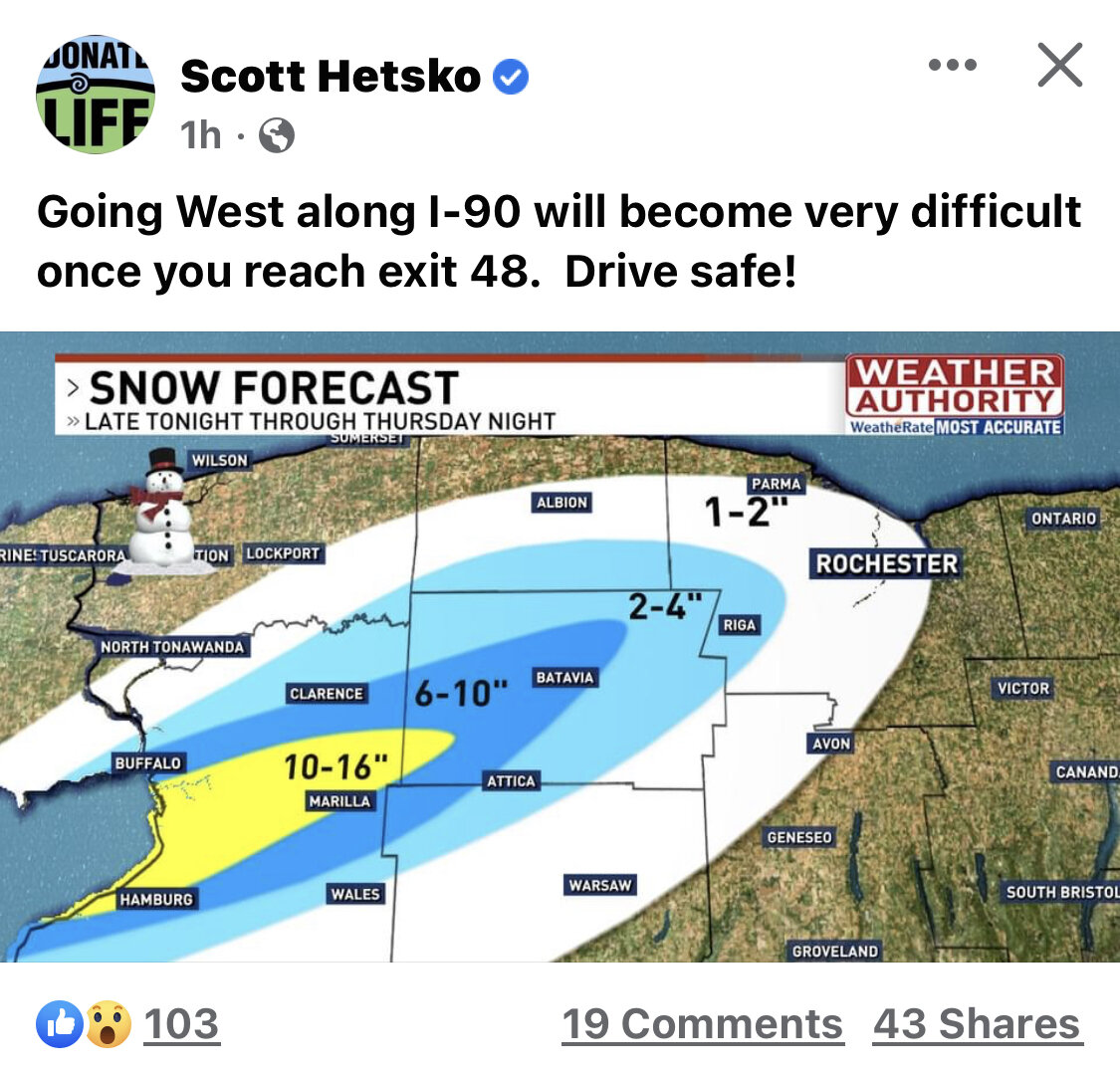
Scotty hesko hedging south quite a bit. But he doesn’t have a lot of skin in this one anyway, haha

-
7 minutes ago, BuffaloWeather said:
I don't think I'm going to sleep much tonight. @DeltaT13 you chasing?
95 percent no. If I woke up and places had 18 inches already and 3 inch an hour rates (somehow, magically) I would probably call a crazy audible and head out. But honestly, this is still a moderate event in my opinion with a much higher chance of coming in lower than higher.
But if I lived in Hamburg you bet your ass Id be out there for a little while tonight! and probably all day tomorrow. For me to chase Buffalo it’s a four hour minimum time investment and a lot of in between travel…..and that only gets me about 90 minutes in the fun stuff! I’d rather go out for 6-8 hours.-
3
-
Upstate/Eastern New York- Jan 5-7 Lake Effect Snow Event
in Upstate New York/Pennsylvania
Posted
I mean I was saying from day one this whole event seemed centered around a giant Great Lakes induced thermal trough, however I didn’t really believe it would be this strong or actually pan out.