DeltaT13
-
Posts
3,006 -
Joined
-
Last visited
Content Type
Profiles
Blogs
Forums
American Weather
Media Demo
Store
Gallery
Everything posted by DeltaT13
-
 Ok well now that I’m in the red stuff it’s the weirdest mix of enormous flakes and sleet. Much easier to drive in but I should probably go back north and get into the snow.
 -
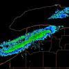
This has to be some of the heaviest snow I’ve ever been in. Ever. Its very hard to drive but also incredible

-
Most of the high res models showed it filling in quickly.
-
Upstate NY Banter and General Discussion..
DeltaT13 replied to wolfie09's topic in Upstate New York/Pennsylvania
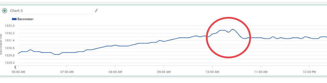
That graph was from my Davis unit. But you could probably download the tempest data and find it. -
Widespread Snow Potential January 16th to January 18th
DeltaT13 replied to sferic's topic in Upstate New York/Pennsylvania
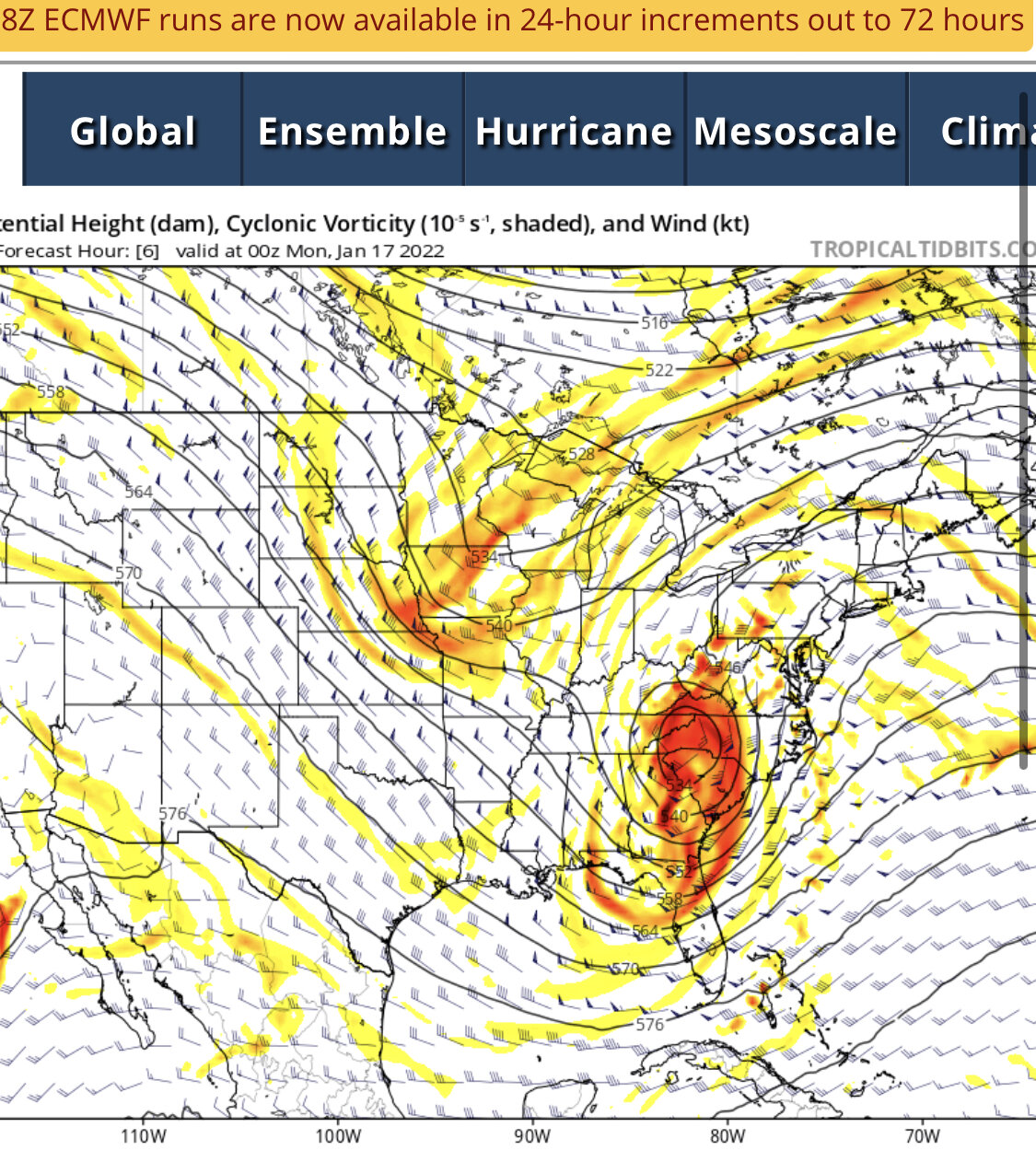
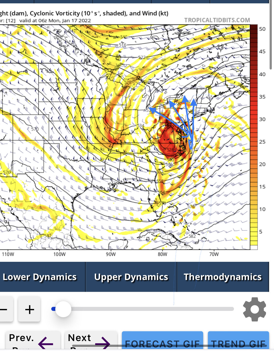
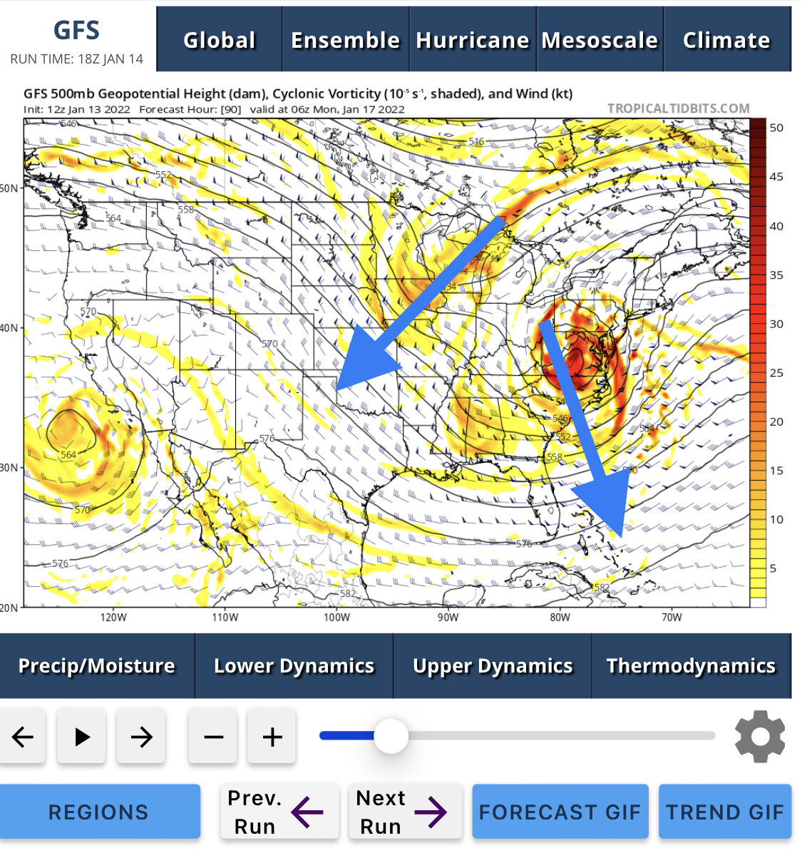
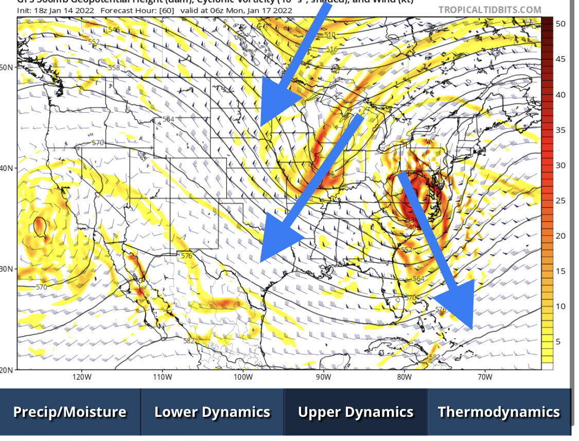
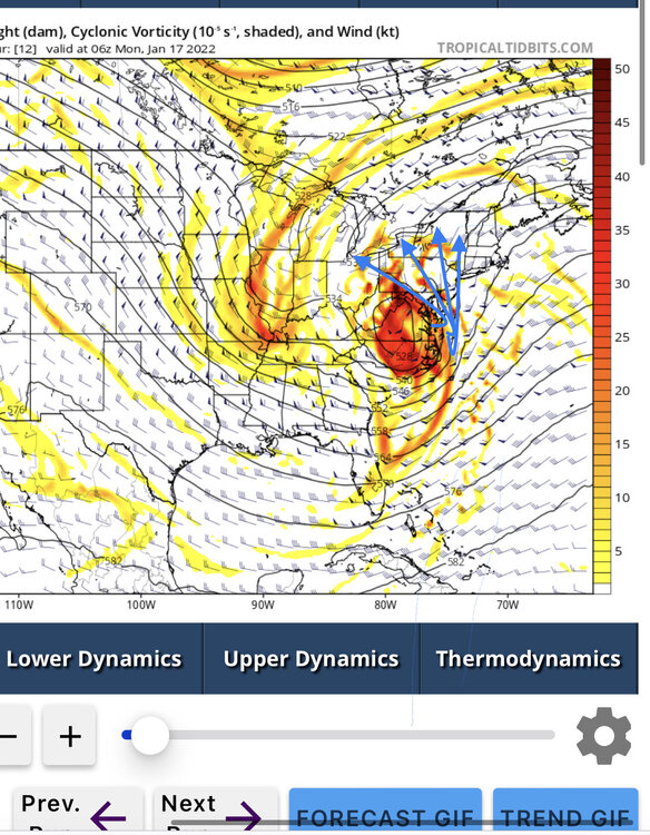
Looking at these 500mb charts, you can see that the two waves finally begin merging right between 7pm and 1am. Look at how diffluent the upper levels are over central and western Pa in the second frame! That drives a ton of surface based upward vertical motion and the surface low pressure surges NW. Not good for anyone east of the Genny. Going to be some incredible rates for those who stay all snow though.
-
Widespread Snow Potential January 16th to January 18th
DeltaT13 replied to sferic's topic in Upstate New York/Pennsylvania
You can see layers of sleet moving through that area with the correlation coefficient
-
Widespread Snow Potential January 16th to January 18th
DeltaT13 replied to sferic's topic in Upstate New York/Pennsylvania
Less amped might mean further East and less mid level warming. We take? -
Widespread Snow Potential January 16th to January 18th
DeltaT13 replied to sferic's topic in Upstate New York/Pennsylvania
1am to 7am looks to be our peak. This will be a long night and a sleepy Monday but that’s how she rolls. If there wasn’t football on I’d be sleeping now. -
Snowboard is cleared. About 1 inch on the ground to start things off. Snow is entering the southern tier. Very excited for tonight.
-
Widespread Snow Potential January 16th to January 18th
DeltaT13 replied to sferic's topic in Upstate New York/Pennsylvania
He’s cross calibrating it to the Rochester airports ruler. It’s a tricky process. -
Upstate NY Banter and General Discussion..
DeltaT13 replied to wolfie09's topic in Upstate New York/Pennsylvania
10 hours and 7500 miles later, my backyard weather station recorded the compression wave from the Hunga Tonga volcano eruption. Pretty awesome.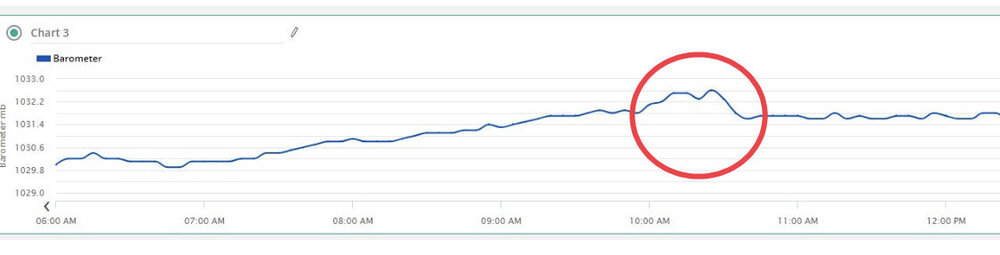
-
Widespread Snow Potential January 16th to January 18th
DeltaT13 replied to sferic's topic in Upstate New York/Pennsylvania
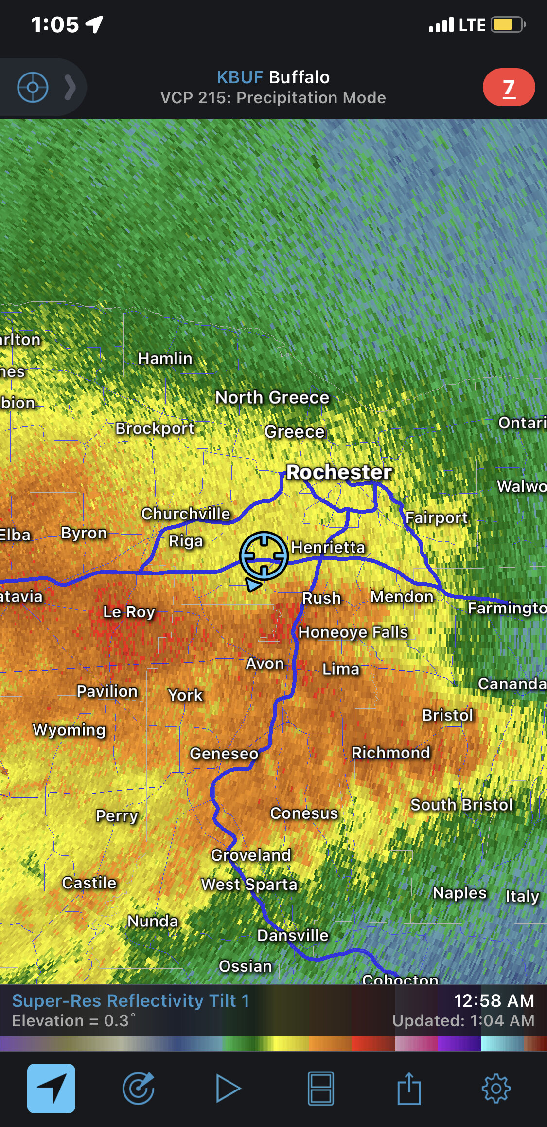
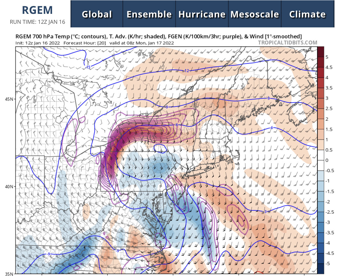
Am I really going to chase this thing at 3am? Seems like it could actually be worth it with crazy rates for a couple hours. Look at the forcing on the RGEM
-
Widespread Snow Potential January 16th to January 18th
DeltaT13 replied to sferic's topic in Upstate New York/Pennsylvania
It’s definitely on my mind but I think we get a 50 mile eastward shift during the final run up the coast. Also im hoping any warm layer is fleeting as it’s wraps into the backside of this. Genny valley is it the battle zone. -
Widespread Snow Potential January 16th to January 18th
DeltaT13 replied to sferic's topic in Upstate New York/Pennsylvania
Yeah I feel like I’m in a perfect position here in KROC Even the tiniest jog East puts us squarely in the crosshairs. -
Widespread Snow Potential January 16th to January 18th
DeltaT13 replied to sferic's topic in Upstate New York/Pennsylvania
I hope you never get snow again. -
That was a super elevation dependent storm if I’m remember it correctly. Had to be over 2000 feet for any snow.
-
I have no idea what you’re thinking of but we didn’t even get an inch in April of 2005
-
Widespread Snow Potential January 16th to January 18th
DeltaT13 replied to sferic's topic in Upstate New York/Pennsylvania
But look at how the isobars are actually broader and more spread out. The placement of little L isn’t all that critical compared to how the overall pressure gradient is worse for wny. -
BUF: 13 ROC: 14 (not including late lake effect) SYR: 8 BGM: 4
-
Widespread Snow Potential January 16th to January 18th
DeltaT13 replied to sferic's topic in Upstate New York/Pennsylvania
I can think of 2 that just barely fit that criteria in the last 4 years. But yeah, not many big hits in recent memory. This would be nice. -
Widespread Snow Potential January 16th to January 18th
DeltaT13 replied to sferic's topic in Upstate New York/Pennsylvania
This storm keeps getting deeper so perhaps dynamic cooling is now coming into play on the western side? -
Upstate NY Banter and General Discussion..
DeltaT13 replied to wolfie09's topic in Upstate New York/Pennsylvania
There will be hundreds of amazing gifs and loops in the coming days. I’ve already seen dozens of them on Twitter. What an incredible explosion. I saw peoples weather stations in Australia over 3000km picked up the compression wave on their barometers. -
Widespread Snow Potential January 16th to January 18th
DeltaT13 replied to sferic's topic in Upstate New York/Pennsylvania
Just remember the smallest grid spacing is the highest resolution. -
Widespread Snow Potential January 16th to January 18th
DeltaT13 replied to sferic's topic in Upstate New York/Pennsylvania
I’ve missed a few pages here so maybe someone mentioned this but I noticed something interesting tonight. A mere 36 hours ago this looked like a double phase with that nice little secondary kicker. By tonight there appears to be another obvious shortwave just upstream of the first kicker which seems to be creating a deeper and more negatively tilted phase. That is likely what is moving everything so far west.