Typhoon Tip
-
Posts
44,621 -
Joined
-
Last visited
Content Type
Profiles
Blogs
Forums
American Weather
Media Demo
Store
Gallery
Everything posted by Typhoon Tip
-
Significant Severe Weather Event Possible Thursday, August 27, 2020
Typhoon Tip replied to weatherwiz's topic in New England
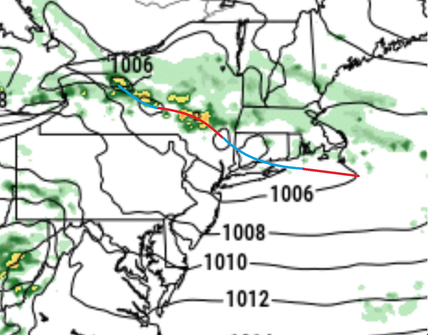
Nah...that doesn't mean the warm front is through there... Side's WPC doesn't agree - -
Significant Severe Weather Event Possible Thursday, August 27, 2020
Typhoon Tip replied to weatherwiz's topic in New England
yeah...and in the defense of the world that exists outside my skull I do tend to come off heavy handed with principles of Met and that probably rubs folks the wrong way ... heh, gee ..ya think ? anyway if the sun comes out and can diabatically heat; that can aid in warm frontal leaps ... right on! However, part of that successful leaping means the DPs actually have to come with it. Without them, it's really just a lucky sunny interval in an otherwise cold butt plugged typical New England stew - which frankly, I'm inclined to think that's how this results... Also in that as we type, that line is plugging SE and will prooobaby ( I'm guessing ) denature the atmosphere to a swath of low clouds afterward. I can't wait until tomorrow... The NAM has 30 to 40% ceiling level RH over the region at 8am ...with offshore flow at 850s supporting about 83 F ... totally different day -
Significant Severe Weather Event Possible Thursday, August 27, 2020
Typhoon Tip replied to weatherwiz's topic in New England
Not sure that matters... Lot of posting about the sun. Okay, but it's not likely to be enough. This cool air mass is a thick anomaly... it needs two, June 21 sun disks in the sky to overcome lol -
Significant Severe Weather Event Possible Thursday, August 27, 2020
Typhoon Tip replied to weatherwiz's topic in New England
The present linear complex pressing quickly SE through upstate NY should put the k-bosh on this for good... It's got some pricey DBZ returns along the axis but nothing triggering warnings ... It clearly also is terminating into an overrunning synoptic plug with crumbled elevated convection kernels to offer pulses of heavier rain in side a light to moderate for a couple of hours. But I'm not even sure the western end of the line outside that shield is really in a warm sector... Anyway, it should cool the BL further and that's the ball-game -
Significant Severe Weather Event Possible Thursday, August 27, 2020
Typhoon Tip replied to weatherwiz's topic in New England
lol, you may be okay ...I added a sentence to that - -
Significant Severe Weather Event Possible Thursday, August 27, 2020
Typhoon Tip replied to weatherwiz's topic in New England
I would put the 850 mb warm boundary inside the gradient - because the boundary is not straight up and down ...it is sloped, such that that it terminates/escapes skyward above the respective sigma levels in the x-coordinate ...so, it is deeper over CT and entry into the boundary interface above that level over S Nh ...so the front is really bifurcating this image an angle - although ...wait...is that doing the depth of the column or is that an just the 850 slice... I may not be right - depends on the product orientation -
Significant Severe Weather Event Possible Thursday, August 27, 2020
Typhoon Tip replied to weatherwiz's topic in New England
Off -topic but this whole cold banking into Maine and SE Ontario around the SW arc of that seasonal anomaly whirling around up there, also indirectly conducting SPC's failure like a great maestro of a symphony called poor allocation of technological wherewithal ( heh ), it is all happening because of a faster than normal ambient wind energy in the hemispheric scope and scales. There's all kinds of mirror feedbacks popping up all over the planet like that. In this case the unusual ongoing subtle but real HC expansion is triggering lingered higher than normal jet velocities that have empirically been observed all over the NH during winters, carried over in smaller proportions but non-negligible during summer. Wave mechanics at super-synoptic scales then means that R-waves didn't get quite as lost in entropy as they normally would. One should simply not see this on a weather chart in the first week of September, when looking at 1800 through about 1982 reanalysis as one's template mean: I mean, they don't disappear altogether; we're talking about "approaching"? But that up there represents vast, deep constructive R-wave fed-back anomalies that are both x-y and z coordinate not supposed to happen when compared to the previous data mean suggestion - clearly something has changed. And, that is an assertion based upon persistence, too. This is a snapshot that is increasingly more common really since the super Nino of 1998 ended, albeit more noticeable with increasing frequency spanning the last 10 years. It's important to note because we are transition from the old guard to the new behavior norm with the GW stuff and many middle aged weather folks and enthusiast are defaulted to being the unfortunate inheritors of different spectrum of experiences, from 1960 through 1998, as as their guide. Anyway, this vortex up there, I watched it closely evolve since 10 days ago in the EPS and the operational version... as well as the GFS cluster. It really didn't set up like a typical synoptic progression. It's really like the atmosphere spontaneiously "gapped open" and then that space was defaulted into a low pressure node - it really appeared more so to be harmonic planetary vortex/R-wave ... ( pseudo " rogue" in the atmosphere ) that created this thing up there, more so than a cyclone maturing in the flow in the standard sense of the "Norwegian Model Low" NML. This is a result of a global warming as a wild op ed assertion that is guaranteed to role other Met eyes. But, you cannot drive 70 to 90 kt sustatain jet mechanics over the arc of the N. Pac into western Canada, without wave mechanics becoming more than neutralized at any time of year. Season is irrelevant ...it's about kinematics at that point... This is why we have been entertained by so many unusual CAA events in Octobers ... deep enough to send 'packing pellet' snow in the air, if not unusually early wet snow from synoptic events since this tendency of HC expansion began in the late 1990s and has advanced since ... intruding upon the lower Ferrel Cells latitude ... and the problem therein is that the boudnary between the HC and FC is amorphous...It's not like you put a ruler down on the 570 DM contour and assume away. The velocity is skewing the season end points. It's inducing 'fold over' trough nodes like this in autumns and in springs ( they are somewhat analog to hemispheric scaled Kelvin-Hemholtz waves). This needs a definitive empirical data fetch...but, I personally observed perhaps 5 autumn and/or springs with snow or snow-supporting atmospheres between 1970 and 1998 ... I have witness this 15 times since 2000, while all this HC and gradient saturation speed anomaly stuff become ever more evidence.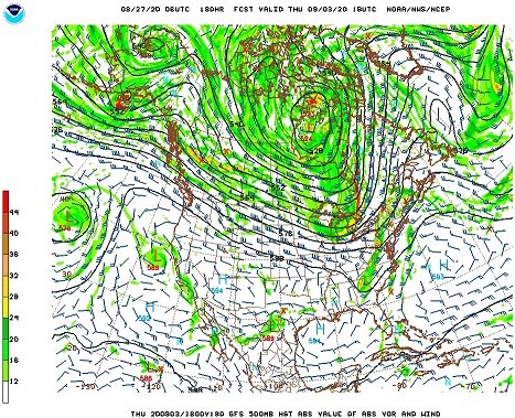
-
Significant Severe Weather Event Possible Thursday, August 27, 2020
Typhoon Tip replied to weatherwiz's topic in New England
Not to be a douche and you don't know me ...I don't think .. but, I don't believe that front actually can move NE of it's current position looking at this at a broad conceptual approach to this situation. ..as in fluid mechanically it can't. Then, after that notion... one has to consider New England's climatology with BD-pinned fronts, which is just a dense clay of other geographical feed-back no-no's - eesh The flow is paralleling the boundary; it's like all of the analytic Meteorological brain trust has gone mad. When do warm fronts penetrate through an abrasion flow? That is like ..physically impossible. This situation seems(ed) dead to me when I saw that yesterday in the models..W-NW flow at mid levels. What is SPC using? Now, granted ...that shuts off any hope of "SB" in the SB CAPE.. but elevated... mmm maybe. But they are not talking about "elevated" per se convection in the morning write up... Which, by the way folks - there's currently a cut-off vortex near the 50N/50W position slopping cat -paws over eastern Ontario above the 50th parallel, and that feature is pinned in position. That backlogs the W-NW or arguably more NW flow at mid levels here, which pins the warm front there... end of discussion. Now, this was all modeled ..I am actually interested in how SPC came by their enhanced geographic layout - because looking at these very real and reasonably well modeled synoptic circumstances, I don't see how they come by their risk assessed region like that. The only way I see Enhanced clear to Springfield Massachusetts ... is if clearing opens up sun almost entirely ( 90% open ceilings/cloud extraction) and the atmosphere gets diabatically forced by the sun... but, the sun is now mid April in intensity ... ( for perspective ) ...It's not May-July out there so even so, its harder for the sun to do that at our latitude and depth of atmosphere east of Berkshires .. Moot anyway looking at sat trends... However... ugh, I am - reluctantly - interested in if there is an elevate hail risk where any stronger convection that is feeding purely off the 850 upglide parcel lift on the flop side of the front, and is paralleling it racing SE... yeah...maybe. But, we may as well not even call this a warm front. .. There is a 101 synoptic term that is out there available for this sort of phenomenon and it is called a "stationary" front. And, with the mid level flow abraded(ing) SE that like it is ... sawing off any warm intrusion attempting to mix down... that leaves only one possibility - the models are/were wrong ( but so far nearing mid morning the pinned front is well handled) I guess if the vortex NW of NS/NF weakens during the day, and the mid level flow veers slightly... and the stationary boundary does actually "warm" for a period of time...it might intrude into CT ..but that's not modeled to do that... I don't think ? -
Significant Severe Weather Event Possible Thursday, August 27, 2020
Typhoon Tip replied to weatherwiz's topic in New England
Don't feel so bad ... there are two distinct chances for "responsible lust for destruction" on the 00z Euro beyond this joke, each far more interesting than this one ever should have been allowed to be... -
Significant Severe Weather Event Possible Thursday, August 27, 2020
Typhoon Tip replied to weatherwiz's topic in New England
Nope ... -
Significant Severe Weather Event Possible Thursday, August 27, 2020
Typhoon Tip replied to weatherwiz's topic in New England
Steve is like the heckler in the audience explaining to everyone why tongue-in cheek/sardonic wit isn't funny - -
Significant Severe Weather Event Possible Thursday, August 27, 2020
Typhoon Tip replied to weatherwiz's topic in New England
agreed... -
Significant Severe Weather Event Possible Thursday, August 27, 2020
Typhoon Tip replied to weatherwiz's topic in New England
Well.. than I hope my next GF's name is 'stratosphere' -
Significant Severe Weather Event Possible Thursday, August 27, 2020
Typhoon Tip replied to weatherwiz's topic in New England
Hmm..several observations re that bold text. 1 .. For anyone of this particular pre-occupation and engagement the words "hot" and "girlfriend" being used in the same turn of phrase - is akin to the vin diagram needed to decode one of my synoptic overviews prior to a pattern change ... 2 .. And, that may be bargaining in itself, as though leveling that suggestion at us gives hope those two facets could ever be collocated in time ... ? 2 .. why have a 'hot' girlfriend? ...beyond the carnal desire for one, that is... It's far more likely and healthy, both physically and spiritually... to find a committed woman/man ( depending on how one identifies themself) in the aggregate population... One's that are more homely, vaguely tolerable to look at, and can even laugh... they stay compared to glib individuals that have been enabled by looks and therefore never really learned humility for their journeys to date. That's why those are "ex" and "hot" in the same turn of phrase - that was the problem in the first place. Those types often have oddly working internal appraisal compasses - if at all - pointing more inwards, and thus don't so readily recognize or appreciate true beauty in another individual .. Oh they say they do, if they've learned societal conventions and stop short of allowing their placated existence from turning them into sociopaths.. But, you're likely to fare better odds with a 7/10 lady/dude with her/his head screwed on straight any day over 9.2 with her/his head up some kind of Princess/Prince complexed lagging developmental ass ..any day. -
Significant Severe Weather Event Possible Thursday, August 27, 2020
Typhoon Tip replied to weatherwiz's topic in New England
See I thought/was under the false impression the 00z Euro had the boundary N of this... If this is the boundary's mean position 12z ... there is nothing happening and this thread should be evaporated, unceremoniously as though a personal attack on convection enthusiasts to really nail the p.o.s.ness of this pattern home.. LOL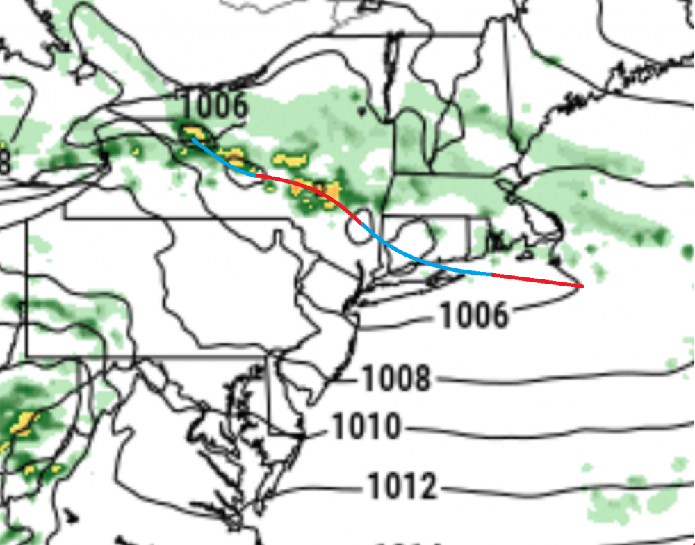
-
Significant Severe Weather Event Possible Thursday, August 27, 2020
Typhoon Tip replied to weatherwiz's topic in New England
Ladies and gentlemen... this is what we in Psycho-babble refer to as "bargaining" - ...it's a self-soothing tactical alternative in plausibility that is typically created to avoid having to face an inevitable painful reality... Using this as a predictive model, the subject will like experience a 'melt-down' as the next phase along the total acceptance of butt-bang arc to full recovery - -
Significant Severe Weather Event Possible Thursday, August 27, 2020
Typhoon Tip replied to weatherwiz's topic in New England
It's also possible ... yeah, that the NAM is over doing it with that. I have actually seen the NAM be too aggressive with BD too - it's just not typically the case. Most often, even the higher resolution runs will end up needing to correct SW ... So, if it is ideal 72 F with pancake feathery CU Golf weather where once stood a mighty enhanced wording...while there is far distant anvil wall on the absolute S/SW horizons during baseball hail at Trenton NJ don't be surprised. -
Significant Severe Weather Event Possible Thursday, August 27, 2020
Typhoon Tip replied to weatherwiz's topic in New England
that's more like it! When the universe ages to it's termination and ceases to exist... SPC will still be trying to place warm fronts too far NE into this sort of synoptic set up - -
Significant Severe Weather Event Possible Thursday, August 27, 2020
Typhoon Tip replied to weatherwiz's topic in New England
Now watch...just because I mentioned that stuff about the geo-morphology and forcing of near earth surface synoptic weather phenomenon ...limiting warm frontal intrusion ...the 12z NAM will go ahead punch the f'er to Grey Maine... ha -
Significant Severe Weather Event Possible Thursday, August 27, 2020
Typhoon Tip replied to weatherwiz's topic in New England
in a bushman's vision ...that's why though. This is anomalous air mass for seasonal change... It's not even a preview ( 'shot across the bow') really ...strikes me as a fluke. I like shot across the bow, breaking back air masses to be anchored in a definitive pattern modulation... This is a weird thing that I think is related to another popsicle headache... Anyway, 18 hours later summer tries to surge back, and homage to the idea that it's still there... And that's a problem ...when you have still active moisture draining off foliage and evaporation of soil moisture content in the midwest and Lakes regions .. mixing with tumbling 17+C 850 mb temperatures ready to surge right back in, this unusualness of the severe set up for this time of year...is sort of indicative of this 18 to 24 hour fluke air mass... Correct one way, snap back - It's really difficult up our way too...because our topography/geographical feed backs offer more forcing that stall or even reverse warm fronts. Basically, because the land falls out in elevation from underneath the troposphere when east of NY/VT/NH. Vectors lifting over the western hills/mountains and general higher elevation, sets up a kind of "invisible" counter-vector that rolls the atmosphere and tacks back W-S at lower levels east of said axis... There's a forcing back SW... at all time below 800 or so mb. This is why BDs seem to get pulled back down the coast...it's more than just the mass discontinuity ...That's the start, but that motion of air then gets a kick-back from that tacked vector and then the boundary over achieves... it's why in late April, a common almost fixture of fronts stalled in the area is that fronts align smartly due E until about Albany, then curvilinearly descend SE and wrap around NE and even go back N over the water E of Cape Cod... It's that rolling motion that retarding. It's also why we "tuck" in the winter and enjoy ice storms while PF in N. VT is 52 F at mid slope. -
Significant Severe Weather Event Possible Thursday, August 27, 2020
Typhoon Tip replied to weatherwiz's topic in New England
And Saturday looks really bad to me on the 00z Euro... In fact, the behavior of the pressure pattern and QPF matches climo typology for tornadic events over eastern NY the upper MA and interior SNE ... with a pretty clearly define morning straif of elevated convection along a warm front strongly supported by synoptic detailing, giving way to warm sector intrusion to lower VT/NH ... and along the residual warm frontal axis arcing into upstate NY there are very intense convective nodes exploding in the model resolution of what happens next... Those are super cells folks - no question given the W 70-90 kt 500 mb flow running collocated overtop a sun steamed, fresh theta-e transported low level thermal ridge ( 850s 20 C CT over SE Massachusetts!), and heights tending to fall overtop from west to east across the area between 18z and 00z Sunday... The key is.. warm intrusion and fresh falls of BL rains near 12z clears out and this creates a pal of SB CAPE anomaly in the area...if we go back and look at the daily behavior prior to '89, Monson 2010, even ORH '53 ...and the Mohawk Trail MCS June 10 '87 ...these are all fine examples of what to look for and were remarkably similar with dawn rumble rains that peeled away and sun-soared to mid 80s/72 blue-tinted bath water hillsides ... ensuing jet mechanics nosing in mid day from the west... That's Saturday incarnate - I mean Oklahomans might feel jealous looking at these general synoptic parameters. Devil's in the details with convection though ...so, this is just what I've gleaned off Pivotal - there may be distractions I'm not seeing or are unaware therein but ... it's like Thursday and Friday have their intrigue, but Saturday was painted with unique convergence of parameters constructing a convective appeal on a guidance that is very tough to beat at time ranges < 120 hours. I would change the title to three days of potential and just encapsulate the whole saga - -
Significant Severe Weather Event Possible Thursday, August 27, 2020
Typhoon Tip replied to weatherwiz's topic in New England
Ha ha yeah this isn’t the panhandle of Texas from late April to early June when you have 45 straight days of visible crispy super cells rollin under the tropopause -
Significant Severe Weather Event Possible Thursday, August 27, 2020
Typhoon Tip replied to weatherwiz's topic in New England
All three days Thursday through Saturday look troublesome or certainly could turn out that way with that front oscillating in the area ... accentuated helictites long it with unusual thermal gradient for this time of the year either side is intriguing. Seems that EOF1swarm idea had shifted more to Saturday with organized cyclone mechanics in the area but the boundary itself could be active for a couple days before that ...wherever ultimately sets up -
Significant Severe Weather Event Possible Thursday, August 27, 2020
Typhoon Tip replied to weatherwiz's topic in New England
Can't say I disagree with this notification effort thru yesterday's 12z... 00z, not so much in the Euro, but the GFS hangs on a bit... But In the other thread, I mentioned a couple days ago that D5/6 looked like an "EOF1 bomb" potential for the upper MA to NE states... These baser kinematic structures you're honing in on were evidence back then and as of yesterday - by then D3 ... Maybe like a last season 'threat hurrah' as the summer closes the books and we'll see if this new-ish complexion toward seasonal migration that the operational Euro GFS suddenly paint has legs... Could be a rush job - I think the GFS 528 dm double noded height core amid a continental scoped, sub polar vortex over JB is a bit hard to cough down in late August/early Sept... but, I also covet some personal "science fiction" plausibilities as to why the model is doing that, and it is rooted in evidence spanning the last 6 years... Namely, we've been "continental folding" at transition seasons with unusual proficiency at the books ends of winter. That's John- labeling ...there's no actual identity of that in Meteorological/climate vernacular ...but, I call it that ...it's like super synoptic scaled "Kelvin-Helmholtz" effect. We have velocity surpluses in the mid and upper tropospheric ambience that is tending to kick in very early in transition season, and... lagging unsually long on the way out. The cause is the expanding HC...or in the case of Autumn, the HC expansion as a persistence on-going perpetuated state, is triggering gradient to increase very quickly as the sun's integrate insolation across the hemisphere begins to dim toward the ends of August and particularly...during Sep/Oct ... This increased gradient is directly proportional to the surplus velocity. But why that is important is, the velocity of the jet is "folding" over the top mass of the R-wave fields, and this is increasing/enhancing trough node tendencies earlier in the year of eastern/southern Canada, and also... in May's ... This 'plausibility' is why we have since 2000 experience either synoptic scaled snow chances, or, ... packing pellet virga exploded CU cold waves in Octobers and May some 1/2 if not 2/3rds of the last 20 years worth of transition seasons ...either end. In between? ...DJF/early M .... that HC stuff impinges a whole 'nother issue with raging jet velocities so extreme that it forcing a morphology of precipitation event structures. Anyway, this may seem to have nothing to do with Thursday at this point ...but, it does in the sense that the mechanics are perhaps being exaggerated over what is normal up our way...as these gradient rich events transpire through lingering seasonal warmth and dps... Outside the box thinking a little - In any case, the pattern looks in the 00z run by the Euro to have moved to more a NW flow with some positive shearing ...maybe more whisky line or even MCS-y -
The absolute scalar point at the end wasn't intended for you, per se ... just sayn' The point and supposition ...formulaic en route to a hypothesis I am/was attempting is right there ( enlarged bold ) as a necessity. If it is very warm(cool), we'll talk. Hypothetical/boundary premise: I'm just creating hypothetical numbers to elucidate the point there... If the region outside of the ENSO ...which in a coupled oceanic-atmosphere volume of atmosphere is the entire planet... is already hot... what f'n difference does 1.5 C in SST mean when subtropical waters outside of the spatial domain of the ENSO band itself are already +2 or +3 C ...? It's a tricky argument to settle, no doubt... because that scalar thing does play an evil role in the consideration (ha). Fascinating... But, +3 C at 35 N... does not carry as much energy in the coupled system, as +1.5C anomaly does farther S - why? Because +1.5 C in a 80 F water column has a more energy stored in it than a +3 C in a column of 74 C... This complexity then gets far more grueling a prospect then asking this particular collection of 2020 unprincipled politicians to agree on the flatness of Earth! I'd think I might rather suck on the latter's pistol muzzle over having to solve the other one - Anyway, you get my meaning... so, gradating the force is also a nightmarishly complex secondary and tertiary derivative(s) in, and if/when the scaling of the equations and all that shit.. yeesh! So I just smooth it out conceptually ... The boundary of the HC has expanded too far beyond the ENSO domain ..such that the ball of the ENSO is bouncing around inside and not transferring momentum into the jet/R-wave middle latitudes ...because the lowering gradient once inside the boundary of the HC, is decoupling it's effect. Plausible evidence of this: The pattern of response behavior over recent decades with these NINOs and NINA regimes has changed to be less impacting. It seems neither has been very representative... The last "super NINO" (...which, that is not a distinction in conceit it statistically was that abnormal ) expressed very limited or at worse, manageable impacts around the known global regions. This sort of dimming correlation between occurrence vs impact in the total complexion is - in my mind - likely geophysical in nature ( i.e., more than 'chancy'), from having a warmer expanded HC into the lower middle latitudes. This has expanded the playing field beyond the QB's throwing distance if we want to beat the metaphor to death. If the atmosphere was more akin to 1955, and then we ran a super NINO like 5 clicks ago up underneath that ...? Phew, we'd probably have had hell to pay in enormous geo-physical responses, because gradient is the entire machinery of nature ...and...weather and climate - that's the whole game. I keep harping that...because ( not you but a lot of enthusiasts and others...) see El Nino and their expectation of what that will mean ... becomes too guiding. Has to be qualified ( in a sense). One my know that if A=B there is no A or B ...intellectually say they understand this stuff, but then turn around and their seasonal predictions are hugely instrumentally based upon the ENSO? What - Well...anywho... I toss almost all ENSO based forecast these days and assume if the season correlated, it's probably luck ...because the polar indexes and Asian torque guiding the total pacific in the wave absorption at the super synoptic scales, happened to come into sync and that gave a false impression of causality. ... It's very similar if not down right analogous to the MJO: If the surrounding atmosphere is in constructive wave interference, the MJO looks like it was the entire cause of why the circulation over all took on its construct... but, if the surrounding medium is in destructive interference... we pass through huge Phase 8/1/2 and end up with a Clipper ... So in that sense ...a warmer atmosphere and ballooned HC doesn't give the ENSO chance to even sync