Typhoon Tip
-
Posts
44,244 -
Joined
-
Last visited
Content Type
Profiles
Blogs
Forums
American Weather
Media Demo
Store
Gallery
Everything posted by Typhoon Tip
-
OH yeah ..I know. And it's early. I'm just feelin' a tad sarcastic this morning
-
Whether the patterning resembles or not is 'sides the point, the present results are very homage to the 1980s.
-
Lol, look at this incredible agreement by the 06z GEFs ... what a bomb, huh
-
Saw that. It still left something to be desired but is a good start. From mid way through the 14th to the end of the 18s that entire 3.75 days has troughiness rolling impulses underneath us, with cold and relative +PP situated N. Only one clips us but ... certainly a good table set from this range...
-
Some flurries at the moment this far inland. First I've seen snow this year as a personal achievement ( I was in Va Beach over the holiday so missed )
-
Yeah, I wasn’t too concerned about exact dates. I was being whimsical. I just know that we went through a really really good stretch where pretty much every year seemed to deliver at least winter …maybe it’s just been since 2020 or something I don’t know, but where I am there has not been a good winter since 2015. I don’t really gather much praise around March events unless they’re rivals, or winters that give one sig event. The reason I stopped at 2010 is because 2012 was probably the worst winter that I’ve ever experienced
-
I feel like 1992 thru about 2010 was basically the Patriots Tom Brady era of weather for us... ever since then it's been like every season since he left
-
Dearth of "blizzard" triggers may have something to do with that. haha we'll see -
-
Erstwhile -AO didn't payout on our side of the hemisphere. Happens. I remember back in the hell autumn of 2006. Toward the end of that extraordinary warm run ( after Xmas of course...), the AO tanked. But we stayed warm for a good two weeks. Eurasia got freak cold right away... Eventually the wave# spun around the axis and caught up with the America and we broke cold late in January... At least enough for the Valentines storm that February. Not sure what happened after that cause I start tuning out on winters most years after about the 20th of February. Anyway, -AO may unload unevenly.
-
That year was really weird.. My buddy in FIT ( just N of Rt 2 in those hills) got something like 130" ...I was still in Acton at the time and got something like 70 - which isn't bad... It was above normal but Acton and FIT are like 20 mi tops.
-
Yup, wrote about this last page or the one before, this morning. This is not a-typical of 'big warm up' topography whence during these progressive/fast flow patterns. The "correction vector" is less length of time. Over and over again, over the years of modeling we can observe this. A 6-day warm up ends up 18 to 48 hours of warm sector. This did it exactly like that again.
-
Okay, in deference to the above ... I like reading this from the MJO desk: • The RMM-based MJO signal continues to remain amplified, with the enhanced convective envelope approaching the Maritime Continent. Dynamical models depict continued eastward propagation during the next 2-3 weeks. • The dominance of low-frequency modes (ENSO, IOD) has been declining over the last few weeks, while the MJO has become stronger and more coherent. I also just want to remind - the MJO is not a pattern drive. It's a modulator. It will positively(negatively) interfere with the surrounding super synopsis ... if the latter is receptive(not receptive) to it's forcing. Part of which is the Pacific ENSO aspects ( down stream of the IOD brick wall of head-on collision sudden pattern death!) ... Anyway, this particular MJO "means more" than priors if you ask me, because as they hint ... this projection of it has more a positive interference. I just checked the overnight numerical telecons and the EPO is suddenly collapsed toward neutral between the 12th and 20th. That could be an early nod to physical forcing transmitting down wind of the erstwhile -WPO. Which is actually the lagged correlation between those fields in the total Pacific arc manifold. Short words ... yeah, there's hope approaching the 20th for winter enthusiasts.
-
Lol, .01" west of the Annisquam River Bridge
-
Exactly ... In dailies/practical terms, there's nothing there to be either disappointed with, or happy about. It's really oblivious. Agree, be it MJO ...or a Asian wave break in the flow ...something to impact enough forcing to synergy/constructively interfere. One thing I am noticing is the WPO is ( numerically) negative, despite the EPO flatlined. If an MJO is destined to propagate out of the Marine region and comes into western Pac up underneath, the two could certainly do what we are asking above. If ( and hopefully when) that happens, we see a pattern change from this marching shit above into something more classical. It could do it pretty quickly too - we'll see.
-
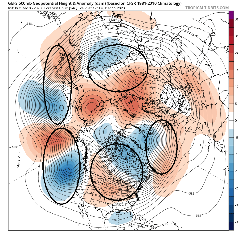
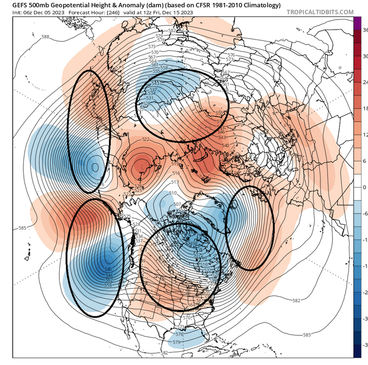
I don't think there's a whole helluva lot of predictive skill right now - more entropy than is even normal model-climate ( for the general reader here). Typically by day 10 in the ensemble means there is a better sense of where the R-wave anchor points are situated, but in this case ... that's a very difficult layout to ascertain. See below... each ovoid is an identifiable L/W ( reasonably consistent among the EPS and GEPS, too), and when putting this in cinema ...they are marching right along. This is a reshuffling hemisphere is what we are looking at. Predictive skill goes out the window. The wave over the continent appears to be more 'standing' in nature, which I argue is an artifact more so of MT forcing and the perennial footprint just perhaps a little more amplified - in other words, it may not be as real as it looks there - speculative. But that Pacific is undulating through -PNA:+PNA:-PNA ...etc, as each of those L/Ws propagates through the region east of the Date Line. How those will periodically transmit signals down stream will vary in just about equal positive and negative values, up and down, ever couple days or so. Resulting, there could and likely will be events materializing that were not there two days ago...then, mysteriously vanish two days in the future, whenever this sort of reshuffle is going on.
-
This is what happens in these progressive patterns. When you see a big warm up spanning 7 to 10 days on the week two+ frames during progressive basal tendencies, the big warm up ends up being a single day to day and half warm sector. That's exactly what the last 10 days have done to the big warm up prior to the 20th. It's compressed the timing. It's impressive for 2 days: Saturday's just calm and balmy, and then Sunday's a windy warm sector. Pretty good 850 mb jet core out ahead of the cold front so that could make embedded convection interesting... but, the 925's don't look very impressive to me so the idea of leanin' trees for hours heh.
-
Ugly 18z GFS run for holiday mood
-
Mm ...not sure about "very" as qualifying adjective in that discussion LOL In my attempt at an unbiased observation there, the Weeklies 30 -day mean looks like a modestly amplified variant of the perennial base-line pattern across the continent. I won't go into much further than that. Y'all have more experience working with that particular part of the Euro product suite - I'm just saying what that looks like. It's only modestly more amplified than the perennial canvas.
-
Oh yeah ... Okay, that leads me to wonder if this grows in future guidance. I think those events in the field are too amplified given the 'super synopsis' . How much so remains to be seen, but if that flattens out some we may end up with more BD trouble.
-
Recommend the '60 Minutes' segment on Quantum Computing. Unless one is intellectually challenged or for some other reason is just too impaired in that regard ... the content will dazzle and inspire the imagination in ways that prior to had zero plausibility. The practical application of QC is projected for ~ 2030. For a lot of reasons. ...where does one even begin ... the trope 'this is going to change everything' is uh ... VERY apropos. Put it this way ... transistor theory is the bases of all artificial computing, from ENIAC (1945) to the World Powerful Supercomputer (2022), even the latter has a limitation. The limitation is in fact a dead leg stop. It cannot penetrate the Uncertainty Principle. The entire manifold of computer technology, ultimately cannot do that. The gross way to describe how 'quantum processing' works is that the electrons themselves are encoded with the information. There is an immense manifold of mathematics between that aspect and the following statement, but, as Dr. Michio Kaku (among the pantheon of interviewees) stated, "... All possibilities in a given system are determined SIMULTANEOUSLY" What one has to understand to really begin to grapple a hold of the significance of that is, a vast number of problems in nature cannot be solved by calculating the linear dependency of A--> B --> C ... N terms. Those problems will be solvable. AND, ...here's the part that really blows the mind. Not only will they be solvable, but they will be solvable ... very close to instantly. It's hard to really get one's head or even imagination around what the means. There are problems in DNA science that cannot be solved in the ABCN method. They are quantum uncertainty dependent. This is true also in ... duh duh dunnnn weather forecasting The positive feed-back ( in the sense of "Moore's Law" for example) on research in general is incalculable. They ( meaning humanity) will be able to explore every field of physics boundlessly beyond where present day limitations hold them back - and believe me, there is stuff out there that's already esoteric and lesser known, and exotic, already. Cutting edge stuff left on the research bench because it's all rendered just as quickly outmoded. I don't personally think humanity will survive it. I think it's a Fermian loop-hold that cannot be escaped from when factoring in human nature; and the rest of the cosmos' linear propagation will continue on down the river of time, leaving us behind. But we'll see... Dr Kaku also ended the segment with the daunting prose to the affect of, 'Whom ever controls this first, will be the ultimate global economic power.' I dunno. I don't think 'IQ OF God' technology was ever intended to be incentivized that way
-
Is that real wedging or just the model's attempt at resolving mountain perturbation
-
Yeaaah, in his/her defense ... it may be a 'too early in the year' to pay dividends type of thing. I was serious when I asked, 'what am I missing here' because if there were/is some qualifying statement like ^ ( for example) then okay - But out of hand that looks like a strong penetration through typical cold correlation over the Americas. The seasonality aspect is dubious though - if the pattern is receptive to the MJO than it's receptive - the two will be in a constructive interference. Merely seeing a wave strength on the RMM is an insufficient basis alone. We did clock one insignificant snow event over the t-giggedy holiday week, and this gig last night up N. ...etc... There was also a -EPO burst about 10 days or more ago, which may have ultimately sourced the cold load for some of the chillier days. Let's remind, Novie went down as a neggie month.
-
It just did ... what am I missing here?
-
evidence here of an STJ https://www.tropicaltidbits.com/sat/satlooper.php?region=atlpac-wide&product=truecolor
-
Winter '23-'24 Will Be A Lesson In Relativity
Typhoon Tip replied to 40/70 Benchmark's topic in New England
Dude... this looks like a crude attempt at a STJ https://www.tropicaltidbits.com/sat/satlooper.php?region=atlpac-wide&product=truecolor ..time sensitive I don't particularly like recent trends with the bulk ensemble means, from either the EPS of GEFs through the 20th. Rumor has it the deep field astronomy has the cosmos expanding into cold fantasies - maybe, no opinion for now.