

stormtracker
-
Posts
64,402 -
Joined
-
Last visited
Content Type
Profiles
Blogs
Forums
American Weather
Media Demo
Store
Gallery
Everything posted by stormtracker
-

2024 Valentines Day Who the Hell Knows - Comeback Thread
stormtracker replied to DDweatherman's topic in Mid Atlantic
Shame it's the Nam. Pretty interesting look at 84. Hopefully we get some luck in an hour or so -
2024 Valentines Day Who the Hell Knows - Comeback Thread
stormtracker replied to DDweatherman's topic in Mid Atlantic
The NAM is a pretty decent run for us at 84... Freezing line at the surface collapses into just NW of the fall line -
2024 Valentines Day Who the Hell Knows - Comeback Thread
stormtracker replied to DDweatherman's topic in Mid Atlantic
0 line south of us with moderate precip over top. Freezing line not all that far off.. just east of hagerstown then up to the M/D line -
2024 Valentines Day Who the Hell Knows - Comeback Thread
stormtracker replied to DDweatherman's topic in Mid Atlantic
Slightly cooler...heavy precip more focused south of us vs 118z -
2024 Valentines Day Who the Hell Knows - Comeback Thread
stormtracker replied to DDweatherman's topic in Mid Atlantic
For those that care about the NAM...it's a bit souther than 18z...precip field looks more pressed than 18z so far -
2024 Valentines Day Who the Hell Knows - Comeback Thread
stormtracker replied to DDweatherman's topic in Mid Atlantic
I don't. But yeah, I zoomed out and it's def south of 12z -
2024 Valentines Day Who the Hell Knows - Comeback Thread
stormtracker replied to DDweatherman's topic in Mid Atlantic
90: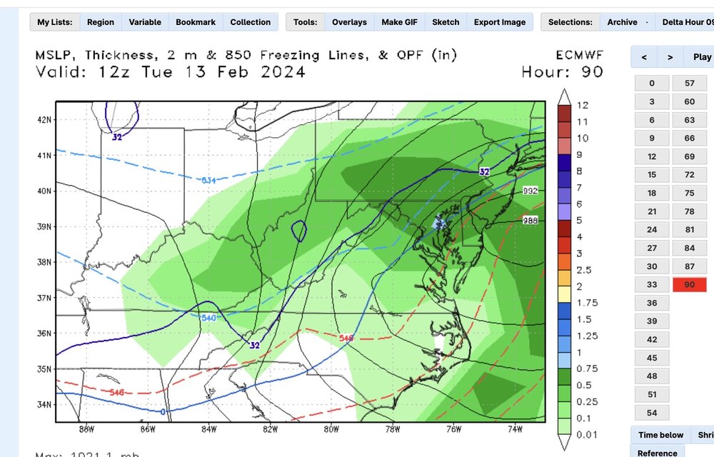
-
2024 Valentines Day Who the Hell Knows - Comeback Thread
stormtracker replied to DDweatherman's topic in Mid Atlantic
Precip field did take a small tilt to the south again. Again, stopped at 90, but the heavier precip that was up north was definitely smooshed down -
2024 Valentines Day Who the Hell Knows - Comeback Thread
stormtracker replied to DDweatherman's topic in Mid Atlantic
Stopped at 90...850 line just south of DC...moderate precip...and that's where it stopped...wetter down here vs 12z -
2024 Valentines Day Who the Hell Knows - Comeback Thread
stormtracker replied to DDweatherman's topic in Mid Atlantic
Precip axis moved a little south -
2024 Valentines Day Who the Hell Knows - Comeback Thread
stormtracker replied to DDweatherman's topic in Mid Atlantic
The vort is further back west and looks more south than it did at 12z -
2024 Valentines Day Who the Hell Knows - Comeback Thread
stormtracker replied to DDweatherman's topic in Mid Atlantic
Noticed that the precip field is more consolidated and heavier down south. -
2024 Valentines Day Who the Hell Knows - Comeback Thread
stormtracker replied to DDweatherman's topic in Mid Atlantic
s/w noticeably further west a bit...but not much to change anything it seems -
2024 Valentines Day Who the Hell Knows - Comeback Thread
stormtracker replied to DDweatherman's topic in Mid Atlantic
Some slight changes on the 12z...southern s/w held back just a tad -
I didn’t say it wasn’t better. Just still suppressed
-
It’s suppressed. Looks like it’s coming to get us and the light stuff hits DC then it’s exit stage right
- 2,509 replies
-
- 1
-

-
- weenie fest or weenie roast?
- weenies got roasted
- (and 2 more)
-
2024 Valentines Day Who the Hell Knows - Comeback Thread
stormtracker replied to DDweatherman's topic in Mid Atlantic
Hmm. Yeah that’s a little different. lol. -
2024 Valentines Day Who the Hell Knows - Comeback Thread
stormtracker replied to DDweatherman's topic in Mid Atlantic
lol. Not really. See yall for the 0z pbp -
2024 Valentines Day Who the Hell Knows - Comeback Thread
stormtracker replied to DDweatherman's topic in Mid Atlantic
RADIO SHOW *Tonight, join me, Bob Ryan, special guest Joe Bastardi -
2024 Valentines Day Who the Hell Knows - Comeback Thread
stormtracker replied to DDweatherman's topic in Mid Atlantic
Gfs blah. Took PSU snow away and shifted the axis north -
cute little wave amplifying in the midwest on the Euro...but the show is about to cut off on the next panel
-
2024 Valentines Day Who the Hell Knows - Comeback Thread
stormtracker replied to DDweatherman's topic in Mid Atlantic
Nope.....too easy. Don't do it Randy -
Euro has a southern wave..like way south into Mexico, but it won't be able to amplify. On to 18 and 0z!
-
Midlo. He's been MIA for the past few hours. Loved me some Midlo. He paved the way for RR. He crawled so RR could walk.
- 2,509 replies
-
- 3
-
-
- weenie fest or weenie roast?
- weenies got roasted
- (and 2 more)
-
Blast from the past...we need the laugh from last year. Definitely was my piece de resistance.
- 2,509 replies
-
- 3
-
-
- weenie fest or weenie roast?
- weenies got roasted
- (and 2 more)


