stormtracker
-
Posts
64,391 -
Joined
-
Last visited
Content Type
Profiles
Blogs
Forums
American Weather
Media Demo
Store
Gallery
Everything posted by stormtracker
-

The Weekend Rule? Saturday 2/17 - The Icon Storm
stormtracker replied to DDweatherman's topic in Mid Atlantic
SO FAR, doesn't seem to be drier than 6z...but urging caution..that's just to our west...just about to get to us and I can better tell -
The Weekend Rule? Saturday 2/17 - The Icon Storm
stormtracker replied to DDweatherman's topic in Mid Atlantic
Ok, coming into frame in a few...at 54, should be able to make a call at around 66 hours.... -
The Weekend Rule? Saturday 2/17 - The Icon Storm
stormtracker replied to DDweatherman's topic in Mid Atlantic
Come on son..i'm up to 42 -
The Weekend Rule? Saturday 2/17 - The Icon Storm
stormtracker replied to DDweatherman's topic in Mid Atlantic
Early yet...but a carbon copy of 6z so far -
The Weekend Rule? Saturday 2/17 - The Icon Storm
stormtracker replied to DDweatherman's topic in Mid Atlantic
I can't do that. This is the only time I can say this about myself and actually mean it: I gotta be straight with yall. -
The Weekend Rule? Saturday 2/17 - The Icon Storm
stormtracker replied to DDweatherman's topic in Mid Atlantic
Running now...may the odds be in our favor -
The Weekend Rule? Saturday 2/17 - The Icon Storm
stormtracker replied to DDweatherman's topic in Mid Atlantic
It's drier, but acceptable I'd say. -
The Weekend Rule? Saturday 2/17 - The Icon Storm
stormtracker replied to DDweatherman's topic in Mid Atlantic
2-4 south of FDK -Westminster like...1-3 north across to Mappy land -
The Weekend Rule? Saturday 2/17 - The Icon Storm
stormtracker replied to DDweatherman's topic in Mid Atlantic
starts at 3z Sat...definitely drier -
The Weekend Rule? Saturday 2/17 - The Icon Storm
stormtracker replied to DDweatherman's topic in Mid Atlantic
So far, seems like the other 12z mods...a little drier and souther -
The Weekend Rule? Saturday 2/17 - The Icon Storm
stormtracker replied to DDweatherman's topic in Mid Atlantic
I mean, I'd take the ICON without hesitation and call it a day -
The Weekend Rule? Saturday 2/17 - The Icon Storm
stormtracker replied to DDweatherman's topic in Mid Atlantic
Colder, but drier. Probably matches the Euro. Bit of a disappointment, but we got time to recover on the NAM. And it's the NAM, so... -
The Weekend Rule? Saturday 2/17 - The Icon Storm
stormtracker replied to DDweatherman's topic in Mid Atlantic
So far, NAM looking a bit dry and further south so far.... -
The Weekend Rule? Saturday 2/17 - The Icon Storm
stormtracker replied to DDweatherman's topic in Mid Atlantic
I hope your kid is out of school for the entirety of a week and you’re stuck playing outside every day while a cold, hostile wind blows drifts into your driveway and you can’t escape for days. I hope there are abandoned cars in your neighborhood and the main thoroughfare looks like a third world country with no snowplows. -
I’m getting weary.
-
GFS has a lot going on with the H5 look around 141 hours and after
- 2,509 replies
-
- 3
-

-
- weenie fest or weenie roast?
- weenies got roasted
- (and 2 more)
-
The Weekend Rule? Saturday 2/17 - The Icon Storm
stormtracker replied to DDweatherman's topic in Mid Atlantic
$4,985. per month -
The Weekend Rule? Saturday 2/17 - The Icon Storm
stormtracker replied to DDweatherman's topic in Mid Atlantic

-
The Weekend Rule? Saturday 2/17 - The Icon Storm
stormtracker replied to DDweatherman's topic in Mid Atlantic
Ok, shift south with higher accums. 4-6 touch the southern tip of DC (heh) and everthing south through the northern neck...2 to 4 DC north -
The Weekend Rule? Saturday 2/17 - The Icon Storm
stormtracker replied to DDweatherman's topic in Mid Atlantic
moderate snow with a southward shift of the heaviest band now centered over....DC -
The Weekend Rule? Saturday 2/17 - The Icon Storm
stormtracker replied to DDweatherman's topic in Mid Atlantic
Precip arrives 3z Sat. Smidge colder -
The Weekend Rule? Saturday 2/17 - The Icon Storm
stormtracker replied to DDweatherman's topic in Mid Atlantic
Hmm, NAM kinda interesting with that gulf low...gonna get shunted out to sea tho. Anyway, nam is just beginning over us at 84. Got nothing to compare it to...but yeah -
The Weekend Rule? Saturday 2/17 - The Icon Storm
stormtracker replied to DDweatherman's topic in Mid Atlantic
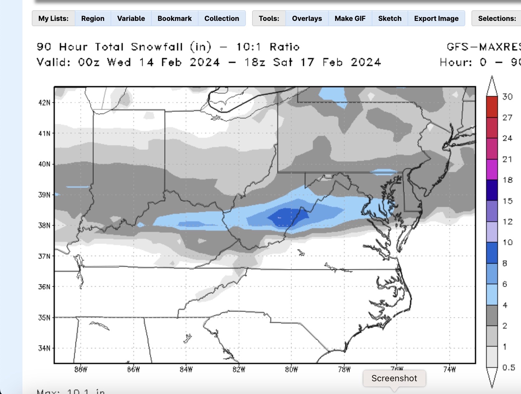
Also, remember, 18z Euro stops at 90. Precip was still ongoing...so could be a bit more accums -
The Weekend Rule? Saturday 2/17 - The Icon Storm
stormtracker replied to DDweatherman's topic in Mid Atlantic
Not as wet vs 12z.precip is a bit more norther oriented, but nothing significant. 1 to 4" area wide -
The Weekend Rule? Saturday 2/17 - The Icon Storm
stormtracker replied to DDweatherman's topic in Mid Atlantic
light to mod over the area around 9z...temps at freezing dc n and west during that time