stormtracker
-
Posts
64,401 -
Joined
-
Last visited
Content Type
Profiles
Blogs
Forums
American Weather
Media Demo
Store
Gallery
Everything posted by stormtracker
-

2024 Valentines Day Rain/Snow/Who The Hell Knows Thread
stormtracker replied to WinterWxLuvr's topic in Mid Atlantic
It’s drier. But still same temp profile -
2024 Valentines Day Rain/Snow/Who The Hell Knows Thread
stormtracker replied to WinterWxLuvr's topic in Mid Atlantic
I can’t compare shit, but I’m posting from the future. The money frames are almost in reach -
2024 Valentines Day Rain/Snow/Who The Hell Knows Thread
stormtracker replied to WinterWxLuvr's topic in Mid Atlantic
Could be. At least its not as dry as… -
2024 Valentines Day Rain/Snow/Who The Hell Knows Thread
stormtracker replied to WinterWxLuvr's topic in Mid Atlantic
I’m on my way to the gym homie. And i hate doing pbp on this phone. I can’t compare easily. You got this. I’ll take a look but won’t be able to quickly tell if it’s souther norther etc. -
2024 Valentines Day Rain/Snow/Who The Hell Knows Thread
stormtracker replied to WinterWxLuvr's topic in Mid Atlantic
Yeah I didn't realize this obviously right after the deflating 12z op run. It does bring back the interest level for me -
2024 Valentines Day Rain/Snow/Who The Hell Knows Thread
stormtracker replied to WinterWxLuvr's topic in Mid Atlantic
I dunno...I'm just very skeptical. If 18z keeps it, I'll be excited for the 0z run...but I'm pretty sure the GFS is going to cave with either run. -
2024 Valentines Day Rain/Snow/Who The Hell Knows Thread
stormtracker replied to WinterWxLuvr's topic in Mid Atlantic
Hmm. This was a pretty big shift. We'll probably get a compromise, which isn't gonna do it for us. -
2024 Valentines Day Rain/Snow/Who The Hell Knows Thread
stormtracker replied to WinterWxLuvr's topic in Mid Atlantic
Well, that was anti climatic. Mt PSU has a trace on this run. GFS should cave at 18z/0z -
2024 Valentines Day Rain/Snow/Who The Hell Knows Thread
stormtracker replied to WinterWxLuvr's topic in Mid Atlantic
LOL, the gfs just starts to get going at 9z Tuesday and the Euro has the thing north of us about to exit stage right -
2024 Valentines Day Rain/Snow/Who The Hell Knows Thread
stormtracker replied to WinterWxLuvr's topic in Mid Atlantic
The Euro isn't buying what the GFS is selling -
2024 Valentines Day Rain/Snow/Who The Hell Knows Thread
stormtracker replied to WinterWxLuvr's topic in Mid Atlantic
I think I safely say that it won't be like the GFS. Also rain gets in faster vs GFS -
2024 Valentines Day Rain/Snow/Who The Hell Knows Thread
stormtracker replied to WinterWxLuvr's topic in Mid Atlantic
Don't know if it's just slower, but the s/w in the south is a tad bit souther....still too early to call. So I won't -
2024 Valentines Day Rain/Snow/Who The Hell Knows Thread
stormtracker replied to WinterWxLuvr's topic in Mid Atlantic
ok, gonna switch to comparing it to 0z.....as you know 6z only goes to 90, so we're past that time period...and again, the northern streamer movement is pretty significant vs 6z -
2024 Valentines Day Rain/Snow/Who The Hell Knows Thread
stormtracker replied to WinterWxLuvr's topic in Mid Atlantic
81 hours nothern streamer is ahead by a good bit vs 6z -
2024 Valentines Day Rain/Snow/Who The Hell Knows Thread
stormtracker replied to WinterWxLuvr's topic in Mid Atlantic
Differences are a bit more apparent at 75...northern streamer is out a head a little bit more and southern streamer is back to the southwest a little more -
2024 Valentines Day Rain/Snow/Who The Hell Knows Thread
stormtracker replied to WinterWxLuvr's topic in Mid Atlantic
Seeing some subtle changes...southern sw is a bit more southwester than 6z.... by 60 hours is pretty evident and slightly more separation between the northern and southern wave -
2024 Valentines Day Rain/Snow/Who The Hell Knows Thread
stormtracker replied to WinterWxLuvr's topic in Mid Atlantic
So far, no remarkable changes vs 6z, but it's super early in the game... -
2024 Valentines Day Rain/Snow/Who The Hell Knows Thread
stormtracker replied to WinterWxLuvr's topic in Mid Atlantic
Gonna be comparing to 6z until 84 hours, then it will be 0z -
2024 Valentines Day Rain/Snow/Who The Hell Knows Thread
stormtracker replied to WinterWxLuvr's topic in Mid Atlantic
Ok, yall....let's see what this episode of the Euro brings... -
2024 Valentines Day Rain/Snow/Who The Hell Knows Thread
stormtracker replied to WinterWxLuvr's topic in Mid Atlantic
Honestly, it's hard to get excited with the Euro and lesser models are not in the neighborhood of the GFS. But maybe the Euro will fold... -
2024 Valentines Day Rain/Snow/Who The Hell Knows Thread
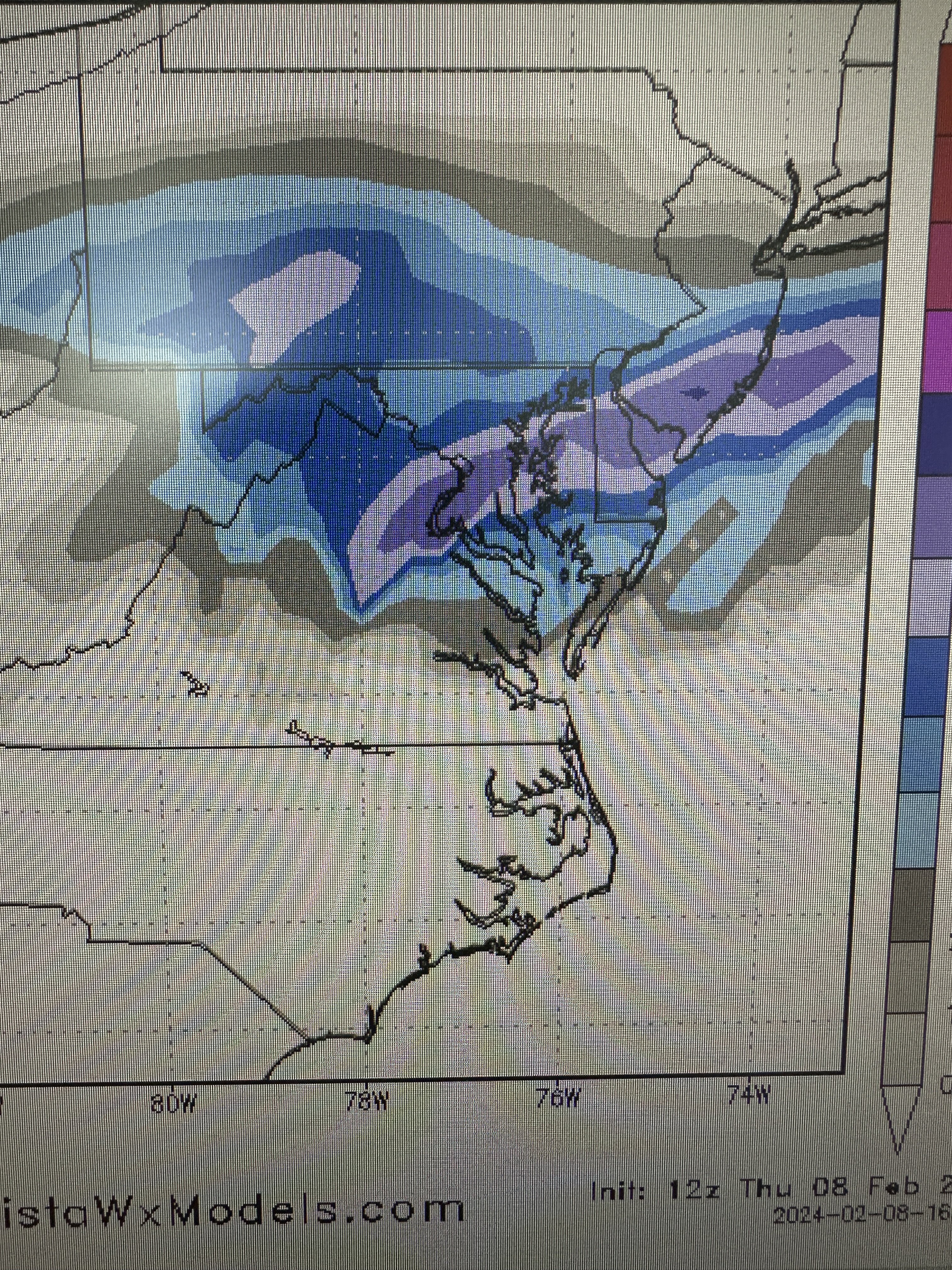
stormtracker replied to WinterWxLuvr's topic in Mid Atlantic
sorry for the shitty pic of a pic...it's quicker than all that screen shot on a PC -
2024 Valentines Day Rain/Snow/Who The Hell Knows Thread
stormtracker replied to WinterWxLuvr's topic in Mid Atlantic
-
2024 Valentines Day Rain/Snow/Who The Hell Knows Thread
stormtracker replied to WinterWxLuvr's topic in Mid Atlantic
Lol...DC 10-12 -
2024 Valentines Day Rain/Snow/Who The Hell Knows Thread
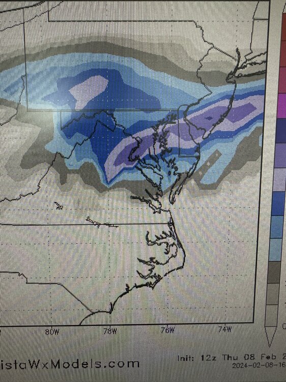
stormtracker replied to WinterWxLuvr's topic in Mid Atlantic
Much more QPF vs 6z -
2024 Valentines Day Rain/Snow/Who The Hell Knows Thread
stormtracker replied to WinterWxLuvr's topic in Mid Atlantic
FOLKS... 21z much heavier precip vs 6z..850 south of us- 563 replies
-
- 21
-

-

-

-