

Iceagewhereartthou
-
Posts
1,906 -
Joined
-
Last visited
Content Type
Profiles
Blogs
Forums
American Weather
Media Demo
Store
Gallery
Everything posted by Iceagewhereartthou
-
Didn't see a place to discuss this in the regional forum so here's a thread. I am just beginning to try searching though everything so many of you may know how to better find the information quickly and post graphs etc. Here's the link I'm using to find cities: https://www.ncei.noaa.gov/access/us-climate-normals/ Greer (Avg High, Low, Monthly Avg, Rain, and Snow) GSP appears to be about .5-1 degree warmer most temps. Jan 52.8 32.1 42.5 4.12 1.6 Feb 57.0 34.8 45.9 3.84 1.0 Mar 64.4 41.2 52.8 4.48 0.6 Apr 73.2 48.7 61.0 4.04 0.0 May 80.3 57.5 68.9 4.07 0.0 Jun 87.2 65.5 76.3 3.90 0.0 Jul 90.3 69.2 79.7 4.82 0.0 Aug 88.5 68.3 78.4 4.66 0.0 Sep 82.7 62.4 72.5 3.73 0.0 Oct 73.1 50.4 61.7 3.59 0.0 Nov 62.9 40.4 51.6 3.84 0.1 Dec 54.9 34.8 44.8 4.58 0.6
-
High of just 55.2 today. 1.42 in rain, more coming.
-
29.5 for me. 27 at Pickens County airport SC.
-
Mid to Long Term Discussion 2021
Iceagewhereartthou replied to jburns's topic in Southeastern States
I, for one, am LOVING the dryer weather. After more than 250 inches of rain since Jan 2018, a couple weeks without floods is nice indeed! -
Winter 2020-2021 whining thread
Iceagewhereartthou replied to BullCityWx's topic in Southeastern States
Wow, GSP not forecast to go below 41 over the next 15 days! That's rediculous, this isn't April. -
Winter 2020-2021 whining thread
Iceagewhereartthou replied to BullCityWx's topic in Southeastern States
Well fellas, I'm not forecasted to get below freezing again on the 16 day so I have officially thrown the towel on winter this year. Getting (appreciable) winter weather after March 10th has only happened a couple of times in my lifetime. I'll wait to give my official winter grade till April (I know everyone is waiting with bated breath). The mountains may still do well but I think it's about over for my area. -
Winter 2020-2021 whining thread
Iceagewhereartthou replied to BullCityWx's topic in Southeastern States
Just the latest example of a CAD not always over performing. That's the biggest myth repeated on the board. -
February 18-19 MAJOR Ice Storm Threat
Iceagewhereartthou replied to NorthHillsWx's topic in Southeastern States
Made it down to about 41, clouds came in, back up to 42.5 quickly, DP 30. -
February 18-19 MAJOR Ice Storm Threat
Iceagewhereartthou replied to NorthHillsWx's topic in Southeastern States
Some roads near Easley have been brined, I guess bc of the WWA. Not expecting any issues here though. -
February 18-19 MAJOR Ice Storm Threat
Iceagewhereartthou replied to NorthHillsWx's topic in Southeastern States
At least the southern portion of your house will still have power! -
Mid to Long Term Discussion 2021
Iceagewhereartthou replied to jburns's topic in Southeastern States
Wow guys, this is one time I'm happy to be in the upstate and not in WNC. I hope this trends to sleet or warms to rain for you guys, that kind of ice would be AWFUL. -
Mid to Long Term Discussion 2021
Iceagewhereartthou replied to jburns's topic in Southeastern States
Wow, most of us would have put money on that kind of setup. Simply amazing. -
Winter 2020-2021 whining thread
Iceagewhereartthou replied to BullCityWx's topic in Southeastern States
Based on what was advertised, almost unanimously, it's one of the bigger disappointments and rip offs I can remember. Definitely hard to swallow. -
Winter 2020-2021 whining thread
Iceagewhereartthou replied to BullCityWx's topic in Southeastern States
The biggest way we know this next week is a lost cause is that Burrel stopped posting. That says it all. -
Winter 2020-2021 whining thread
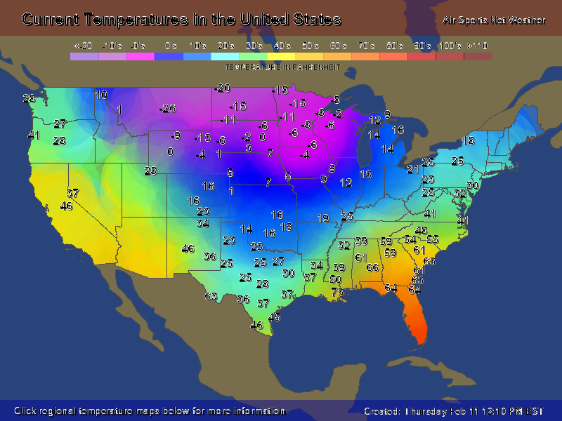
Iceagewhereartthou replied to BullCityWx's topic in Southeastern States
And here's today's image. Again,the position of the trough and SER are very clear. Unfortunately this looks to be the case for the next week leaving us in the warm and wet sector. Just too bad we could get it to move East!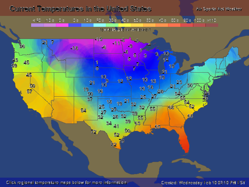
-
Winter 2020-2021 whining thread
Iceagewhereartthou replied to BullCityWx's topic in Southeastern States
This is the current map. It really shows the tough in the middle of the country and this seems to have been the prevailing pattern this year, with almost no movement East. It's strange, despite not having a major SER this year it's been there enough to keep out the true cold. Next week the cold looks to be magnified and epanded a bit East to LA/MS/AL, but basically seems to stay in place.
-
Mid to Long Term Discussion 2021
Iceagewhereartthou replied to jburns's topic in Southeastern States
And maybe multiple ones. This could be their March 1960 pattern. What a week to 10 days they are in store for based on the overall pattern evolution and the amount of cold on that side of the apps. -
Winter 2020-2021 whining thread
Iceagewhereartthou replied to BullCityWx's topic in Southeastern States
Just maddening to have that level of cold at the same latitude a few hundred miles away and hardly get a piece of it. 60 degrees difference b/w Columbia SC and Jackson MS! -
Mid to Long Term Discussion 2021
Iceagewhereartthou replied to jburns's topic in Southeastern States
Fair enough! -
Mid to Long Term Discussion 2021
Iceagewhereartthou replied to jburns's topic in Southeastern States
Excellent post. I think negative tilt is pretty hard to forecast, especially this far out. This solution is factoring it in, but it's one detail of the whole picture that has a drastic effect on the outcome. If that tilt were not part of this particular run, think about how that might change the output of the storm. The low may be much father south, weaker, and allow the cold high confluence to remain longer and stronger. The model could easily change that particular detail in a future run and then we have an icy and colder solution again. Way too much time to go on this one. The ingredients are there, but we likely won't have a good idea till Sun or Monday, if not even go time. I still don't think we have a great picture of this weekend's system. -
Winter 2020-2021 whining thread
Iceagewhereartthou replied to BullCityWx's topic in Southeastern States
What is a playoff? -
Winter 2020-2021 whining thread
Iceagewhereartthou replied to BullCityWx's topic in Southeastern States
Hope it works better for you than it does for us. -
Winter 2020-2021 whining thread
Iceagewhereartthou replied to BullCityWx's topic in Southeastern States
Did you get blanked? -
Mid to Long Term Discussion 2021
Iceagewhereartthou replied to jburns's topic in Southeastern States
Oh, I wasn't disputing you or anything in particular. Really just thinking out loud, not that I know anything. I would honestly like to see some sustained cold, even if it doesn't deliver snow. I've only seen one real cold front this year; the one around Christmas, and that only lasted a couple of days. Everything else has either been seasonable or just below. Despite the persistent -NAO Aand muted SER we have just struggled at getting any real cold across the apps or south of northern VA. -
Mid to Long Term Discussion 2021
Iceagewhereartthou replied to jburns's topic in Southeastern States
Some interesting run trends today, definitely have to watch the next few days to see what happens. The trend this year has been for the cold to stay West of the apps, and many of the runs continue to show the cold having difficulty making it east of the mtns. Maybe it makes it this time but I would not be surprised to see marginal cold again for most. Looks like we should be paying attention for the next 10 to 15 days though for sure.


