GaWx
-
Posts
19,136 -
Joined
Content Type
Profiles
Blogs
Forums
American Weather
Media Demo
Store
Gallery
Everything posted by GaWx
-
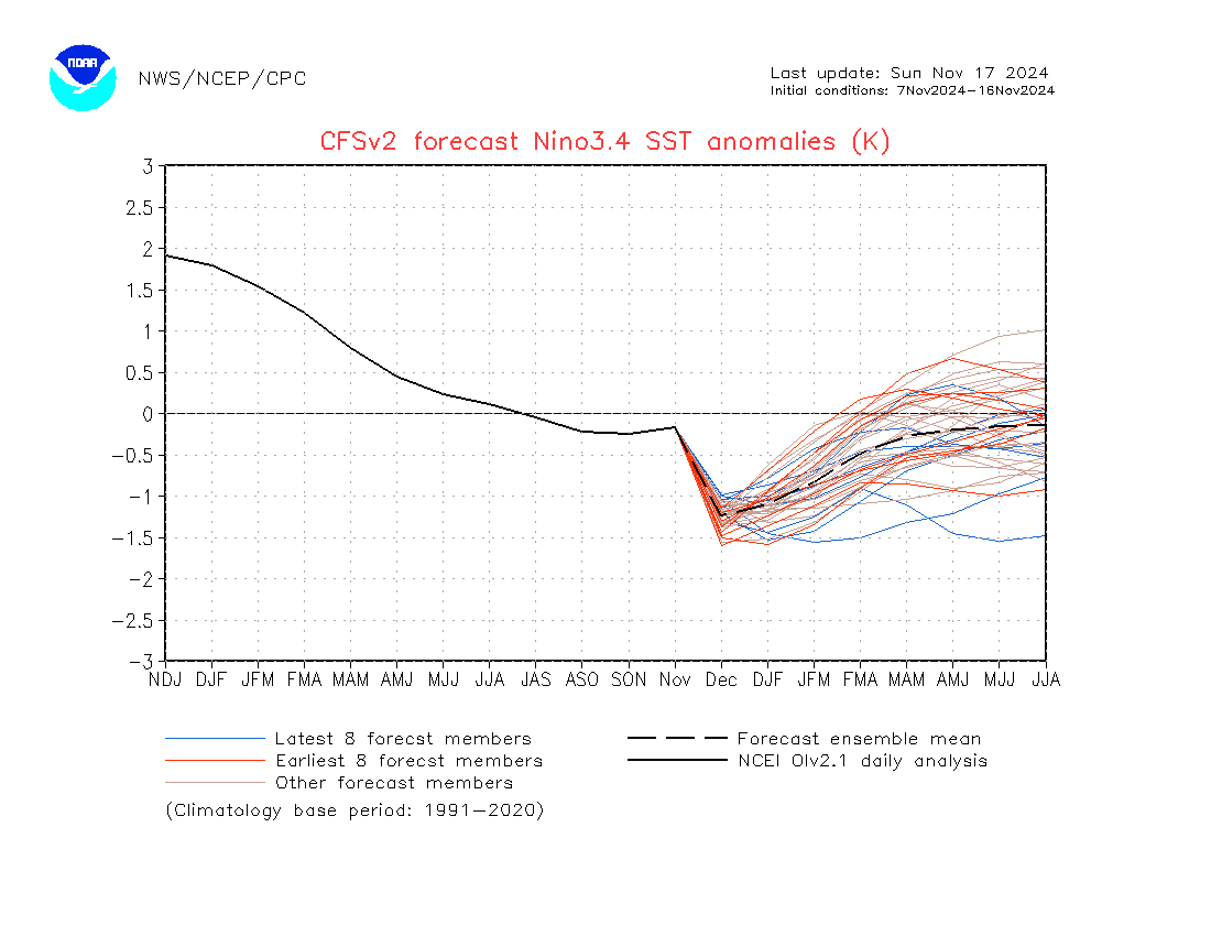
So based on my prior post: IF the CFS cooling in Nino 3.4 from Nov to Dec were to somehow verify closely, it would more than double the old record cooling from Nov to Dec back to 1950 and more than triple the strongest forecasted cooling of any other model (JMA’s 0.3)! For some reason I feel CFS will bust very badly but we’ll see. In light of this likely upcoming huge bust in Nino 3.4, how much weight should be put on the CFS current winter forecast for the E US?
-
What’s the deal with the latest CFS forecasted record rate of cooling from Nov to Dec in Nino 3.4? The latest CFS mean is forecasting a record shattering cooling of 1.0 to -1.2: Compare the CFS to these latest runs for Nov to Dec: -BoM: no cooling/remain at -0.2 -Euro: 0.25 cooling to -0.5 -JMA: 0.3 cooling to -0.6 -MeteoFrance: 0.2 cooling to -0.45 -UKMET: 0.2 cooling to -0.8 So, CFS’ cooling of 1.0 from Nov to Dec compares to a range of only 0.0 to 0.3 for the latest run of the other five models. The record ONI based cooling from Nov to Dec back to 1950 is only 0.45 (1951) followed by 0.41 (1954) and 0.40 (2008 and 2012)! The record warming from Nov to Dec is only 0.43 (1991). https://www.cpc.ncep.noaa.gov/products/analysis_monitoring/ensostuff/detrend.nino34.ascii.txt

-
I don’t know. It’s way too early for any forecaster to even try to determine that.
-
Yes, 2004 and 1969 were both weak El Niño with active Atlantic hurricane seasons.
-
In general terms El Niño is correlated with less ACE than non-Nino. But if it’s weak, there’s typically less of a reduction. Furthermore, this is only a tendency. For example, look at 2023 for a major exception due to record high Atlantic SSTs.
-
1. On RONI basis, which is much more telling of late, 2023 peaked at only +1.50 vs 2015-6 at +2.37, 1997-8 at +2.38, 1982-3 at +2.53, 1972-3 at +2.27, and 1965-6 at +2.04. So, on that basis, 2023 doesn’t belong with the other 5. 2. Per RONI 1963-4 peaked at +1.25, not that much weaker than 2023, and went Nino, Niña, Nino. 3. Per Webb, 1902-3 peaked a bit stronger than 2023 (+1.8) and went Nino, Niña, Nino. 4. Per Webb 1885-6 peaked at +1.3, not that much weaker than 2023 and went Nino, Niña, Nino. So, I maintain that a Nino in 2025-6 wouldn’t be an all that rare occurrence. I think the previously stated rareness is being overblown.
-
Regarding the bolded: -2004,5,6 was Nino, Niña, Nino -1963,4,5 was the same -1923,4,5 “ “ -1902,3,4 “ “ -1885,6,7 “ “ -Since 1851 there were 19 cases of Nino to Niña. Out of these 19, 5 ended up Nino to Niña to Nino. -So, they’re not as rare as one might think. -Last 3 runs of CANSIPS have been showing Modoki Nino next summer fwiw.
-
1. If this leads to <3” of SN in Dec at NYC, look for Jan+ SN to likely be solidly BN per bluewave’s stats. 2. I just looked at the comparison of US HDDs for 11/23-27 on the 0Z 11/14 EPS and the same on both the 12Z 11/15 and 0Z 11/16 runs. The warming was strong as it went from an average of 0.5 AN HDDs to 3+ BN HDDs! Whereas the 0Z 11/14 run had 4 days with AN HDDs, the last 2 runs had no days like that! Is this a sign of what’s to come this winter on the EPS? Are the various ensembles going to once again be cold biased much of the time like has been the case for much of the last 7-8 years?
-
Euro Weeklies mean over last couple of days has reverted back to a strong SPV throughout Dec: today’s is as strong as any run yet
-
-
Flooding in Honduras from Tropical Storm Sara on November 15, 2024 (CREDIT: CNN) https://www.kadn.com/weather/hurricane/tropical-storm-sara-meanders-near-northern-honduras-after-landfall/article_365d0808-9dbc-51d7-90af-7c76b565b5c9.html
-
Assuming this story by CNN is accurate, this is very bad news for much of N Honduras being that heavy rains are forecasted to continue for parts of that area the next 24-48 hours: “Tropical Storm Sara is unleashing heavy rainfall in northeastern Honduras, with life-threatening flash flooding and mudslides anticipated through the weekend. Nearly 20 inches of rain had already fallen in parts of Honduras as of Friday morning with more to come.” https://amp.cnn.com/cnn/2024/11/14/weather/tropical-storm-sara-florida-hurricane-season-climate The following from NHC is regarding ADDITIONAL rainfall expected: this when combined with what’s already fallen (mainly in NE Honduras) is unfortunately probably just about as bad as it can get in general for that area due mainly to very slow movement but also warmer than normal SSTs allowing more moisture to be held via higher dewpoints: Here’s the latest NHC storm total forecast: RAINFALL: Through early next week, rainfall amounts of 15 to 25 inches with isolated storm totals around 35 inches area expected over northern Honduras. This rainfall will lead to widespread areas of life-threatening and potentially catastrophic flash flooding and mudslides, especially along and near the Sierra La Esperanza. Compare that to the prior storm total rainfall forecast: RAINFALL: Through early next week, rainfall amounts of 10 to 20 inches with isolated storm totals around 30 inches area expected over northern Honduras.
-
1. Colder phases outside the circle in winter averaged colder than inside the circle for warm phases in my own studies, especially in or near midwinter. But I found amplitude of 0.5 to 1.5 left side to be colder in the means than 1.5+ left side. 2. The following is from that same outside study (that I found after doing my own analyses) but just for winter: just outside circle and inside the circle MJO (amp of <1.5) averaged colder than stronger (>1.5):
-
I found in my multidecadal analyses for winter that stronger amplitude of MJO hasn’t correlated to colder in the E US in the means. I actually found the opposite: weaker tended to be colder (in the means). After doing my own analyses, I then found this (for all seasons), which agrees with my findings that cold in the E US correlates best with weak MJO rather than strong:
-
I agree with the bolded. Thus due to Euro ensemble often being too weak going into the right side of the diagram, I’ve found the GEFS to be about the most accurate of the models going into the right side. Currently the EPS is much weaker as you stated.
-
Overall trends since 0Z today in EPS/GEFS have been milder for late in the runs (last few days of Nov) resulting in a drop in HDDs. This helped NG prices close down 6% since yesterday. NG prices are an excellent barometer of the latest tendencies in the week 2 trend, often especially days 10-15, in E US modeled temperatures. We’ll see what tomorrow brings. Regardless, a refreshingly chilly (NN to BN) period looks to be on the way for much of 11/21-6 in the bulk of the E US. Enjoy!
-
I have found the GEFS and Euro Ens to be the best for MJO predictions and the CFS and BoM (which were often way too amplified last winter) to be the worst. JMA/CMC in between/harder to tell since don’t go out as far. I know JB likes to look at the JMA as gold standard for MJO forecasting, which has bitten him a number of times.
-
For NYC during La Niña (which will likely verify on RONI basis), the Dec snowfall was a very good indicator for the rest of the season’s snowfall there as @bluewaveand/or @donsutherland1showed. So, it will be quite interesting to see where their Dec snowfall ends up.
-
TD 19 has become TS Sara: devastating rainfall in N Honduras and nearby is the main danger: Tropical Storm Sara Intermediate Advisory Number 4A NWS National Hurricane Center Miami FL AL192024 100 PM EST Thu Nov 14 2024 ...DEPRESSION STRENGTHENS INTO TROPICAL STORM SARA... ...LIFE-THREATENING AND POTENTIALLY CATASTROPHIC FLASH FLOODING AND MUDSLIDES EXPECTED IN HONDURAS THROUGH THE WEEKEND... SUMMARY OF 100 PM EST...1800 UTC...INFORMATION ---------------------------------------------- LOCATION...15.7N 82.9W ABOUT 205 MI...330 KM ESE OF ISLA GUANAJA HONDURAS ABOUT 50 MI...85 KM NE OF CABO GRACIAS A DIOS ON NIC/HON BORDER MAXIMUM SUSTAINED WINDS...40 MPH...65 KM/H PRESENT MOVEMENT...W OR 265 DEGREES AT 12 MPH...19 KM/H MINIMUM CENTRAL PRESSURE...999 MB...29.50 INCHES DISCUSSION AND OUTLOOK ---------------------- At 100 PM EST (1800 UTC), the center of Tropical Storm Sara was located by Air Force Reserve reconnaissance aircraft near latitude 15.7 North, longitude 82.9 West. The system is moving toward the west near 12 mph (19 km/h). This motion should continue through today, bringing the center near the coast of eastern Honduras. The system is expected to meander near the northern coast of Honduras late Friday and through the weekend. Data from the Air Force Reserve aircraft indicate that the maximum sustained winds have increased to near 40 mph (65 km/h) with higher gusts. Some strengthening is possible, if the system remains over water. Tropical-storm-force winds extend outward up to 70 miles (115 km) from the center, mainly in the northern semicircle. The estimated minimum central pressure based on dropsonde data is 999 mb (29.50 inches). RAINFALL: Through early next week, rainfall amounts of 10 to 20 inches with isolated storm totals around 30 inches area expected over northern Honduras. This rainfall will lead to widespread areas of life-threatening and potentially catastrophic flash flooding and mudslides, especially along and near the Sierra La Esperanza. Elsewhere across the rest of Honduras, Belize, El Salvador, eastern Guatemala, and western Nicaragua, Tropical Storm Sara is expected to produce 5 to 10 inches of rain with localized totals around 15 inches through early next week. This will result in areas of flash flooding, perhaps significant, along with the potential of mudslides.
-
Here’s the latest chart showing the Euro ensemble mean’s forecasted US pop weighted HDD (on left)(green is normal): the 0Z (purple) lost 5 HDD vs yesterday’s 12Z (yellow), which helped to cause NG prices to drop moderately (now down ~4% vs yesterday)(edit: ended ~6% down at close). As Chuck knows, NG price trends are often a good barometer of changing trends of the forecasted upcoming E US wx (especially in the E US out 7-14 days): coldest days of this period still look to be 11/23-6:
-
Here’s the projected rainfall for Honduras, which I’m thinking will end up the big news story from this storm: For comparison, here is the estimated rainfall from the devastating Eta in 2020, which caused horrible river flooding in Honduras and looks pretty similar to the current storm
-
Potentially devastating flooding for N Honduras similar to Eta/Iota of 2020 and Mitch of 1998 due to extremely slow movement: dire situation there BULLETIN Tropical Depression Nineteen Advisory Number 4 NWS National Hurricane Center Miami FL AL192024 1000 AM EST Thu Nov 14 2024 ...LIFE-THREATENING AND POTENTIALLY CATASTROPHIC FLASH FLOODING AND MUDSLIDES EXPECTED IN HONDURAS THROUGH THE WEEKEND... SUMMARY OF 1000 AM EST...1500 UTC...INFORMATION ----------------------------------------------- LOCATION...15.7N 82.6W ABOUT 225 MI...365 KM ESE OF ISLA GUANAJA HONDURAS ABOUT 65 MI...100 KM NE OF CABO GRACIAS A DIOS ON NIC/HON BORDER MAXIMUM SUSTAINED WINDS...35 MPH...55 KM/H PRESENT MOVEMENT...W OR 265 DEGREES AT 14 MPH...22 KM/H MINIMUM CENTRAL PRESSURE...1004 MB...29.65 INCHES WATCHES AND WARNINGS -------------------- CHANGES WITH THIS ADVISORY: The government of Honduras has discontinued the Hurricane Watch for Honduras and the Bay Islands. SUMMARY OF WATCHES AND WARNINGS IN EFFECT: A Tropical Storm Warning is in effect for... * The northern coast of Honduras form Punta Sal eastward to the Honduras/Nicaragua Border * The Bay Islands of Honduras A Tropical Storm Watch is in effect for... * The northeastern coast of Nicaragua from Puerto Cabezas northward to the Honduras/Nicaragua Border A Tropical Storm Warning means that tropical storm conditions are expected somewhere within the warning area. A Tropical Storm Watch means that tropical storm conditions are possible within the watch area, generally within 48 hours. Interests elsewhere in Honduras, Guatemala, Belize and the Yucatan Peninsula should monitor the progress of this system. For storm information specific to your area, please monitor products issued by your national meteorological service. DISCUSSION AND OUTLOOK ---------------------- At 1000 AM EST (1500 UTC), the center of Tropical Depression Nineteen was located near latitude 15.7 North, longitude 82.6 West. The depression is moving toward the west near 14 mph (22 km/h). This motion should continue through today, bringing the center near the coast of eastern Honduras. The system is expected to meander near the northern coast of Honduras late Friday and through the weekend. Maximum sustained winds are near 35 mph (55 km/h) with higher gusts. Some strengthening is forecast and the system is forecast to become a tropical storm later today. The estimated minimum central pressure is 1004 mb (29.65 inches). RAINFALL: Through early next week, rainfall amounts of 10 to 20 inches with isolated storm totals around 30 inches area expected over northern Honduras. This rainfall will lead to widespread areas of life-threatening and potentially catastrophic flash flooding and mudslides, especially along and near the Sierra La Esperanza. FORECAST POSITIONS AND MAX WINDS INIT 14/1500Z 15.7N 82.6W 30 KT 35 MPH 12H 15/0000Z 15.7N 83.7W 35 KT 40 MPH 24H 15/1200Z 15.9N 84.9W 40 KT 45 MPH...NEAR THE COAST 36H 16/0000Z 15.9N 85.4W 40 KT 45 MPH...NEAR THE COAST 48H 16/1200Z 15.9N 85.8W 40 KT 45 MPH...NEAR THE COAST 60H 17/0000Z 16.0N 86.2W 45 KT 50 MPH...NEAR THE COAST 72H 17/1200Z 16.2N 87.0W 45 KT 50 MPH...OVER WATER 96H 18/1200Z 18.0N 89.6W 30 KT 35 MPH...INLAND 120H 19/1200Z 21.7N 91.6W 30 KT 35 MPH...OVER WATER $$ Forecaster Kelly
-
Mine too. I got ~1,000% of my climo mean liquid equivalent of wintry precip (all from one storm in early 1/2018), which is the largest since 1921-2! The one in late 1/1922 was the predecessor to the NE US’ Knickerbocker Storm. The snow/sleet combo portion of 1/2018 was the heaviest since the great 12/1989 coastal pre-Christmas near blizzard.
-
These 12Z model runs all have 20”+ of rainfall over part of N Honduras: GFS, Euro, Icon, and CMC. Add to that the 6Z Euro-AIFS. This is the kind of rainfall that can lead to another flooding disaster, especially if the track is a little further south. This kind of resembles the Mitch track, which also caused a flooding disaster there and nearby and resulted in 11K++ deaths. FL would likely only be a minor concern in comparison:
-
https://s2s.worldclimateservice.com/climatepanel/ Then click on PDO, which is 2nd graph down on right.