GaWx
Members-
Posts
18,478 -
Joined
Content Type
Profiles
Blogs
Forums
American Weather
Media Demo
Store
Gallery
Everything posted by GaWx
-
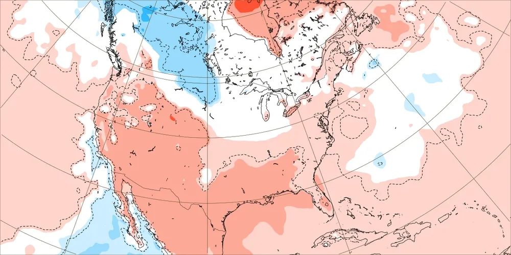
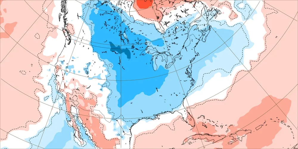
Thanks, Chuck. I just looked for the first time since yesterday. I see what you’re saying. But the latest GEFS/EPS are still pretty solidly cold dominated through day 16/15 in the E US with E US troughing. And trying to predict a few days later is full of danger as even predicting late week 2 isn’t so easy as we all know. Now are the full runs subtlety warmer than yesterday’s full runs while still quite cold? That’s very hard to determine without the actual HDD output, which I haven’t seen in awhile. Some of the 2M temperature change maps suggest that. And after a huge runup in NG to 13 month highs, that as you know could easily be all it takes for lots of profit-taking, especially if inventory is on the relative high side.
-
I just noticed that NG is currently down ~7% from yesterday. I don’t know why it is down sharply. Often that is a sign that the most recent EPS/GEFS runs are warmer than prior runs in the E US especially on days 8-16. But sometimes that can be due to other factors like lots of profit-taking after a huge runup that had actually occurred through yesterday. Also, yesterday had a weekly inventory report, which could have been bearish. I’ll see if I can find out. Admittedly I haven’t checked the latest EPS/GEFS. Anyone know if they’re as cold in the E 1/3 if the US as yesterday’s very cold runs?
-
-
Natural gas is now up a whopping 7% for the day and is at its highest since way back in Oct of 2023. To those who don’t know, NG price trends reflect well on the trend in EPS and GEFS forecasted E US temperatures, especially for days 10-16. When there’s a day with a significant drop (eventually it has to happen), that would tell me without looking at the ensembles that the colder ensemble E US trend very well may have stopped.
-
Lows in the area 43 (Hunter) and 45 (airport). Coldest overall of season to date. Even colder next 3 mornings is expected.
-
0Z GEFS and EPS at least appear to be the coldest runs yet for the E US! NG is once again at new highs (up 3%), highest since Jan.
-
0Z GFS has FIVE Canadian highs bring cold air down into the E US! That’s a relative rarity even for the GFS. NYC gets not just one but two measurable snowfalls fwiw.
-
0Z GFS has FIVE Canadian highs bring cold air down into the SE US! That’s a relative rarity even for the GFS. The NC mtns get 4 different NW flow accumulating events!
-
Very windy here this late evening. Hearing debris hit the roof. Dewpoints were near 60 just 3 hours ago and have fallen to 40 to upper 30s. This is a heck of a cold front!
-
Of the operationals over the last month, it looks like Euro 1st and UKMET 2nd at H5 (day 5). But look what’s in 3rd: CMC, which isn’t much behind UKMET! That tells me that if this month is representative of the longer term, the CMC may be the most improved op at H5 (at least at 120 hrs) over the last 10 years or so. In 4th is GFS. Bringing up the rear: the very unreliable CFS.
-
Being 160+ barely makes it officially hyperactive. Plus this might be raised in the post-season analyses.
-
I’ve been posting in the main La Niña forecasting thread. However, these posts have been addressing changes from run to run of overall US temperatures/heating degree days (especially E US) on EPS but also some GEFS runs as opposed to narrowed to SE US temperatures or winter storm threats. As a part of that I’ve been following natural gas mkt prices, which are often a good gauge of E US ensemble HDD forecasts in week 2. Example: today’s NG high was the highest since Jan! I also in there post about various indices and ENSO SSTa’s. Looking forward to the cooldowns!
-
NG is noting the overall colder GEFS/EPS so far today with it up a whopping 7%! Today’s high is the highest since way back in January!
-
With the 0Z EPS being significantly colder in the E US vs the 12Z run overall on days 7-15, NG is up to session highs. The coldest in late in the run (early Dec), when it is much BN with a hard freeze implied in much of the E US on 1-2 mornings. This cold is being driven by a solid -EPO/-WPO.
-
The 11/17 daily EPO of +233 (the latest daily available), which was the highest daily since way back on June 4, will probably end up being the highest for quite awhile. Models are unanimous in dropping it very sharply to at or near the lowest daily of 2024 on 11/21 or 11/22 (~-250)! The consensus then has it remaining negative the rest of Nov fwiw. When combining the low point and duration of this upcoming -EPO, it could end up the most impressive since way back in Oct of 2023! https://downloads.psl.noaa.gov/Public/map/teleconnections/epo.reanalysis.t10trunc.1948-present.txt
-
I’m not aware of any that are free. I can tell you that 11/17’s +233 (the latest daily available), which was the highest daily since way back on June 4, will probably end up being the highest for quite awhile. Models are unanimous in dropping it very sharply to at or near the lowest daily of 2024 on 11/21 or 11/22 (~-250)! The consensus then has it remaining negative the rest of Nov fwiw. When combining the low point and duration of this upcoming -EPO, it could end up the most impressive since way back in Oct of 2023! https://downloads.psl.noaa.gov/Public/map/teleconnections/epo.reanalysis.t10trunc.1948-present.txt
-
1. 12Z GEFS/EE appear to my eyeballs to probably have little change in total US pop weighted HDDs vs their respective prior runs. 2. OMG, there’s finally now an OMG reaction! Wow! This was much needed.
-
How are the autumn leaf colors currently looking in NC and other areas in relation to peak? Down here the first leaves have only just started to turn and hardly any have fallen. Thus a peak here in early to possibly as late as mid Dec would be my guess. The late week cooldown with coldest lows getting to down ~40 should really wake them up. The lowest in much of this region to date has been down only to the mid to upper 40s, with upper 40s the climo avg for today.
-
Through the 0Z/6Z EPS/GEFS the colder late solutions are continuing. NG is up near multi-session highs as a result. *Edit for 12Z GFS fwiw showing hard freezes much of E/SE US early Dec.
-
The left side of the image below shows the cooling of the 12Z EPS (purple) vs 0Z (yellow) by 6 HDD along with the coldest days being at the end, which helped NG to close in the higher portion of its session range (its lowest of session was before the 12Z models were released thanks largely to the then 10 HDD cooler Mon 0Z EPS vs Sun’s 12Z run). Again, it will be interesting to see as said by Huffman above whether this next progged cold period gets muted like was the case with late 11/24-7 as a new SE ridge appeared seemingly out of nowhere. This underplaying of the SE ridge has been a forecast problem for years coincident with the very warm W Pac. To reiterate: the 11/14 0Z EPS had 11/23-7 with 89 HDD. This 11/18 12Z run despite being cold at the end had only 68 HDD during 11/23-7, a whopping 4 degrees warmer per day (AN) vs the 11/14 0Z run’s BN! Will this later period eventually have the same fate? I hope not. Stay tuned!
-
The 12Z EPS came in significantly colder than the 0Z EPS, which itself had been significantly warmer than yesterday’s 12Z.
-
Despite the dominance of +EPO so far this autumn, the rest of Nov is favored to have -EPO on most days. That would likely mean Nov ends up pretty neutral. So, we have solid +EPO Sep and Oct followed likely by (pretty) neutral Nov. Regarding NP-EP, what other autumns since 1948 had similar assuming Nov ends up pretty neutral (a big if, of course)? -2021 excellent analog and also Nina -2007 good analog and also Niña -2005 excellent analog and also Nina -2004 good analog though was Nino -No other good analogs back to 1948! So, these are the only four potentially good to excellent autumn NP-EP (keeping in mind Nov still TBD). And with 2004 being Nino, it should probably be thrown out. So, I’ll focus on especially 2021 and 2005 and secondarily on 2007. Unfortunately it is a very small sample. So, fwiw, how did EPO (based on dailies) end up in winter for these three? -2021-2 averaged neutral EPO: -10 Dec mixed/neutral: -20 Jan mixed/neutral: 0 Feb mixed/neutral: -10 -2005-6 averaged neutral EPO: +20 Dec mixed but more -EPO: -50 Jan strong +EPO: +140 Feb mixed but more -EPO: -30 -2007-8 averaged moderate +EPO: +60 Dec mixed but more +EPO: +40 Jan mixed but more +EPO: +50 Feb +EPO: +90
-
Thanks, Mitch. From that: “This index replaces the old EP index which is no longer maintained by CPC.” I don’t understand why that is the case when it is still maintained on a daily basis here: https://downloads.psl.noaa.gov/Public/map/teleconnections/epo.reanalysis.t10trunc.1948-present.txt Meanwhile, a whopping 46 of the last 55 days have had a +50+ EPO. But the correlation of autumn EPO and winter EPO has been only weakly positive from what I can tell looking at actual winter vs autumn.
-
Yes, I agree that taking those NP-EP monthlies and flipping the sign seems to give a good (though not perfect by any means as Aug of 24 shows, for example) indication of what the classical/original EPO would calculate to be based on the dailies. Is the EP portion of that the actual classical EPO? If so, that would explain why it isn’t a perfect negative correlation since “NP” is also in the calc. Why are we having so much trouble finding a monthly EPO table based on the pure original calc? I’m going to continue looking at the daily EPO table as my go to for EPO back to 1948.
-
So that means these aren’t at all the monthlies for the original EPO. Actually, these monthlies usually have the opposite sign the dailies calculate to. So, a strong negative monthly on your link’s table actually correlates rather well to +EPO (I mean the original and only version I have ever followed). But even that negative correlation is far from 100% as Aug of 2024 shows. Your link’s table has a strong negative for Aug of 2024 vs a very slight negative (essentially neutral) based on the avg of the dailies of the original EPO.


