

beavis1729
-
Posts
2,428 -
Joined
-
Last visited
Content Type
Profiles
Blogs
Forums
American Weather
Media Demo
Store
Gallery
Posts posted by beavis1729
-
-
11 minutes ago, Carvers Gap said:
Meanwhile, in Bismarck, ND...
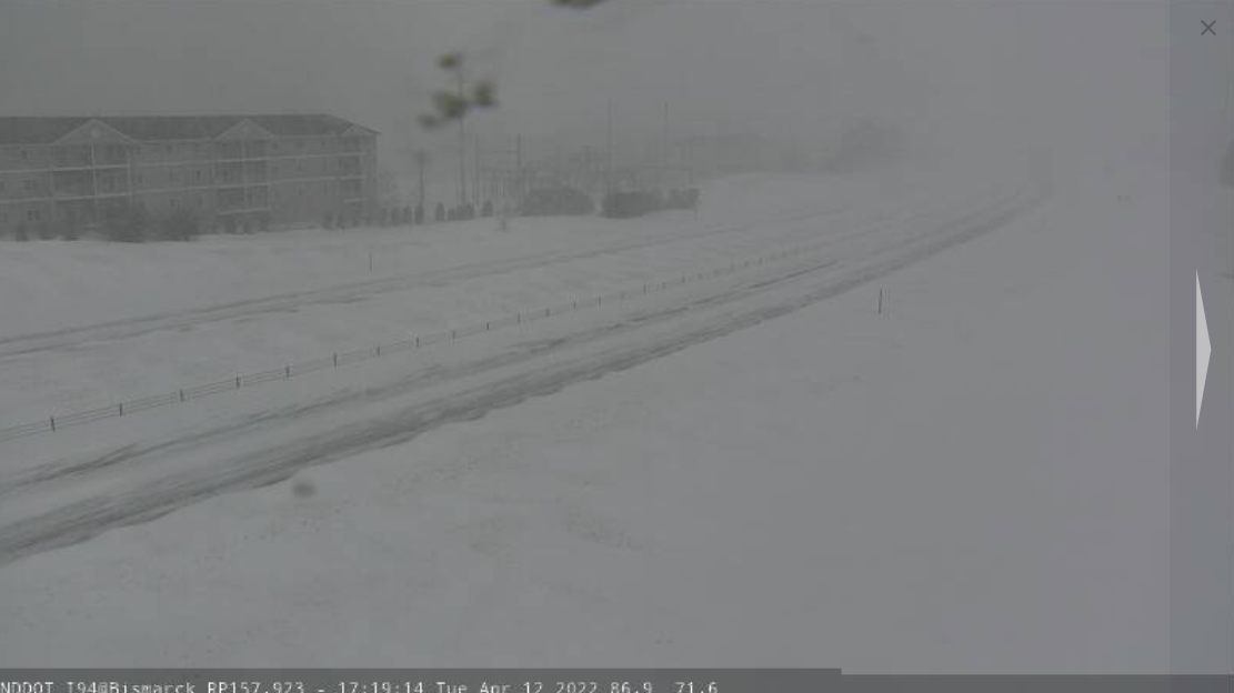
Seriously, there are some great live shots of the blizzard on NDDOT.
Yeah…Minot ND is expecting 24-30” of snow. An incredible storm.
-
 1
1
-
-
Point forecast for Minot ND…wow
This AfternoonSnow. The snow could be heavy at times. Widespread blowing snow. Steady temperature around 26. Windy, with a northeast wind around 26 mph, with gusts as high as 39 mph. Chance of precipitation is 100%. Total daytime snow accumulation of 7 to 11 inches possible.TonightSnow. The snow could be heavy at times. Widespread blowing snow. Low around 22. Windy, with a north wind 25 to 29 mph, with gusts as high as 43 mph. Chance of precipitation is 100%. New snow accumulation of 10 to 16 inches possible.WednesdaySnow. The snow could be heavy at times. Widespread blowing snow. High near 29. Windy, with a north wind 28 to 38 mph, with gusts as high as 55 mph. Chance of precipitation is 100%. New snow accumulation of 6 to 10 inches possible.Wednesday NightSnow. Widespread blowing snow, mainly between 9pm and 1am. Low around 19. Windy, with a northwest wind 28 to 34 mph, with gusts as high as 50 mph. Chance of precipitation is 90%.-
1
-
 1
1
-
-
Historic storm coming for parts of ND
 :
:
URGENT - WINTER WEATHER MESSAGE
National Weather Service Bismarck ND
228 PM CDT Mon Apr 11 2022

NDZ001>005-009>013-120400-
/O.CON.KBIS.BZ.W.0005.220413T0000Z-220415T0000Z/
Divide-Burke-Renville-Bottineau-Rolette-Williams-Mountrail-Ward-
McHenry-Pierce-
Including the cities of Parshall, Glenburn, Dunseith, Sherwood,
Minot, New Town, Columbus, Shell Valley, St. John, Portal,
Lignite, Rugby, Rolette, Drake, Towner, Velva, Mohall, Bowbells,
Rolla, Crosby, Powers Lake, Stanley, Williston, and Bottineau
228 PM CDT Mon Apr 11 2022

...BLIZZARD WARNING REMAINS IN EFFECT FROM 7 PM TUESDAY TO 7 PM CDT
THURSDAY...

* WHAT...Heavy snow and blizzard conditions expected. Total snow
  accumulations between 12 and 24 inches, with locally higher
  amounts up to 30 inches possible. Winds gusting as high as 50 mph.

* WHERE...Northwest and north central North Dakota.

* WHEN...From 7 PM Tuesday to 7 PM CDT Thursday.

* IMPACTS...Travel will become very difficult to impossible.
  Widespread blowing snow could significantly reduce visibility.

PRECAUTIONARY/PREPAREDNESS ACTIONS...

Travel should be restricted to emergencies only. If you must travel,
have a winter survival kit with you. Notify a friend or family
member of your travel plans. If you get stranded, stay with your
vehicle. The latest road conditions can be obtained by calling 5 1 1.
-
2
-
1
-
-
23 minutes ago, Hoosier said:
Things are going to be changing around here. Weatherbell/JB have been negotiating the purchase of American Weather, and my sources indicate that it is just about finalized.
April Fools (?)

-
On 3/27/2022 at 5:57 PM, Chinook said:
If you have a 33% chance to be above normal, do you have a 67% chance to be below normal? If you have a 33% chance to be below normal, do you have a 67% chance to be above normal? The logic of the portrayal of the outlooks has never made sense in the last 20 years.
No…the “default” is 33% chance below normal, 33% chance near normal, and 33% chance above normal.
So, an outlook of “40% probability of being below normal” is actually saying that there’s a slightly greater chance of being below normal vs. the default…since the default is only a 33% chance of being below normal.
The other interesting thing about these probabilistic outlooks is that they don’t tell you anything about *how much* above or below normal it’s projected to be. For example, if you see an outlook showing an 80% chance of being below normal on temps, it’s a strong signal that it will be colder than normal…but you don’t know if this means 5F below normal, or 25F below normal.
-
1
-
-
With 25" of snow on the ground, INL dropped to -8 this morning. A bit wintry for March 28th.
Ely hit -11.

Amazingly enough, INL has been even colder later in the season. Some examples below, with records going back to 1897. As expected, the April 1982 arctic outbreak shows up.
-21 on 3/31/1975 (!)
-14 on 4/3/1954
-12 on 4/2/1954
-11 on 4/6/1982
-9 on 4/7/1982
INL's latest sub-zero temp on record was 4/8/2018 (-3)...a good illustration of how anomalous 1982 was.
-
Thanks for posting this, Bo. That is beautifully written; humble poetry that captures a deep connection with nature.
-
14 hours ago, frostfern said:
Are there temperature weenies here? I think most of us only care about snow. Jan and Feb were consistently below freezing with fewer thaws than normal, but there weren't many extreme events. There was no brutal cold outbreak and the only major snow event was a localized lake effect event. Nothing memorable at all, despite being a typical cold winter.

On some level, cold and snow are linked...as you need a good amount of fresh snow cover imby and upstream to maximize the cold potential (whether advective or radiational).
While Jan and Feb were a bit below normal here (though still not truly cold), there was too little snow here to maximize the cold potential. We never had more than 3" on the ground at any point. And Dec was horrible; that month ruined winter here.
-
1 hour ago, Hoosier said:
Was thinking about beavis' comment about summer wx being more reliable in JJA in contrast to winter wx not being as reliable around Chicago. I think there's some merit to that. Think about it. Summer months and months that are adjacent to summer have a tighter range of temperature anomalies than what can occur in winter. It simply cannot get as far above or below average in summer. Around Chicago, a few degrees below average in summer still feels reasonably summer-like, but a few degrees above average in winter means you are probably going to start melting any snowcover that you have, and it has been a struggle to build up any decent snowcover this winter especially north/west of the city.
Chicago is better than a lot of other places for wintry wx, but it's still kind of living on the margins with not a whole lot of room for error.
Yeah - that's a good summary, imo.
It's getting at the idea that you can’t really have a meaningful winter season (landscape, frozen ponds, reliable snow cover, etc.) without cold. Actual liquid precip averages during the cold season really don’t matter that much in the end. Of course, more precip is better, all else being equal...but cold is the key.
The concept is “sacred” winter days. In other words, if you were dropped into a town on a specific calendar date (say Feb 5th), would you be able to count on the fact that it would look and feel like winter? There could be many definitions of this...but in my mind, it means a 90% chance of a high temp of 35F or lower AND 2”+ snow cover on a specific date. No anxiety about the weather pattern being a certain way, etc.; you just know it will be wintry outside, in line with what it’s supposed to be because the calendar says it’s winter.
Sure, you could have an anomalous pattern every so often (like March 2012)…which is why I am only using a 90% threshold instead of 100%.
Using this definition, nearly all non-mountainous locations in the lower 48 south of 44N have zero sacred winter calendar dates. There is a huge gradient of this metric across the upper Midwest…because far northern MN probably has close to 100 sacred winter calendar dates…whereas southern WI has zero. This is a great illustration of why I get so frustrated in winter here - because the gradient is so extreme, as the crow flies. So close, yet so far. But in some ways, the gradient is also good news - because hopefully those of us who want more sacred winter dates can move only a bit further north to get it. That's my plan when I hopefully retire from day-to-day work in the next 5 years.
Looking at sacred winter days in Chicago as an example - the coldest calendar dates in the year (mid-Jan) only have a 65% chance of a high temp 35F or colder. Adding the 2” snow cover condition reduces the % even more. So, it falls well short of the 90% threshold. And in early Feb, temps start warming up, even as there’s a somewhat higher chance of 2” snow cover…but then we just run out of time as the winter season fades away later in February.
This all reminds me of Jonger's post from several years ago, showing a loop of snow cover during several winters in a row...where it sort of "pulses" down to 40N, then back up to 45N, then back down to 40N, maybe 38N occasionally. But MBY (42.2N) is always on the edge, when you view a quick time-lapse of seasonal snowcover. The big exception is 1978-79...a 1-in-100+ year event where MBY had snow cover on 110 consecutive days, and Chicago had snowcover for 100 consecutive days.
Like you said, it's seasons in seasons - we can always count on essentially every calendar date in July and August (at a minimum) to be summerlike, but we can’t count on any specific calendar dates in winter to be winter-like. I actually like all seasons - I just want them to be equal in length.
") 90 days of sacred summer, and 90 days of sacred winter. And having highs in the 20s - 40s most days, with occasional snow cover, isn’t winter. Of course, everything is personal preference in the end.
90 days of sacred summer, and 90 days of sacred winter. And having highs in the 20s - 40s most days, with occasional snow cover, isn’t winter. Of course, everything is personal preference in the end.
You basically need average high temps in Jan to be 20-25F (and Dec & Feb with averages no warmer than 25-30F) in order to have a true wintry climate with consistent snow cover, in order to have a decent # of sacred winter calendar dates. That way, when you do get the occasional mild pattern, you don't torch (meaning no days over 40F). Unfortunately, Chicago's winter average temps are about 10 degrees too warm for that.
Not saying there needs to be 4 feet of snow on the ground...but a reliable 5-10+" would be nice during most of DJF. A White Christmas is key - but at ORD, I think it's only about a 40% probability.
-
^ Those are incredible stats. Wisconsin also set its all time record low back then…I believe it was -55 in Couderay.
-
3 hours ago, Brian D said:
-30's again away from the Lake with near record/record lows set yet again. Jan-Feb this year has seen some really cold morning lows away from the Lake with many being near record/record stuff. A healthy snowpack with strong high pressure allowing for calm morning conditions really does the trick.
Yeah...and INL dropped to -40 again...breaking yesterday's record for the coldest temp so late in the season.
Reminds me of the early Feb 1996 arctic outbreak, where the nights in northern MN were brutally cold but it warmed up quite a bit during the day. An even deeper snowpack back then (generally 30-40"), plus not as late in the season, plus the airmasses themselves were a bit colder. Some areas saw several nights of lows in the -40s to -50s.
-
26 minutes ago, Brian D said:
Very cold up here last night. That was the latest -40 reading record for I-Falls. Feb 20 had -44 for the latest -40 record before this morning. One more very bitter morning before more pleasant weather, yet still cold, starts this weekend. -20's is the forecast, but with very calm conditions slated for the a.m., probably will get a little colder, again, than the forecast. -30 was the forecast for this morning around those areas, and you can see how much colder it got.
Wow, very impressive.
-
45 minutes ago, madwx said:
hit -40 in International Falls this morning, so much cold bottled up just to our north. Will be nice to see that pushed out of the region this weekend
Good catch, was -39 on the hourlies but hit -40 intrahour.
Out of curiosity...why? Everyone here is jumping on the bandwagon for winter to end, when we haven't even had winter to begin with. We're all supposed to be kindred spirits on this forum, not like Joe Q. Public who hates winter. It used to be that way - but not anymore.
Seems like everyone here all of a sudden likes warm and comfortable weather, and doesn't like the cold. If it were constantly below zero, fine...but it hasn't been all that cold in an absolute sense. Let's all just live in FL, AZ, or HI and call it a day...
Not directed at you personally...but it just gets old. Tired of coming on to a winter weather forum and seeing posts hoping against winter weather.
I'm ecstatic about the cold in MN, but am furious that we can't get it down here for any prolonged period of time. It isn't even that cold of an airmass...but amazing what can happen when winter takes hold of an area...with deep snowpack and calm winds. You know, winter conditions in DJF - go figure. Kind of like summer conditions in JJA - which always happens with no worries.
The nights aren't even that short anymore up there, and it still hits -40. But everyone else wants the cold to go away, when we can't buy a frigid advective and/or calm morning here with deep snow cover if our life depended on it. It sucks. The last one was Jan 2019 - more than 3 years ago...but then it was 40F 2 days later...which ruined it.
And on top of that, everyone here is obsessed with removing the snow and ice as quickly as possible - to just erase it from the earth. Traffic, on the go, never-ending drift away from nature, blah blah. And we don't really get radiational cooling here anymore - too much urban development...and I'm like 25 miles NW of the Chicago core. It's even worse closer in.
This is very personal for me...as I gave up forecasting after getting a met degree, because I realized that I don't care about getting a forecast right. I only care about the outcome, especially in winter. I don't go around hoping for cold weather in August, pissing on everyone's summer fetish cheerios.
If we actually had a winter here, I'd be more willing for it to end, especially as we get into mid-March. But when we don't have winter, there's a desire to make up for it later in the season....and then we never catch up and the season slips away...again and again and again.
Everyone can just put me on ignore - who gives a fook anymore.
-
Low temps in MN this morning...I'm sure these are close to all-time record lows for so late in the season:
International Falls -40F (old record -31F in 1917); 25" snow depth
Ely -38F
Cook -38F
Orr -36F
Bigfork -36F
Hibbing -35F (old record -33F in 1965)
Bemidji -34F
Duluth -13F; 22" snow depth
-
1
-
-
20 minutes ago, Hoosier said:
I knew it was bad in the northwest suburbs and up toward MKE, but didn't realize just how sluggish it's been. The total snow to date at RFD is the lowest since 2002-03.
The seasonal snowfall totals in some of those areas actually mask how bad it has been, believe it or not.
My brother lives in the northern suburbs of MKE, and they have 10” of snow for the season so far. As bad as that is, all of the snow has been DABs to 2” at a time. Depth hasn’t exceeded 2” there all season, and most days the depth has been 0-T. It’s incredibly and horribly pathetic…no sugar coating it.
-
 1
1
-
-
9 minutes ago, ValpoVike said:
Well, Colorado isn't Chicago and our winters feature snow with cold (but reasonable) temperatures. It's what you're used to and of course a matter of personal preference. I left NW Indiana 7 years ago and never looked back, largely due to the long stretches of sub-zero cold and the relentless cloud cover. But I digress.
Interesting that you think Chicago and NW IN have cold winters.
My whole point was that their winters aren't nearly cold enough - and this is because you can't count on snow on the ground throughout most of DJF. You basically need average high temps in Jan to be 20-25F (and Dec & Feb with averages no warmer than 25-30F) in order to have a true wintry climate with consistent snow cover. That way, when you do get the occasional mild pattern, you don't torch (meaning no days over 40F).
Not saying there needs to be 4 feet of snow on the ground...but a reliable 5-10+" would be nice during most of DJF. You know - Currier and Ives scenes, White Christmas, frozen lakes, etc.
Unfortunately, Chicago's winter temps are about 10 degrees too warm for that.

Also, I wouldn't say we have "long stretches of sub-zero cold". Chicago only averages about 7 days each winter with low temps below zero.
Yes, I agree that it's all personal preference...but it just surprises me that people on a (mainly) winter weather forum seem to prefer mild/warm/hot weather over cold weather. It's frustrating for me personally because I hope to find kindred spirits on this forum...knowing that most of the general public hates winter.
-
1
-
-
2 hours ago, mayjawintastawm said:
I think I have not encountered this prolonged cold, cloudy, light snow type of thing in my 11 years in Colorado. It's been below 10 F for almost 48 hours and we've had 1.4" of styrofoam snow with vanishingly small water equivalent. Even the dogs don't want to spend more than a few minutes outside. Good for ice reinforcement on the lake but not much else.
Not directed at you…but I have always found it interesting that a lot of people on this forum (in various regions) want snow, but not cold. I would understand this among the general public, but it’s strange on this forum since most people here look forward to winter.
But to me, you can’t really have a meaningful winter season (landscape, frozen ponds, reliable snow cover, etc.) without cold. Actual liquid precip averages during the cold season really don’t matter that much in the end.
I’m thinking of making a post in the Lakes/OV forum about the concept of “sacred” winter days. In other words, if you were dropped into a town on a specific calendar date (say Feb 5th), would you be able to count on the fact that it would look and feel like winter? This means a 90% chance of a high temp of 35F or lower AND 2”+ snow cover on a specific date. No anxiety about the weather pattern being a certain way, etc.; you just know it will be wintry outside, in line with what it’s supposed to be because the calendar says it’s winter!
Sure, you could have an anomalous pattern every so often (like March 2012)…which is why I am only using a 90% threshold instead of 100%.
Sadly, nearly all non-mountainous locations in the lower 48 south of 44N have zero sacred winter calendar dates! There is a huge gradient of this metric across the upper Midwest…as far northern MN probably has close to 100 sacred winter calendar dates…whereas southern WI has zero.
For example - in Chicago, the coldest calendar dates in the year (mid-Jan) only have a 65% chance of a high temp 35F or colder. Adding the 2” snow cover condition reduces the % even more. So, it falls well short of the 90% threshold. And in early Feb, temps start warming up, even as there’s a somewhat higher chance of 2” snow cover…but then we just run out of time as the winter season fades away later in February.
For a winter lover (not just individual storms, but the tenor of the season) living in areas with more plentiful job prospects, it’s difficult and sad to accept. I like seasons in seasons - we can always count on July and August (at a minimum) to be summerlike, but we can’t count on any dates in winter to be winter-like. And highs in the 30s and 40s with bare ground isn’t winter, no matter what some believe.
-
2
-
-
This is a perfect AFD - from Grand Forks ND. It's good because they accept winter and that's just how it is - not like us in the tropics where everyone freaks out if wind chills are sub-zero or if there's a bit of snow. It's comical, really, how we overreact to the most minor wintry conditions down here...in winter.
The best part is being excited about getting some relief, because wind chills are only in the -30s instead of the -40s.
Area Forecast Discussion
National Weather Service Grand Forks ND
648 AM CST Wed Feb 23 2022

.UPDATE...
Issued at 645 AM CST Wed Feb 23 2022

Batch of high clouds exiting eastern ND into northern MN at 12z.
Otherwise clear, temps -15 to -30F. Winds are pretty light and
keeping most wind chills in the -30s instead of -40s. But not
going to split hairs and will keep the WC warning out as winds
should increase 1-3 kts after sunrise and temps slow to warm.

&&

.SHORT TERM...(Today through Thursday)
Issued at 242 AM CST Wed Feb 23 2022

A quiet short term period, which we haven't had in quite a while.
High pressure will be moving slowly east and be over the area
tonight into Thursday as winds continue to lighten. Cold airmass
under the high will remain in place, though it will get slowly
modified over the coming couple days. Winds early this morning are
quite light over NE ND and NW MN (5 kts or less) and thus wind
chills are not too extreme mostly -20s and -30s. As temps drop
more thru daybreak still a chance they get into warning wind
chill range, but overall not as bad as this time yesterday.
-
1
-
-
59 minutes ago, Baum said:
His call was 0 from 5 days ago. He should be dancing given him shows him getting 3". Lesson for all; set your expectations low and you won't be disappointed. Oddly, that 18Z looks better for areas further NW in Chicago metro.
Doesn’t matter what people’s calls or forecasts are. Only the end result is important. I’d love for everyone on this board to forecast 2” on a storm sometime, and bust horribly…and we end up with a surprise 15”.
-
1
-
-
50 minutes ago, Thundersnow12 said:
How are either of this caving to a weaker/drier solution?
Verbatim, the 0z GFS had a max of 25” in McHenry County. 6z is only 10-15” there…and the max a bit further south is much less than 25”.
All relative…
-
^ Great list Bo. For future reference, do you have a link to the source data? I can usually find UP snow depths pretty easily, but not seasonal snow totals.
Hard to believe Iron Mountain’s snowfall has been so low…but still a ways to go in the season for them. Either way, good snow cover and cold up there.
-
2 hours ago, Baum said:
love it. On days with no precip feels so much better out and the added heat energy going to fuel even the clippers on the cold side.
Ugh. Why is everyone so excited to be done with winter…especially when we haven’t even had much of a winter here this season to begin with? It’s only 2/8. Do people want summer to be over by 8/8?
It’s bad enough that I have to deal with anxiety about today’s 40F temps eating away at the modest snow cover…and desperately wishing for the sun to go away. But then it’s even worse that others are actively rooting for this, and excited about the sun angle and dampness/warmth in the air as the inevitable end of winter occurs. Fine - but can’t it wait until 2/28??
Winter is not supposed to be comfortable or feel nice. People are supposed to be crying and begging for warmth and relief from bitter cold and snow.
Maybe we should all live in international falls for a winter or two, to experience what winter should actually be like.
-
1
-
-
A bit chilly in northern Alaska...Deadhorse had a wind chill of -84F at 9AM local time this morning (temp -51F, SW wind 14 mph). Yikes.
-
11 minutes ago, Chicago916 said:
I was talking about the 21Z which is even better and obviously doesn't cover the main event. Plumes are terrible though at long range, so just watching how they trend.
Yep, just realized that - edited my post to summarize 21z. And I agree it’s more about the trends with SREF plumes, not so much the actual numbers.
Winter 2021-22 Complaint/Banter Thread
in Lakes/Ohio Valley
Posted
Looks like much of ND ended up with 18-30" of snow. Highest report so far is Glenburn at 30.5", with 3 NNW Minot at 30"...and it's still snowing.
Record low max temps could be shattered tomorrow, and record lows could be shattered on Saturday morning. Here is Bismarck, as an example:
- 4/15 record low max 32, set in 2011; forecast high 25
- 4/16 record low 10, set in 1953; forecast low 7