

wx2fish
-
Posts
2,297 -
Joined
-
Last visited
Content Type
Profiles
Blogs
Forums
American Weather
Media Demo
Store
Gallery
Posts posted by wx2fish
-
-
8 minutes ago, ORH_wxman said:
I’m more impressed with BOS sustained winds at 43 knots than the 59 knot gust.
Looks like it just sustained it again on the last 5 min ob. Might be able to pop another big gust
-
14 minutes ago, TauntonBlizzard2013 said:
Peak gust of 32 here. Zzz
G50kt TAN
-
8 minutes ago, powderfreak said:
I’m not sure what it is there, but I find those night live cams make rain look like snow. Easily fooled on those cams, but looks like flakes either way.
Yeah I can't tell on my cams at home alot of the time. Seems like some frozen mixed in there, but hard to tell for sure. 35-36 and slowly dropping on the meso stations nearby
-
17 minutes ago, MBRI said:
Flakes at Lopstick in the Burg
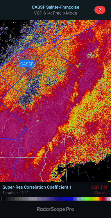
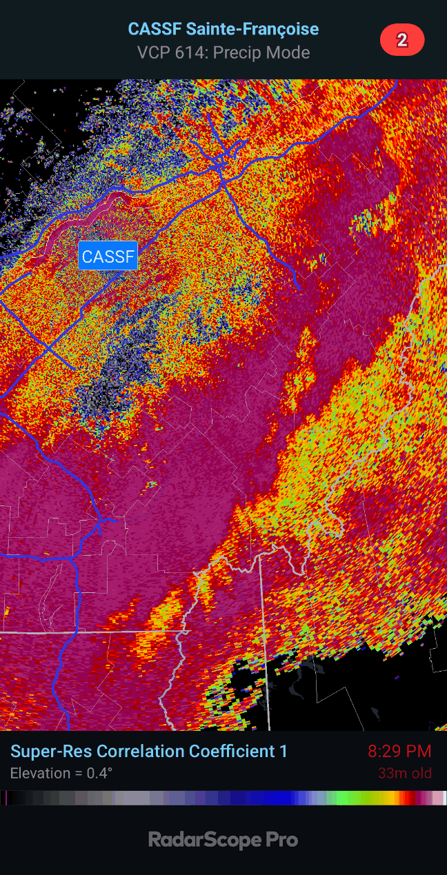
Looks like the mid level freezing line is getting close on CASSF
-
11 minutes ago, dryslot said:
12z Nam slashed qpf for the areas that snow too in VT, NNH and NW ME.
Could be quite the gradient across NW ME. Trends this morning give Coos Co a little more wiggle room and start to get more of NW Maine in the game
-
Just now, dendrite said:
Congrats Scoot
That LLJ is nuts. Some low topped convection ripping through around 15z, probably would help mix it down in spots
-
 1
1
-
-
That is some wild qpf on the 0z nam and hrrr
-
1
-
-
1 minute ago, ORH_wxman said:
18z NAM went east again....gets western SNE into accumulating snow.
@RUNNAWAYICEBERGdoing naked snow angels while me and Ray get rained on?
I'd take that LLJ on the backside. Best shot at wind inland.
-
28 minutes ago, dryslot said:
12z GFS with another move further east with the FROPA on the 10th, NNE could see some snow now out of this, 12z CMC has it too.
Brutal wedge Sat north of the pike that run. Wouldn't surprise me if you Dendy don't mix out until fropa.
-
3
-
-
4 minutes ago, brooklynwx99 said:
pretty favorable trend in the Pacific mid-month... PNA looks much better. might be able to pull off a light event given this pattern

18z op went wild with the NAO in weenie range. Probably wrong, but it would be one way to keep things a little more interesting.
-
2
-
-
13 minutes ago, Chrisrotary12 said:
Pellets mixing in here.
Same here, sleet and catpaws. Temp steadily dropping. May have a brief window to flip over the next hour or 2.
-
@NHDrySlot Flipped to sloppy Snow in Bedford. So, the snow line isn't too far N&W of MHT
-
3
-
-
One of the biggest Dec storms on record for the MHT area was Dec 1-3, 2019. Don't have to go back to the knicker days to find one
-
1
-
-
20 minutes ago, CoastalWx said:
EPS says goodbye.
Poor kids lost a couple presents when you scrolled through the 11-15 day
-
 3
3
-
-
21 minutes ago, weatherwiz said:
Looks like the 18z NAM coming onboard for Sun into Mon too
Pretty chilly look at the sfc late Sunday, CF would be down into interior MA. Still trying to fight off some warmth around 925 though.
-
38 minutes ago, Lava Rock said:
how much?
39.3" so far. Actually got most of it in the first 2-3 weeks of the month.
-
 1
1
-
-
1 hour ago, dryslot said:
I found that very suspect, Pittsburgh only had 2"
Im sure it had a big elevation gradient, but looked like 3-4" on the lopstick webcam above the 1st Lake
-
1
-
-
5 hours ago, Damage In Tolland said:
Almost always works . If AK is cold and snowy, we generally will not be . AK is cold and snowy now into Dec
Snowiest Nov on record for Anchorage. Ironically, they are +3.0F mtd
-
8 minutes ago, 40/70 Benchmark said:
Of course it did....about 5 mi to my NW....I joking said to someone that I would be just SE of the "bad" snow

It snowed here for a few hours, but I only had a coating left when I woke up. Similar gradient to last winter across the northern part of town. This one had a little more longitude too I think due to the east winds.
Blasted up to 45 here now, while ash is still wedged.
-
1
-
-
3 hours ago, ORH_wxman said:
Guidance pushed the core of the cold to the following week and then lingering into early December whereas about 4-5 days ago, it looked like the core of the cold was Tday weekend with potentially eroding cold late the following week.
I know your post is more on the troll-y side but just posting this for those who are interested in the evolution of the changes rather than one-liners.
Sat looks pretty cold now, good delivery (esp euro). If the trough doesn't lift out too fast there's a decent shot at sub-freezing highs into interior SNE.
-
1
-
-
7 minutes ago, qg_omega said:
CMC and Euro FTW
12z CMC has a secondary going under NE now. End result is gonna be a colder rain regardless though
-
19 minutes ago, Torch Tiger said:
I really want everything down for turkey day, powerhouse screamer, but it's unlikely
Yeah we'd all take some damage, but I'd bet on a triple point or secondary to invert most away from the coast.
-
2
-
-
Looks like the euro is finally coming in. Almost got 2 full gfs runs before the euro
-
1
-
-
7 minutes ago, dendrite said:
I saw some skeeters
Saw some bees and spiders kicking around too. Low of 30 this morning too
December 2023
in New England
Posted
The East and especially NE has furnaced over the past several years relative to the Plains/West in DJF. My guess is there is a regression to the background warming trend at some point.