

wx2fish
-
Posts
2,298 -
Joined
-
Last visited
Content Type
Profiles
Blogs
Forums
American Weather
Media Demo
Store
Gallery
Posts posted by wx2fish
-
-
Off and on showers all afternoon with a few sunny breaks. String of meh continues
-
 1
1
-
-
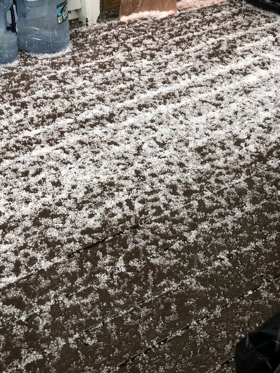
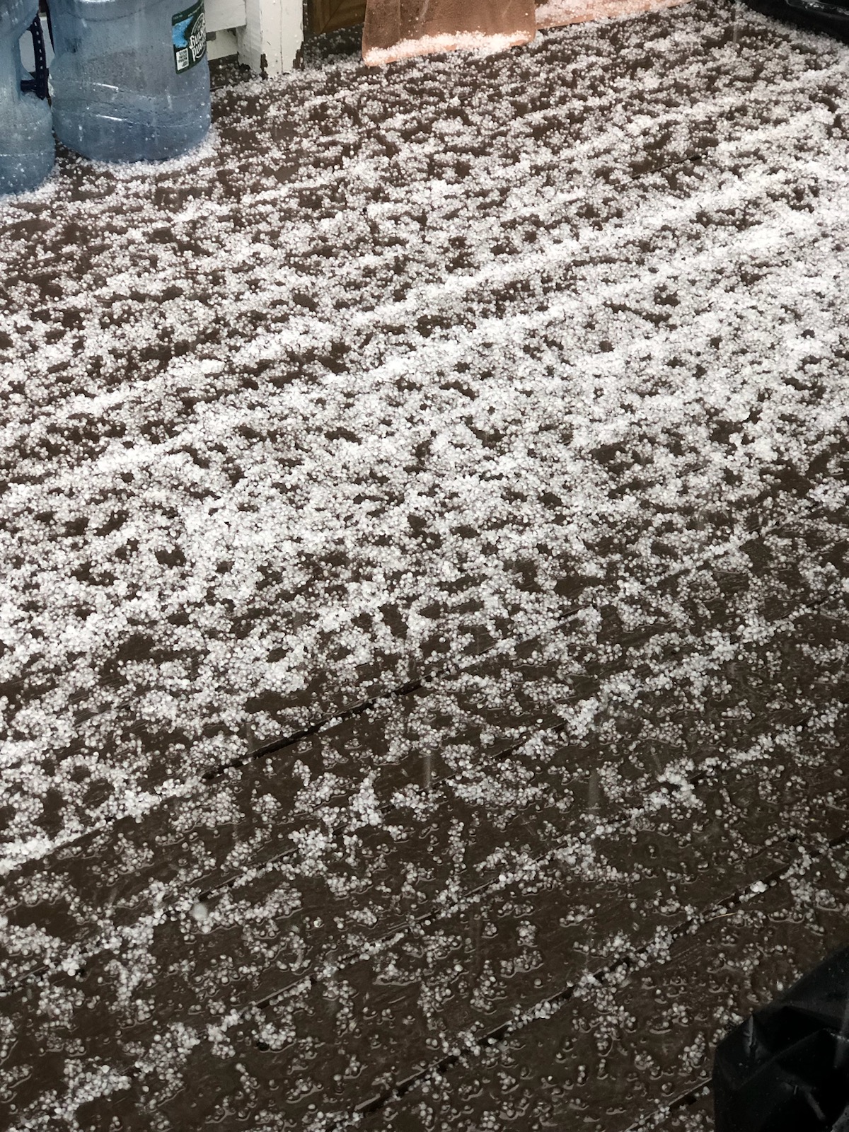
Small peas, but lots of them. I was on 28 in Salem a little while ago and it was already covered with a few inches of water in spots.
-
2
-
-
Hit 52 briefly, but down to 48 and light rain now. Brutal
-
55 minutes ago, Typhoon Tip said:
Not to be too priggish but ... it was really more of a 'hybrid front.' More of a backdoor phenomenon down the coast S of here - if that makes any sense.
Typically ( for the general reader ... ) the S/W cuts SE out of E Quebec ... more often times, barely denting the non-hydrostatic gradient over us ... as it sweeps past up there. The front that results beneath really doesn't look physically like it should even be there.
But that's when/where our local geography dooms us...
Typically there is a NW flow type at mid levels as the above S/W slips past. That is flow is lifted over the Dacks/Greens/Whites general massif ... and than passes as an elevated wind max that becomes slightly imbalanced in the lower elevation nadir east of said elevations ... as that lower eastern region fades to sea level (where cold Labradorian water mass and cool dense slab of air is just aching for a reason to move west ...)
That induces a vector pointing back SW or W ...
Now imagine if the above S/W in our example triggered a front to move back SW. That happens everywhere, anyway ... These fronts have a backward wash momentum - it's just a matter of how much so. Just look at the current sfc layout from WPC this hour, and it's trying to move SW toward Michigan ( the main frontal axis). But if we superimpose that type of momentum over the top of the above geographic/geo restoring tendency, that's what drills the "real" BD scenario. It's really more of a "meso beta scaled" event, as the synoptics are smaller then continental and confined to just our region ..etc ... where the "pure" BD mechanics create the momentum.
This thing is tied into a wholesale mass-field jolt retrograde - actually one of the faster I can recall - different conversation. This was more a straight N-S cold front that would have overwhelmed all those other mechanics. But I think of it as a hybrid, because it is shallowing out ... and will end up being a BD down toward the mid Atlantic.
Either way... 93 to 53 is a straight 40 point correction in 24 hours. It's a whopper synopstic ordeal. Evidence of this latter can be seen in guidance, where this thing isn't a one an done thing. They're trying set up a 10 days pattern with this cold local hemisphere anomaly.
Agree that it's kinda of a hybrid, not just a shallow pool of cold air surging south. Temp is still dropping heading into midday, 49F.
-
Temp still tickling down some. 50F. Ended up a pretty high end door off a 91F high yesterday. Well see if we recover at all later this afternoon.
-
47 minutes ago, dendrite said:
MAM
I'd have to go tally them up but I feel like inland we've had several 40+ diurnals over the past 3 months. It's been a pretty solid rad stretch
-
21 minutes ago, CoastalWx said:
Going to shit
Couldn't draw it up much worse than that euro run. Struggling to hit 50 on Sunday with firehouse Phil into Weymouth
-
1
-
 1
1
-
-
Tip approved backdoor next Sat on the gfs. Hopefully we can moderate that.
-
1
-
1
-
-
4 hours ago, PowderBeard said:
It's been too good in Maine. So many big fish this year. Won a tournament on Sebago at the end of April with 5 for 22+ lbs. I had a 6.2, a 5.5, some 4+, and then one damn 2 pound fish I could not cull out. I lost two over 4 lbs that day too. A co-angler actually took big fish that day with a 6.70 largie. There were many smallies over 4 lbs weighed in too. I stuck to targeting shallow largemouth because it was my first time there and didn't have time to go looking for the off-shore smallies prior to the tournament.

Starting to see beds everywhere though. Next tourney is not until June on Moose Pond.
Nice! Heck of a bag. I havent been out much, but I won a small club tourny on Merrymeeting with 4 smallies for 17.5lb. Been a good spring for big ones.
-
2
-
-
Noticed some of the roadside invasive stuff (some kind of bamboo I think) looks completely toasted after last night
-
1
-
-
Low of 28. Coldest May temp since I set up my Davis in 2017.
-
1 hour ago, powderfreak said:
Wednesday afternoon is looking pretty chilly. NAM has early highs in the mid-50s for most of SNE, but then the max temps from 2pm - 8pm (18z-00z) are cool.
Max in the low 40s up here all day.
That's a pretty chilly airmass. 850s getting down around -8/-9 up there. Maybe you can grab a little uplsope.
-
4 minutes ago, CoastalWx said:
43 and ocnl shwrs. Awful.
Seasons in seasons
-
1
-
2
-
-
56 minutes ago, Torch Tiger said:
I am talking about 5/1, says 64. That's BN?
[TEMPERATURE DATA] [PRECIPITATION DATA] SYMBOLS USED IN COLUMN 16
AVERAGE MONTHLY: 55.3 TOTAL FOR MONTH: 0.21 1 = FOG OR MIST
DPTR FM NORMAL: 1.3 DPTR FM NORMAL: -0.01 2 = FOG REDUCING VISIBILITY
HIGHEST: 64 ON 1 GRTST 24HR 1.11 ON 30- 1 TO 1/4 MILE OR LESS
LOWEST: 47 ON 2 3 = THUNDERI was referencing the avg high/low for 5/2, but yeah 64 should be slightly AN on the high for BOS.
-
7 minutes ago, Torch Tiger said:
Is 64 a BN high for KBOS on 5/1? I thought they were like 62
Looks like 63/46 on yesterday's climo report for 5/2
-
1
-
-
3 hours ago, CoastalWx said:
ORH *
Yeah Boston is +2.5 going into today, although HFD is running closer to ORH. Best +'s seem to be west and southwest
-
55 minutes ago, SouthCoastMA said:
Ticks are out - early
I found a couple when we still had patches of snow otg in March. Incredibly hardy suckers
-
2
-
-
That is one ugly gfs run.
-
11 minutes ago, CoastalWx said:
I've just never heard this being a thing, so I'm surprised people getting vaxed for it. A flu or covid vax etc I get.
It can pop up in people who had mild case of chicken pox, but not the vaccine. I had a very mild case of shingles a few years ago when I was in my 20s, and my brother just did around 30. I think we're more agressive with the chicken pox vax today in kids than back in the 90s.
-
1
-
-
Just had some grapuel mix in with the latest shower rolling though
-
2
-
-
12 minutes ago, Damage In Tolland said:
Mild look here right into May
Not a great look for those who've installed, but well hope for changes.
-
1
-
2
-
 1
1
-
-
Ensembles look pretty crappy by late month
-
1
-
-
5 minutes ago, Chrisrotary12 said:
Wind boundary went through here and the temp kept rising. Boo! Where's my refreshing breeze?
Down to 80F here to the east. Really nice out, glad it hasn't been a violent drop
-
Hit 88, but slipping back now with ese winds. 82 on the Davis

June 2023 Summer Begins
in New England
Posted
Never broke out today. Got within a few miles of clearing, but now it looks like the stratus is pushing back southwest some. Hate to see it