

wx2fish
-
Posts
2,297 -
Joined
-
Last visited
Content Type
Profiles
Blogs
Forums
American Weather
Media Demo
Store
Gallery
Posts posted by wx2fish
-
-
16 minutes ago, brooklynwx99 said:
yes, the antecedent airmass is terrible, which is why a slower storm is better. colder air would rush in from the northern stream
Yeah this run is much slower. Even BOS is pushing upper teens when it's stops snowing
-
 1
1
-
-
17 minutes ago, 40/70 Benchmark said:
I think I am about normal, too, at 24".
Hudson coop avg is 28" ytd. Not a super long period of record but Im usually within a few inches of their totals seasonally. So, I've slipped back a few inches. 23.3" ytd here.
-
2
-
-
Gfs actually doesn't look terrible Tues night for a couple inches. Still full on wedge the rest of the week
-
6 minutes ago, ORH_wxman said:
Euro wasn’t very enthused for Tuesday night/early Wednesday. There’s enough cold initially but not much precip. Maybe only an inch or two.
Pretty gross run for most of the week. Cloudy and wedged for days. Hopefully we can trend qpf up Tues night
-
3
-
-
Euro looked better than gfs for the early week stuff. Gfs going weenie beyond that toward the weekend
-
1
-
-
1 minute ago, 40/70 Benchmark said:
Its a combo piece....CC, poor multi decadal Pacific background and bad luck.
-PDO has had a role in this sub par stretch imo
-
3
-
-
18 minutes ago, 40/70 Benchmark said:
I have seen plenty of SWFE patterns that favored from around the pike points northward and even I 84...just depends and if there is ever a time for cold to get the jump climo wise, its these next few weeks.
Atleast we have high pressure and cold in Quebec modeled. Doesnt have to always be perfect to snow, esp with latitude. Unlike many of the setups the past 2 years, next week won't have a 970 stemwinder over DTW and a high over Bermuda
-
2
-
-
Another monster high late week on this gfs run. Hopwfully we can keep things interesting.
-
5
-
-
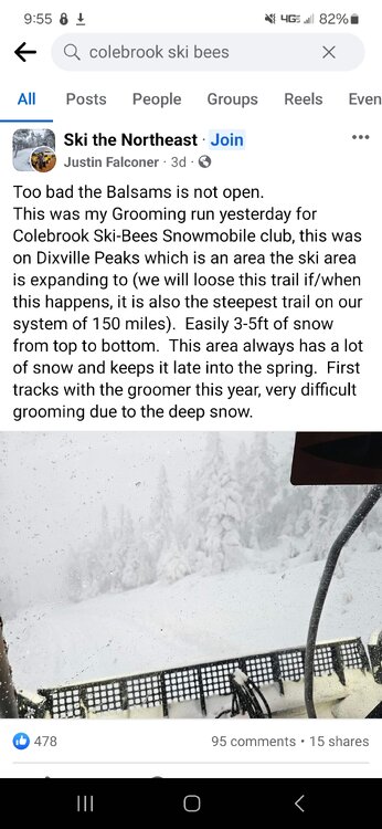
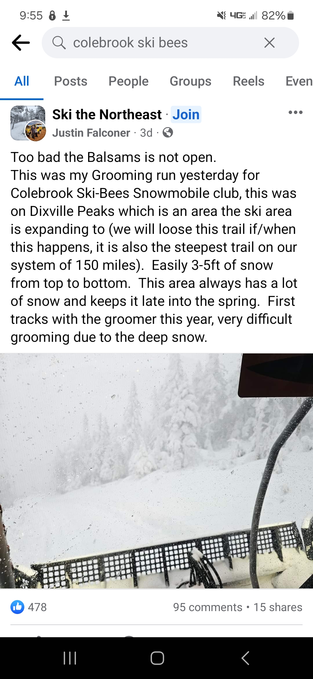
Despite all the big plans I wonder if they will ever get Balsoms open again. It would easily be the snowiest resort in NH, and up there for NE
-
1
-
-
5 minutes ago, mreaves said:
Wow, who’d a thunk the Allagash was a snow hole?
I think its more a lack of observations up there. That data set always seems to be low in NW ME, even on the daily time scales. Same for the non downslope areas of NNH.
-
3
-
-
34 minutes ago, 40/70 Benchmark said:
Yea, I'm not too worried about February, just speaking of the balance of January....the pattern should flip back by the end of the month. January has been pretty good in my area, but kind of disappointing on a regional level. I expected the coast to struggle, but I thought that they would have more than this.
For the strip from your area up to me it could be alot worse. Temps and cutters have sucked, but we are within a couple inches of normal snow year to date now, despite punting Dec. One big event can skew things quite a bit
-
3.8" combined snow/sleet with some freezing drizzle on top.
-
1
-
-
7 minutes ago, STILL N OF PIKE said:
Where is that mix line for NH friends
I'm not far from exit on 3 on 93 and keeps going back and forth depending on intensity, more snow now with a heavy echo.
Seems to have stalled out, and may be nearing it's northernmost point. Might have one more push, but nam maxed out around 4pm.
-
Primarily sleet and snow grains for the past half hour with some flakes in the heavier echoes
-
4 minutes ago, 40/70 Benchmark said:
Judging from RAD it just flipped at home.
~3.5" here. Still snow, looks close on CC. Hrrr stalls it out, but its been too far south with its progression
-
1
-
-
~3/4". Last 2 runs of the hrrr ramped up qpf from late morning through the afternoon
-
2 minutes ago, ineedsnow said:
I'll take the GFS
Juiced up again. Tosses 0.5" qpf back to about 495
-
1
-
-
Couple rounds here for just under an inch. Solid squalls
-
2
-
-
38 minutes ago, dendrite said:
Good post.
The hires models have been a little extra interesting. 6z 3k had a little mesolow going through SNE and the 6z weenie extended HRRR actually turned it into a coastal for E ME.
But yeah those TTs are always a good sign. This was a weenie forecast sounding from one of the squall lines over my head. Classic windex look.
12z hrrr is a mini blizz for downeast ME again after the meso rolls through SNH
-
1
-
-
1 hour ago, CoastalWx said:
Anybody looking at winds late Sunday morning and afternoon?
Definitely a window when winds go SW we could see some better mixing, especially south of the Pike and across E MA. That same window has 55-60F potential with lingering warmth aloft before the CAA starts cranking.
Winds could end up stronger on Sunday with deep mixing, but I guess that's really not for this thread.
-
1
-
-
6 minutes ago, CoastalWx said:
Wind might get close here. Rain nowhere near the last one. Maine coast is the biggest issue. Down to Hampton too. I'm talking flooding.
Maybe along the immediate coast and cape we can get some wind. Looks real wedged inland, esp north of the pike. Might even have some backing of sfc winds more ene. Breezy and warm afternoon behind the front though.
-
Flipping to sleet. 1.6" will do it
-
2
-
-
17 minutes ago, HoarfrostHubb said:
Well, the Pivotal clown does drop 6-7" as snow on the 10:1 for his backyard, but I would sell that
Your area looks good, although I can't see the soundings there (and can barely understand them)
Euro soundings for north ORH Co look like snow through 02-03z, maybe 04z on the border. So, maybe 0.3"-0.5" qpf. I'm still on the skeptical side, but its been fairly consistent.
-
3
-
-
25 minutes ago, weatherwiz said:
Pretty much all guidance is a widespread 2-3'' of rain across an extensive area. Some of the mesos are spitting out strips of 3-4''. Based on the likelihood that there will be convective elements, plus some orographic influences, degree of lift, I think there will be some pockets of higher totals.
It's pretty wild to see how widespread the rainfall totals are on all guidance. The wind signal too is quite concerning, though very uncertain. But I think we are going to see significant flooding and not just localized.
12z stuff definitely likes CT for the higher rain totals
-
1
-
January 2024 -- Discussion
in New England
Posted
Nice. Hopefully melt it off today. Hrrr and nam are real close to flipping your area over to snow tomorrow.
Looks pretty crappy right into sat. Could even see some fzdz down here and into the orh hills sat am.