

wx2fish
-
Posts
2,297 -
Joined
-
Last visited
Content Type
Profiles
Blogs
Forums
American Weather
Media Demo
Store
Gallery
Posts posted by wx2fish
-
-
4 minutes ago, CoastalWx said:
Nam sucks.
Looks pretty juicy for Wey in the end. Have to sell it at this point though
-
6 minutes ago, CTWeatherFreak said:
It's a little unsettling that Uncle hasnt budged.
Almost cirrus to ORH at 12z, pretty wild differences
-
 1
1
-
-
Just now, ORH_wxman said:
Here's HREF QPF on the 12z run...looks kind of like the NAM though maybe a tiny tick S.
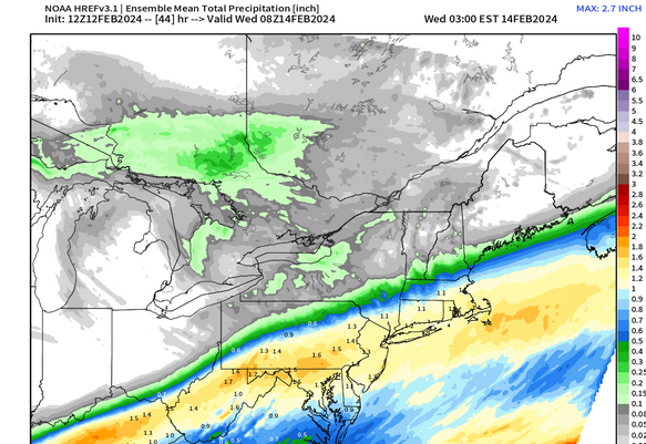
Back to that earlier discussion. Qpf looks less wild than the snowmap on SPCs site
.thumb.png.f4df0a7847ee4d9e2fcf3956dab36bba.png)
-
 1
1
-
-
Three of them in rapid succession on the gfs. Hopefully we can beef up one of them with a little inflow
-
3
-
-
2 minutes ago, CoastalWx said:
N/M, similar position, but more juiced.
Definitely better qpf for most areas
-
11 minutes ago, ORH_wxman said:
I've become more and more disillusioned with clown maps...they are lazy and often too wrong...looking at mid-levels and soundings is way better.
Even just qpf maps are more valuable most of the time. Unfortunately, its rampant in the field now across the field now
-
1
-
-
3k looks like a little bump north from 6z with the precip shield. What a hard call on the northside, esp MA/NH border and NE MA area. Nam and hrrr make it easier to discount the euro, were 6hr closer within 24hr now, but the stakes are high.
-
Much better for SNE this run
-
1
-
-
Thats a real juicy run for most
-
2
-
-
Right or wrong, the gfs has been fairly consistent over the past few cycles. Some wobbles, but no huge changes
-
2
-
-
9 minutes ago, mahk_webstah said:
Did the euro trend in any direction?
6z euro looked better to me for your area. Probably around 1/2" qpf
-
1
-
1
-
-
1 minute ago, jbenedet said:
NAM and GFS thermals continue to suck. Cold Bias beware.
NAM never had breaking 40.
Not sure it'll mean much, if anything with this system, but toss the nam far and wide today and tomorrow. It's off the rails, not mixing the BL at all
-
19 minutes ago, Layman said:
Has anyone seen the sun yet today? I thought we were heading for high 40's at some point.
The sun shone for a few minutes this morning before the front came through, clouded everything up and here we sit - overcast and 36.
Clearing pretty quick now from west to east. Plenty of sun here on the otherside of Rockingham Co now
-
1
-
-
35 minutes ago, HoarfrostHubb said:
Not that it means anything, but the Wunderground app is 6-12” for my hood Monday night into Tuesday. Timing wouldn’t be ideal for me. I’m guessing it is plugged into the GFS.
That data is a dynamic blend of globals and ensembles at that range. It gets a good deal of met attention in the shorter range, but its mostly automated that far out. The same data goes into the TWC app
-
1
-
1
-
-
Hopefully that weak system coming out of NY doesnt throw a wrench in sat afternoon temps. Euro is slower and really mixes things out, but the gfs and nam are quicker with the clouds/showers.
-
 1
1
-
-
10 minutes ago, 40/70 Benchmark said:
Wow, they average that much? More than I had thought...
Yeah me too. I didn't dive into any data on ECs site though, just a quick google search.
-
1
-
-
9 minutes ago, 40/70 Benchmark said:
What is Sydney NS climo? I'm sure they average more than Boston and are prone to larger storms, but that is still nuts. I'm just overwhelmed with emotion because on the one hand, I hate that city because I am jealous, and on the other hand it gives me weenie lust for what is possible in a warming climate.
I did a quick search the other day because I was curious. From what I found, around 110".
-
22 minutes ago, CoastalWx said:
June has had some cool periods last two years, but has been warm overall.
Yeah last year May,June, Aug were BN at MHT. We just furnaced the winter months. I'm hoping for AN with normal precip. We don't need a repeat of last year.
-
1
-
-
36 minutes ago, dendrite said:
West flow and >0c 850s. It’s a torch.
Euro would be a furnace Fri and Sat. Pound the over on 2mts with that look.
-
3
-
1
-
-
14 minutes ago, powderfreak said:
We just went +8.1F locally at MVL in January… Saint Johnsbury (1V4) with a period of record to 1800s was also +8.1F.
SLK at +7.2F… BTV +6.1 (less reliant on mins).
It turned into a +6 to +8 above normal January here. Thats pretty high-end to have temps of 30.2/17.4 for a mean up here.
Down here Jan went +4 to +5 at CON/MHT and last year ran +8.9/+9.1. As warm as this Jan was its pretty amazing last Jan was almost 5F warmer across SNH. Ironically, both months above average for snow.
-
1
-
-
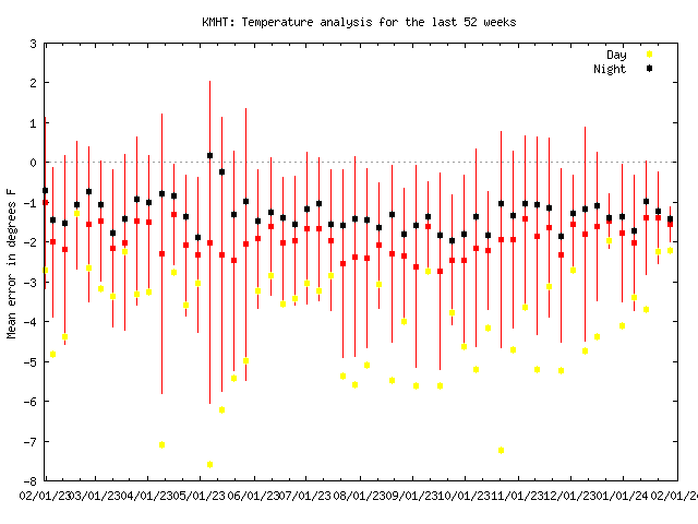
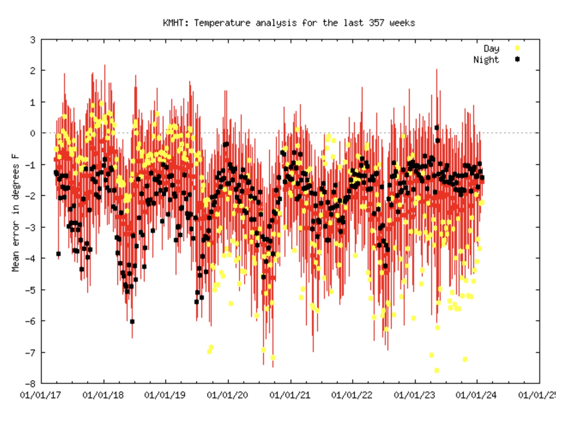
12 minutes ago, dendrite said:
Yeah long term they have a weird chart. There’s a jump in there around mid 2019? There’s some seasonal variation as well. It’s really messy and difficult to make much out of it although min error has recently striaghtlined and day temps have gotten worse.

Yeah its weird. Sometimes it'll be running closer to surrounding stations, but those near 32F events it really shows up.
-
I've noticed MHT is running warm since last year, but it seems to mostly show up when it's saturated. This past event the airport got 6" and never went below 34F. Consistent with a +1.5/+2.0 bias on Gladstone.
-
1
-
-
27 minutes ago, HiDefinitionNucleicAcid said:
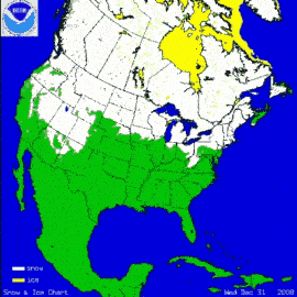
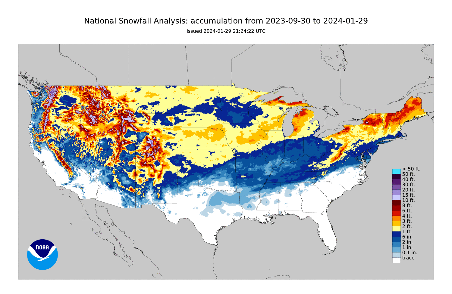
Non Sequitur /Just for fun, comparing accumulated snowfall from 9/30 to 1/29, accumulated snowfall from 9/30 to 4/30, and December 31st snow cover extent, for the seasons of '08 thru '23 (apologies for the resolution, was trying to fit the size limits
 ). Then below that this seasons accumulated snowfall from 9/30/23 to 1/29/24
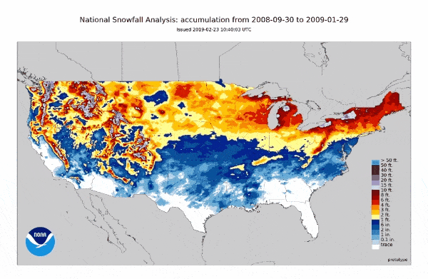
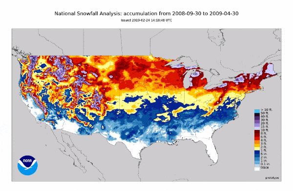

Eyeballing it; '11-'12 and '15-'16 were the worst for accumulation in New England region-wide. While on the flip side in recent years ('18-'19 onwards) NNE and the mountains seem to have had some decent seasons while the coastal plain has been way BN.
There's definitely some seasons in there that had hefty amounts of snow after Jan, but in the AN seasons there was already considerably more snow on the ground at the end of January than we have currently.
Also found it interesting to look at the snow cover at the end of December, it varies widely, and the '23 extent was shockingly low. While it seemed possible to eek out a marginally decent season on the coastal plain in '21-'22 with a low snow cover December, for the most part, lower December snow cover seems to coincide with BN seasons on the coastal plain in general.
I was just looking through some of this data too, I didn't realize how crappy it's been around MSP this year. Only 7.3" ytd, and +12,+4 for Dec/Jan.
-
1
-
-
31 minutes ago, 40/70 Benchmark said:
Last time I bet against the positive snow depth change maps in a light, marginal event. I was wrong.
They did well on the margins, but way too light in the banding/elevations. Some of those were giving AFN 2-3". Some kind of combo is probably the best. Maybe using them as the lower end of a forecast range.
.png.8be7a3d5a048eda4a5f1ae1300c74191.png)
Following a Miller A/B hybrid type coastal potential, Feb 13th ... As yet untapped potential and a higher ceiling with this one
in New England
Posted
-SN with a dusting up here on the fringe. Radar and trends look good pike south