heavy_wx
-
Posts
1,628 -
Joined
-
Last visited
Content Type
Profiles
Blogs
Forums
American Weather
Media Demo
Store
Gallery
Everything posted by heavy_wx
-
Pretty much all sleet here in North Laurel.
-
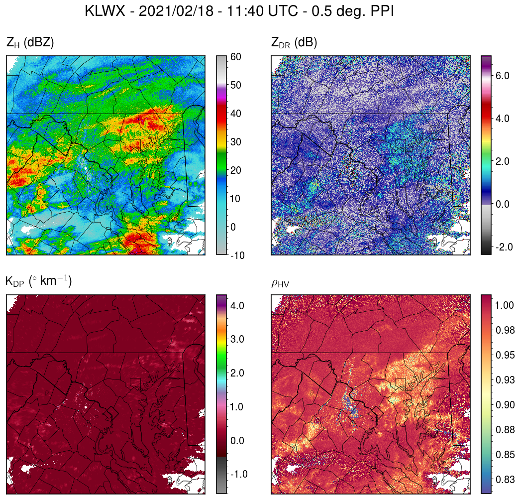
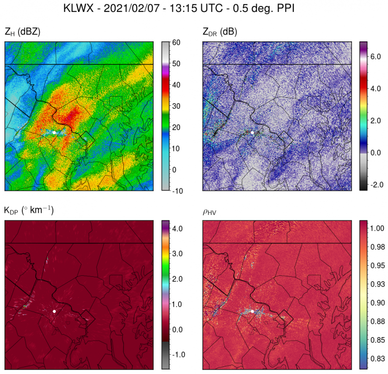
This event is a good example of why these "precip-type" radar maps are often flawed. The indicated precip type is not based purely on radar data; they add supplemental model data to determine the likeliest precip type at the location of each radar observation. The dual-polarization observations, however, show the sleet/snow line from southern Carroll County northeastward into PA, where reflectivity (ZH) and differential reflectivity (ZDR) values are enhanced due to bright banding, and correlation coefficient is reduced due to a mix of melting particles with different shapes. SImilarly, the rain/freezing rain transition is where the correlation coefficient increases south of Anne Arundel County, with both ZDR and ZH values decreasing here as raindrops dominate the backscatter. One other thing to note is the higher correlation coefficient and lower ZH and ZDR closer to the radar site in northern VA. The lack of a melting signature here is because the radar beam is closer to the ground at these locations and thus propagates beneath the melting layer; once the radar beam is higher off the ground at locations farther from the radar site, the polarimetric melting layer signature is visible. When the beam gets high enough, it samples above the melting layer and the signature disappears, as correlation coefficient becomes close to 1 and ZH and ZDR values decrease.

-
I measured 2.5" here with light snow currently. The amount of sleet mixing in last night definitely contributed to the south-north snowfall gradient in Howard County.
-
Mostly sleet here in southern Howard County with a coating of frozen precip on the ground.
-
Light snow here.
-
I got about 0.5" here in North Laurel.
-
Light rain with some wet aggregates mixed in here.
-
The coating of snow that was on the pavement here has melted.
-
Snow sizes have become much smaller here just east of the highest reflectivity (~40 dBZ) over Montgomery County.
-
Moderate snow with some very large aggregates falling right now.
-
All snow now with large, wet aggregates.
-
Mix of rain and wet snow here.
-
If surface temperatures were a couple degrees below freezing, I would feel more confident that ratios would be > 10:1. But while the antecedent air mass is fairly cold, there isn't a much of a surface high or mid-level confluence to our northeast promoting a low-level flow of cold air. Surface melting during the precipitation will definitely reduce ratios.
-
Yes, this is a much better sounding compared to what we saw last Sunday, where cloud tops were only around -10C. There's also some convective instabilitiy at cloud top near -20C that would be favorable for ice crystal generating cells; when these ice crystals fall into the saturated dendritic growth layer below, they grow rapidly and stick together, forming fluffy aggregates. If these profiles simulated by the 3-km NAM were to verify, I think the snow-liquid-ratio would be > 10:1 with fairly intense precipitation rates. FWIW, the profiles on the 06z-GFS have similar features around this time.
-

Jan 31st - 33rd Storm Obs and Disco like it's 1979
heavy_wx replied to Bob Chill's topic in Mid Atlantic
Moderate snow with low-density fluff in this band. Reminds me of lake effect. -
Jan 31st - 33rd Storm Obs and Disco like it's 1979
heavy_wx replied to Bob Chill's topic in Mid Atlantic
Getting some moderate-sized aggregates now in North Laurel. -
Jan 31st - 33rd Storm Obs and Disco like it's 1979
heavy_wx replied to Bob Chill's topic in Mid Atlantic
Actual light snow here in southern Howard County. -
Jan 31st - 33rd Storm Obs and Disco like it's 1979
heavy_wx replied to Bob Chill's topic in Mid Atlantic
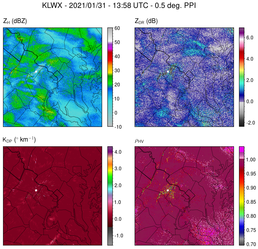
Finally getting some bigger aggregates and moderate snow within the higher reflectivity area from PG County into Howard County. Correlation coefficient and ZDR suggest that southern AA and PG county are starting to mix.
-
Jan 31st - 33rd Storm Obs and Disco like it's 1979
heavy_wx replied to Bob Chill's topic in Mid Atlantic
Snow growth here in southern Howard County is still quite poor, with small single crystals. -
Jan 31st - 33rd Storm Obs and Disco like it's 1979
heavy_wx replied to Bob Chill's topic in Mid Atlantic
Mostly needles in the lighter snow outside of the heavier bands here. Not too surprising given cloud-top temperatures in central MD are only around -10C. -
Jan 31st - 33rd Storm Obs and Disco like it's 1979
heavy_wx replied to Bob Chill's topic in Mid Atlantic
Getting larger, more aggregated snow now corresponding to higher reflectivity (>20 dBZ) and ZDR closer to 0 dB.
-
Jan 31st - 33rd Storm Obs and Disco like it's 1979
heavy_wx replied to Bob Chill's topic in Mid Atlantic
Light snow with tiny flakes here. -
Jan 31st - 33rd Storm Obs and Disco like it's 1979
heavy_wx replied to Bob Chill's topic in Mid Atlantic
Light snow here in southern Howard County with minimal accumulation so far. -
There's a pretty consistent emergence of a warm layer on most guidance between ~800-900 mb (except the GEM/RGEM) ; 850-mb temperatures generally get above freezing up to the MD-PA border between 06-12z on the Euro. The duration of snowfall from the coastal low will depend on the degree of mesoscale forcing and the low track, and these features are highly correlated since the best mesoscale forcing is north of the 700-mb low.
-
The 700-mb temperature gradient is definitely tighter on the 12z GFS compared to 06z, leading to greater frontogenetic forcing over the I-95 region. The model is also a bit colder, but its forecast boundary layer is still warm enough for rain for a time near and SE of I-95. If the stronger dynamics verify, I think the boundary layer could be less of an issue, especially given the favorable surface high position in SE Canada. Of course we could have those issues if the models end up developing the surface cyclone farther northwest.